Hobart, Wisconsin
| Hobart, Wisconsin | |
|---|---|
| Village | |
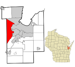 Location in Brown County and the state of Wisconsin. | |
| Coordinates: 44°30′49″N 88°8′35″W / 44.51361°N 88.14306°WCoordinates: 44°30′49″N 88°8′35″W / 44.51361°N 88.14306°W | |
| Country | United States |
| State | Wisconsin |
| County | Brown |
| Area[1] | |
| • Total | 33.06 sq mi (85.63 km2) |
| • Land | 32.95 sq mi (85.34 km2) |
| • Water | 0.11 sq mi (0.28 km2) |
| Elevation[2] | 682 ft (208 m) |
| Population (2010)[3] | |
| • Total | 6,182 |
| • Estimate (2012[4]) | 6,796 |
| • Density | 187.6/sq mi (72.4/km2) |
| Time zone | Central (CST) (UTC-6) |
| • Summer (DST) | CDT (UTC-5) |
| Area code(s) | 920 |
| FIPS code | 55-35150[5] |
| GNIS feature ID | 1583399[2] |
| Website |
hobart-wi |
Hobart is a village in Brown County in the U.S. state of Wisconsin. The population was 6,182 at the 2010 census. Hobart is a part of the Green Bay Metropolitan Statistical Area. A small portion of the village is part of the unincorporated census-designated place (CDP) given the name of Oneida, Wisconsin. Most of the CDP is located within the Town of Oneida in Outagamie County, Wisconsin. This CDP is an entity created solely for statistic purposes.
History
The village was formerly known as the Town of Hobart, until the entire town incorporated as the Village of Hobart on May 13, 2002.[6] Hobart is named for Episcopal Bishop John Henry Hobart of New York who sent missionaries to the Oneida people and ministered to them after removal from New York to Wisconsin.[7]
Geography
According to the United States Census Bureau, the village has a total area of 33.06 square miles (85.63 km2), of which, 32.95 square miles (85.34 km2) of it is land and 0.11 square miles (0.28 km2) is water.[1]
Demographics
| Historical population | |||
|---|---|---|---|
| Census | Pop. | %± | |
| 2000 | 5,090 | — | |
| 2010 | 6,182 | 21.5% | |
| Est. 2015 | 8,283 | [8] | 34.0% |

2010 census
As of the census[3] of 2010, there were 6,182 people, 2,180 households, and 1,828 families residing in the village. The population density was 187.6 inhabitants per square mile (72.4/km2). There were 2,275 housing units at an average density of 69.0 per square mile (26.6/km2). The racial makeup of the village was 78.1% White, 0.5% African American, 17.5% Native American, 1.2% Asian, 0.1% Pacific Islander, 0.1% from other races, and 2.5% from two or more races. Hispanic or Latino of any race were 2.3% of the population.
There were 2,180 households of which 37.0% had children under the age of 18 living with them, 72.2% were married couples living together, 7.6% had a female householder with no husband present, 4.1% had a male householder with no wife present, and 16.1% were non-families. 12.8% of all households were made up of individuals and 5.5% had someone living alone who was 65 years of age or older. The average household size was 2.84 and the average family size was 3.08.
The median age in the village was 43.4 years. 27.1% of residents were under the age of 18; 6.4% were between the ages of 18 and 24; 19% were from 25 to 44; 34.9% were from 45 to 64; and 12.8% were 65 years of age or older. The gender makeup of the village was 49.2% male and 50.8% female.
2000 census
As of the census[5] of 2000, there were 5,090 people, 1,717 households, and 1,468 families residing in the village. The population density was 153.5 people per square mile (59.3/km²). There were 1,758 housing units at an average density of 53.0 per square mile (20.5/km²). The racial makeup of the village was 80.57% White, 0.10% African American, 16.66% Native American, 0.69% Asian, 0.08% Pacific Islander, 0.39% from other races, and 1.51% from two or more races. Hispanic or Latino of any race were 0.86% of the population.
There were 1,717 households out of which 40.8% had children under the age of 18 living with them, 75.4% were married couples living together, 6.5% had a female householder with no husband present, and 14.5% were non-families. 10.7% of all households were made up of individuals and 4.6% had someone living alone who was 65 years of age or older. The average household size was 2.96 and the average family size was 3.20.
In the village the population was spread out with 29.8% under the age of 18, 5.8% from 18 to 24, 25.7% from 25 to 44, 31.2% from 45 to 64, and 7.5% who were 65 years of age or older. The median age was 39 years. For every 100 females there were 96.8 males. For every 100 females age 18 and over, there were 96.4 males.
The median income for a household in the village was $69,034, and the median income for a family was $76,626. Males had a median income of $49,813 versus $30,458 for females. The per capita income for the village was $29,059. About 4.1% of families and 6.5% of the population were below the poverty line, including 9.6% of those under age 18 and 10.6% of those age 65 or over.
References
- 1 2 "US Gazetteer files 2010". United States Census Bureau. Retrieved 2012-11-18.
- 1 2 "US Board on Geographic Names". United States Geological Survey. 2007-10-25. Retrieved 2008-01-31.
- 1 2 "American FactFinder". United States Census Bureau. Retrieved 2012-11-18.
- ↑ "Population Estimates". United States Census Bureau. Retrieved 2013-06-24.
- 1 2 "American FactFinder". United States Census Bureau. Retrieved 2008-01-31.
- ↑ http://www.legis.state.wi.us/lrb/bb/05bb/744-779.pdf
- ↑ http://www.witowns.com/OurWisconsinTowns.htm
- ↑ "Annual Estimates of the Resident Population for Incorporated Places: April 1, 2010 to July 1, 2015". Retrieved July 2, 2016.
- ↑ "Census of Population and Housing". Census.gov. Retrieved June 4, 2015.
External links
| Core city |  | |
|---|---|---|
| Largest municipalities over 10,000 in 2010 | ||
| Municipalities under 10,000 in 2010 | ||
| Counties | ||
Municipalities and communities of Brown County, Wisconsin, United States | ||
|---|---|---|
| Cities | 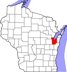 | |
| Villages | ||
| Towns | ||
| CDPs | ||
| Unincorporated communities |
| |
| Indian reservation | ||
| Ghost towns/ neighborhoods | ||
| Footnotes | ‡This populated place also has portions in an adjacent county or counties | |