Wisconsin Highway 54
| ||||
|---|---|---|---|---|
| Route information | ||||
| Maintained by WisDOT | ||||
| Length: | 243.1 mi[1] (391.3 km) | |||
| Major junctions | ||||
| West end: |
| |||
|
| ||||
| East end: |
| |||
| Location | ||||
| Counties: | Buffalo, Trempealeau, Jackson, Wood, Portage, Waupaca, Outagamie, Brown, Kewaunee | |||
| Highway system | ||||
| ||||

State Trunk Highway 54 (often called Highway 54, STH 54 or WIS 54) is a Wisconsin state highway running east–west across central Wisconsin. It is 243.12 miles (391.26 km) in length.
Termini
The western terminus of Highway 54 is at the Minnesota state line at Winona, Minnesota on the North Channel Bridge. The eastern terminus is at Highway 42 in downtown Algoma at the corner of Jefferson and Lake Streets.
Municipalities served by Highway 54
- Black River Falls
- Wisconsin Rapids
- Plover
- Waupaca
- New London
- Shiocton
- Black Creek
- Seymour
- Green Bay
- Algoma
Images
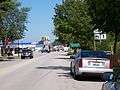 East terminus in Algoma
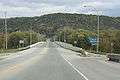 West terminus
| Wikimedia Commons has media related to Wisconsin Highway 54. |
References
This article is issued from Wikipedia - version of the 6/15/2015. The text is available under the Creative Commons Attribution/Share Alike but additional terms may apply for the media files.