Henrysville, Wisconsin
| Henrysville, Wisconsin | |
|---|---|
| Unincorporated community | |
 Henrysville  Henrysville | |
| Coordinates: 44°26′38″N 87°47′09″W / 44.44389°N 87.78583°WCoordinates: 44°26′38″N 87°47′09″W / 44.44389°N 87.78583°W | |
| Country | United States |
| State | Wisconsin |
| County | Brown |
| Town | Eaton |
| Elevation | 896 ft (273 m) |
| Time zone | Central (CST) (UTC-6) |
| • Summer (DST) | CDT (UTC-5) |
| Area code(s) | 920 |
| GNIS feature ID | 1577638[1] |
Henrysville is an unincorporated community in the Town of Eaton, Brown County, Wisconsin, United States. It is located at the junction of Wisconsin Highway 29 and County Highway P 12 miles (19 km) east-southeast of Green Bay.[2]
References
- ↑ U.S. Geological Survey Geographic Names Information System: Henrysville, Wisconsin
- ↑ Brown County (PDF) (Map). Wisconsin Department of Transportation. 2011. Retrieved 2011-09-11.
Municipalities and communities of Brown County, Wisconsin, United States | ||
|---|---|---|
| Cities | 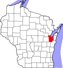 | |
| Villages | ||
| Towns | ||
| CDPs | ||
| Unincorporated communities |
| |
| Indian reservation | ||
| Ghost towns/ neighborhoods | ||
| Footnotes | ‡This populated place also has portions in an adjacent county or counties | |
This article is issued from Wikipedia - version of the 7/28/2016. The text is available under the Creative Commons Attribution/Share Alike but additional terms may apply for the media files.