Ho Chi Minh City Metro
| Overview | |
|---|---|
| Owner | Management Authority for Urban Railways |
| Locale | Ho Chi Minh City, Vietnam |
| Transit type | Rapid transit |
| Number of lines |
2 (under construction) 3 (planned) |
| Operation | |
| Operation will start | 2020[1] |
| Headway | 4 minutes[2] |
| Technical | |
| System length | 107 km (66.5 mi) (planned) |
| Track gauge | 1,435 mm (4 ft 8 1⁄2 in) standard gauge[2] |
| Top speed | 80 km/h (50 mph)[2] |
The Ho Chi Minh City Metro (Vietnamese: Dự án đường sắt đô thị Thành phố Hồ Chí Minh) is a proposed rapid transit network that will serve Ho Chi Minh City in Vietnam. The network was first proposed in 2001[2] as part of a comprehensive public transport network plan including Ho Chi Minh City and neighbouring provinces, with the aim of avoiding the severe traffic congestion problems that have affected other Asian cities (such as Hanoi).[3] Most of the network is currently in the planning stages, with projects for different lines advancing as funds become available. The network's first line, connecting Bến Thành Market and Suối Tiên Park in District 9, was originally scheduled for completion in 2017–18,[4][5] but later put back to 2020.[1] Construction of a second line began in August 2010.[6]
Plan
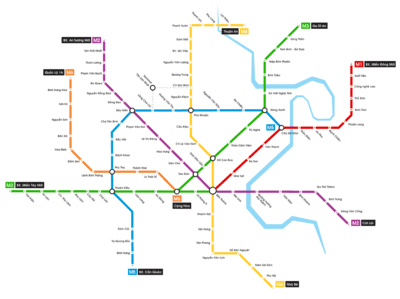
The Ho Chi Minh City Metro project is managed by the city's Management Authority for Urban Railways (MAUR), a government unit working directly under the Chairman of the People's Committee of Ho Chi Minh City.[7] The most recent plan put forth by this unit calls for no less than six urban rail lines. The city’s transport development master plan to 2020 envisages developing three monorail or light rail lines with a total length of 37 kilometres (23 mi) and six underground metro routes with a total length of 107 kilometres (66 mi).[8] Bến Thành Market in District 1, already a major hub for bus traffic, will become a major hub connecting several lines.
| Line description | Length (km) | Stations | Route |
|---|---|---|---|
| Line 1 | 19.7 | 14 | Bến Thành Market–Suối Tiên Park, District 9 |
| Line 2 | 11.3[10] | 11 | Bến Thành Market–Tham Luong, District 12 |
| Line 3 | 10.4 | ? | Bến Thành Market–Bình Tân |
| Line 4 | 16 | ? | Lang Cha Ca, Tân Bình–Van Thanh Park, Bình Tân |
| Line 5 | 17 | ? | Thủ Thiêm, District 2–Can Giuoc, District 8 |
| Line 6 | 6 | ? | Ba Queo, Tân Bình–Phu Lam, District 6 |
Line 1
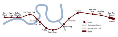
On April 10, 2007, the city government approved the US$1.1 billion Line 1. It will run for 19.7 km from Bến Thành Market, underground for 2.6 km past the Opera House, Ba Son Shipyard, and then cross the Saigon River on an elevated track, passing through District 2 on the way to Suối Tiên Park and the terminus in Long Bình in District 9. In all, Line 1 will include 14 stations, with three of these (Ben Thanh, the Opera House and Ba Son) being underground.[9]
Work to build a US$28 million depot in Long Binh for Line 1 began on February 21, 2008.[11][12] Construction of the elevated section, east of the Saigon River, started in August 2012.[13] The contract for the 3-station underground segment was to follow shortly after. The Japan Bank for International Cooperation will provide US$904.7 million to meet 83% of the cost, and the city government US$186.6 million.[8]
Completion of Line 1 was originally planned for early 2018,[13] but is now planned for 2020.[1] Planners expect the route to serve more than 160,000 passengers daily upon launch, increasing to 635,000 by 2030 and 800,000 by 2040. All stations along the route are expected to accommodate the disabled, with automatic ticket vending machines, telephone booths, restrooms, subway doors and information bulletins accessible to the handicapped and visually impaired.[12]
Unfortunately, as the basic systems engineering such as Requirements Management, Systems Assurance and the pre-requisite transverse engineering studies of noise and vibration, stray current mitigation, earthing and bonding have not been undertaken by the Japanese consultants or Japanese contractors, the Technical Designs of the Japanese contractors cannot be completed or approved.
Line 2

Plans for the US$1.2 billion Line 2 were submitted in November 2008 by MVA Asia Limited[14] and approved by the government in December 2008. This line will include 11 stations stretching between Bến Thành Market and Tham Luong in District 12, following a route through Pham Hong Thai, Cach Mang Thang Tam and Trường Chinh streets. Out of the main section's total length of 11.3 km, 9.6 km will be underground.[10] Major stations will include Trường Chinh (Tay Ninh Bus Station), near Tan Son Nhat Airport, and Hòa Hưng, near Saigon Railway Station. An extension of Line 2 east of Bến Thành Market to Thủ Thiêm New was originally proposed by MVA; this extension would bring the line's total length to 19 km.[4][15]
The project's projected cost will be financed by the German Bank for Reconstruction, the Asian Development Bank and the European Investment Bank.[4][16] In February 2008, the German government announced EUR 86 million of funding towards the project.[11] Construction officially began in August 2010,[6] starting with 25 hectare-wide Tham Luong Depot, for opening in 2020.[17]
Line 3
The third metro line would span the distance between Bến Thành Market to the east and An Lac in Bình Tân District to the west,[9] passing through Districts 5 and 6—the area known as Cholon, or "Chinatown". Fewer details have emerged about the third line than the others, although the city's People's Committee is reported to have approached the French government for funding and support.[18] A 2006 document suggested a possible extension of Line 3 north of Bến Thành Market to Thủ Đức District, although officials have yet to confirm whether this extension will be built.[15]
Line 4
Spanish consulting company Ardanuy Ingenieria won a contract in October 2009 to provide a feasibility study of Line 4 of the six-line project.[9] This line would stretch 16 km from Lang Cha Ca crossroad in Tân Bình District (near Tan Son Nhat Airport) to Van Thanh Park in Bình Thạnh District.
Lines 5-6
On April 4, 2009, Spain's IDOM, Ingeniería, Arquitectura y Consultoría S.A. signed a contract with HCMC Urban Railway to provide a feasibility study for lines 5 (from Thủ Thiêm, District 2 to Can Giuoc, District 8 – 20 km) and 6 (Ba Queo, Tân Bình to Phu Lam, District 6 – 6 km). The study was to be completed within 12 months.[19]
In September 2010 Spanish company GEV signed an agreement with HCM City's Management Board of Urban Railway to build the first phase of the Metro 5 route between Sai Gon Bridge and Bay Hien Intersection in Tân Bình District. Work on the route is expected to begin by the end of April 2011.[20]
In September 2013 agreement was reached with the Asian Development Bank, the European Investment Bank, and the Spanish Government to provide Euro850m to finance the construction of line 5 - with any additional provided by the Vietnamese Government. A revised construction start of 2015 was provided.[21]
Other lines
China Shanghai Corporation for Foreign Economic & Technological Cooperation (Sfeco) has carried out a pre-feasibility study for a 12 km Nguyen Oanh-Nguyen Van Linh Metro route, between Gò Vấp District and District 4.[22] A 2006 document indicated that a subsidiary line connecting the line to Tan Son Nhat Airport and a southward extension to Nhà Bè District may have been considered.[15]
Initial 2001 plan
According to the original master plan submitted in February 2001, the inner metro system would comprise the following routes, many of which have been adapted or superseded by the more recent 2007 plan. The plan was originally expected to cost US$1.5 billion over 10 years, as part of a US$3.35 billion program to build a rail network serving Ho Chi Minh City and surrounding provinces.[23]
| Line description | Length (km) | Stations |
|---|---|---|
| Northwest–Southwest (including Bến Thành Market–Tan Son Nhat Airport) | 46.86 | 44 |
| Inner Belt (including Bến Thành Market–Bình Tây Market, Cholon) | 43.14 | 45 |
| Hòa Hưng, District 10–Hanoi Highway–Thủ Thiêm, District 2 | 21 | 18 |
| Bến Thành Market - District 2–District 9 - Thủ Đức District | 27.5 | 18 |
| Hòa Hưng, District 10–Hiệp Bình Chánh, Thủ Đức District–Biên Hòa | 46 | 42 |
Priority lines
Three lines were considered a priority of the 2001 plan, two of them fully or partly underground and one fully elevated:[3]
- A 7.5-kilometre (4.7 mi) north-south line, partly underground and partly elevated, connecting Tan Son Nhat Airport and Bến Thành Market, via Hòa Hưng in District 10;
- A 7-kilometre (4.3 mi) east-west line, fully underground, connecting Bến Thành Market with Bình Tây Market in Cholon, similar to Line 3 of the 2007 plan;
- An 11-kilometre (6.8 mi) southwest-northeast line, fully elevated, connecting Hòa Hưng in District 10 to Binh Trieu in Thủ Đức District, following existing railway lines.
Proposed extensions to these lines included: extending the Tan Son Nhat line north to Quang Trung Software Park, eventually expanding further to the northwest and southwest to create a much longer 47 km line; extending the Bình Tây/Cholon line to form a circular "Inner Belt" Line, which would loop around the airport; and building a doubletrack elevated express line to extend the Hòa Hưng-Binh Trieu line out to Biên Hòa.[3]
Other lines
Other lines to be built according to the 2001 plan included a 27.5-kilometre (17.1 mi) line connecting Bến Thành Market to Thủ Đức District, via Districts 2 and 9, similar to (but distinct from) Line 1 of the 2007 plan, and a 16-kilometre (9.9 mi) line from Hòa Hưng in District 10 to Bình Chánh District.[3]
Several more inter-city rail lines were planned, including a Long Binh-Hóc Môn route, a Hóc Môn–Bình Chánh–Tiền Giang route, a Thủ Đức–Long Bình–Long Thành–Vũng Tàu route and a Thủ Thiêm–Long Bình–Vũng Tàu route.[2]
Technical specifications
The 2001 plan proposed the following technical parameters:[2]
- Platform length: 125 metres (410 ft)
- Average distance between stations 700–1,300 metres (2,300–4,300 ft)
- Maximum speed: 80 kilometres per hour (50 mph)
- Headway: 4 min. (min. 2 min.)
- Gauge: 1,435 mm (4 ft 8 1⁄2 in) standard gauge
- Vehicle width: 3 metres (9.8 ft)
Fares and ticketing
To encourage high ridership, fares on the Ho Chi Minh City Metro network will be set low, on the order of VND 2,500 (about US$0.16). By comparison, bus fares within the city are generally VND 3,000 (as of 2013, bus fares are at around VND 5,000 to VND 7,000 [24][25]). A common farecard, valid on both the metro network and bus network, will be made available as well.[26]
See also
Notes and references
- References
- 1 2 3 "Ho Chi Minh City selects underground contractors". Railway Gazette International. 26 July 2014. Retrieved 2015-04-25.
- 1 2 3 4 5 6 7 Robert Schwandl (2007). "Ho Chi Minh City Metro". UrbanRail.net. Retrieved 2010-05-26.
- 1 2 3 4 5 "Ho Chi Minh City plans to build a metro network". International Railway Journal. 1 May 2002. Retrieved 2010-05-27.
- 1 2 3 "The work begins: HCM City to have first subway in 2014". VietnamNet Bridge. 30 April 2010.
- ↑ "Work starts on Ho Chi Minh City metro line". International Railway Journal. 24 August 2010. Retrieved 2010-08-24.
- 1 2 "Ceremony launches work on Ho Chin Minh City metro Line 2". Railway Gazette International. 25 August 2010.
- ↑ "Overview of Management Authority for Urban Railways". Retrieved 2010-04-04.
- 1 2 M.Vong (10 April 2007). "Vietnam to build first subway with Japanese aid". Thanh Nien. Retrieved 2010-05-14.
- 1 2 3 4 "Ho Chi Minh City Metro". Railway-Technology.com. Retrieved 2010-04-04.
- 1 2 "City sets to start construction of metro route No.2". Thanh Nien. Sai Gon Giai Phong. 2 June 2010. Retrieved 2010-06-10.
- 1 2 "Ho Chi Minh City breaks ground". Railway Gazette International. 28 February 2008. Retrieved 2010-05-14.
- 1 2 Duc Trung (18 February 2008). "Vietnam's first subway line ready to break ground". Thanh Nien.
- 1 2 "Work starts on Ho Chin Minh City metro Line 1". Railway Gazette International. 31 August 2012.
- ↑ Dinh Muoi (30 November 2008). "Plans for HCMC's second metro route submitted". Thanh Nien. Retrieved 2010-05-14.
- 1 2 3 MVA Asia Ltd (October 2006). "Preparing the Ho Chi Minh City Metro Rail System Project: Technical Assistance Reports" (PDF). Asian Development Bank. p. 4. Retrieved 2010-06-10.
- ↑ Dinh Muoi (11 December 2008). "HCMC's subway route No.2 approved". Thanh Nien. Retrieved 2010-05-14.
- ↑ theaveasia (2015-01-20). "Construction work starts on Metro Line No. 2 in Ho Chi Minh City". AveAsia. Retrieved 2016-06-17.
- ↑ Tran Tam (12 June 2009). "City seeks French support for metro project". Thanh Nien. Retrieved 2010-05-14.
- ↑ Minh Quang (7 April 2009). "Spanish firm signs metro deal". Thanh Nien. Retrieved 2010-05-14.
- ↑ "Subterranean urban projects receive funds". VietNam Net. 13 September 2010. Retrieved 2010-09-13.
- ↑ "City Metro Project receives Euro850 million funding". SGGP. 12 September 2013. Retrieved 2013-09-12.
- ↑ "China investor likely to replace Russian firms in subway project". The SGT Daily. October 2006. Retrieved 2010-05-14.
- ↑ "Ho Chi Minh City Metro Plan". International Railway Journal. January 2001. Retrieved 2010-05-26.
- ↑ "Bus fares to be increased since October 1 in Hanoi". VNExpress. 22 August 2012. Retrieved 2013-06-01.
- ↑ "Bus fares to be increased in Ho Chi Minh city". VNExpress. 25 December 2012. Retrieved 2013-06-01.
- ↑ David M. Lenard (3 November 2004). "Ho Chi Minh's subway dreams". Asia Times. Retrieved 2010-06-11.
- Bibliography
- MVA Asia Ltd (October 2006). "Preparing the Ho Chi Minh City Metro Rail System Project: Technical Assistance Reports" (PDF). Asian Development Bank. Retrieved 2010-06-10.
- MVA Asia Ltd (October 2006). "Preparing the Ho Chi Minh City Metro Rail System Project: Consultant's Reports" (PDF). Asian Development Bank. Retrieved 2010-06-10.
External links
| Wikimedia Commons has media related to Ho Chi Minh City Metro. |
| Government | |||||||||||
|---|---|---|---|---|---|---|---|---|---|---|---|
| Road |
| ||||||||||
| Rail |
| ||||||||||
| Water |
| ||||||||||
| Aviation |
| ||||||||||
| Other topics |
| ||||||||||
| |||||||||||
| Indonesia |
|
|---|---|
| Malaysia | |
| Myanmar | |
| Philippines | |
| Singapore | |
| Thailand |
|
| Vietnam | |
Note: Under construction & planned lines are in Italics | |