Bình Thạnh District
| Bình Thạnh District Quận Bình Thạnh | |
|---|---|
| Urban District | |
 Position in HCMC's core | |
 Bình Thạnh District Location in Vietnam | |
| Coordinates: 10°48′12″N 106°41′23″E / 10.80333°N 106.68972°ECoordinates: 10°48′12″N 106°41′23″E / 10.80333°N 106.68972°E | |
| Country |
|
| Centrally Governed City | Ho Chi Minh City |
| Seat | 6 Phan Đăng Lưu |
| Wards | 20 wards |
| Government | |
| • People's Committee | Nguyễn Thị Thu Hà |
| Area | |
| • Total | 20.8 km2 (8.0 sq mi) |
| Population (2010) | |
| • Total | 470,054 |
| • Density | 23,000/km2 (59,000/sq mi) |
| Demographics | |
| Time zone | ICT (UTC+07) |
| Website | binhthanh.hochiminhcity.gov.vn |
Bình Thạnh is a district of Ho Chi Minh City in Vietnam. As of 2010, the district had a population of 470,054, a total area of 21 km².[1]
The name "Bình Thạnh" was formed from the name of two wards in the old Gò Vấp District, Binh Hoa and Thanh My Tay. In 1976, those two wards were removed from Gò Vấp District to create Bình Thạnh District.
Administrative division
Bình Thạnh is divided into 20 wards. They are wards 1, 2, 3, 5, 6, 7, 11, 12, 13, 14, 15, 17, 19, 21, 22, 24, 25, 26, 27 and 28. Wards 4, 8, 9, 10, 16, 18, 20 and 23 were omitted by merging them to other wards.
Geographical location
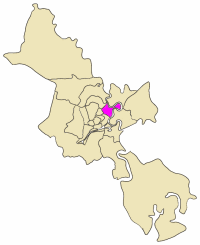
Bình Thạnh borders district 1 to the south, district 1, Phú Nhuận and Gò Vấp districts to west, Saigon River, District 2 and Thủ Đức District to the east.
The Bình Quới Tourist Village is located on the Thanh Da peninsula on the Saigon River, in the Bình Thạnh District.
References
- ↑ "HCMC's Population and population density in 2010 by district". HCMC Office of Statistics. Retrieved Feb 4, 2014.

