Route 443 (Israel)
| |
|---|---|
|
מעלה בית חורון Ma'ale Beit Horon | |
| Ascent of Bethoron | |
 | |
| Route information | |
| Length: | 32 km (20 mi) |
| Major junctions | |
| West end: | Lod (Ginaton Junction) |
| East end: | Highway 45/Begin Expressway to Jerusalem |
| Location | |
| Major cities: | Modi'in-Maccabim-Re'ut, Modi'in Illit, Giv'at Ze'ev |
| Highway system | |
| Highways | |


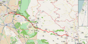
Route 443 (Hebrew: כביש 443, מעלה בית חורון) is also known as Ma'ale Beit Horon (Bethoron Ascent), following the ancient east-west trade route connecting the Via Maris and the Way of the Patriarchs. It is the main highway connecting Tel Aviv and Gush Dan with Jerusalem via Modi'in. While technically listed as a regional road, it is for the most part a divided, four-lane highway which utilises some grade separation and interchanges, as well as major at-grade intersections, and thus is not classified as a motorway, even though there is a short motorway section on its western end, connecting it to westbound Highway 1.
Route
Route 443 begins as a local street near downtown Lod. Leaving Lod to the east, it becomes a divided highway, crossing Highway 1 and Highway 6 at the Ben Shemen Interchange, and continuing to Shilat junction, which serves as the entrance for the Modi'in area. It then continues through the West Bank in the Matte Binyamin Regional Council, near Ramallah. Upon passing Givat Ze'ev Junction, its official designation becomes Highway 45 which continues directly to Jerusalem's Highway 50 (Begin Boulevard). A spur, Route 436, also links it with Jerusalem through Giv'at Ze'ev and the Ramot neighborhood.
The Road in Antiquity
The road was used during many battles in antiquity due to its unique geography. It is mentioned in several ancient writings.
- In Joshua (Joshua 10:10), it is the location of a battle during the conquest of the Land of Canaan.
- In 1 Samuel (1Samuel 13:18), the road is used during a battle between the Israelites and the Philistines.
- It is also mentioned in 1 Maccabees (1 Maccabees 3:13-26) describing the Battle of Beth Horon between the Macabees and the Seleucid Empire.
- Later, it is the location of a battle with the Romans as described by Josephus in Wars of the Jews (Ch. 19, paragraphs 2 & 8).
As opposed to the modern Highway 1 which twists and turns, rises and falls between mountains and valleys on its way to Jerusalem through the Judean hills, the central portion of Highway 443 runs along a ridge line and maintains a relatively stable grade.
see also: Bet-Horon
Use by Palestinian traffic

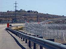
The route crosses into the West Bank just north of Maccabim, and continues thereafter until the junction just north of Givat Ze'ev; Palestinian traffic is permitted to use the road between these two points.
Several access roads connecting Palestinian villages with this section of Route 443 were closed in September 2000 due to the outbreak of the Second Intifada.[1] Frequent fire bomb attacks and fatal shootings on Israeli traffic saw the erection of anti-sniper barricades on parts of the highway adjacent to Palestinian-populated areas.[2][3][4][5]
In March 2008, following a challenge by the Association for Civil Rights in Israel, Israel's Supreme Court permitted for six more months the right of the IDF to limit Palestinian traffic in this section, deeming the restrictions necessary to prevent attacks.[6][7] On December 29, 2009 Israel's High Court of Justice upheld the ACRI's petition against an IDF order barring Palestinian traffic: the ruling became effective May 28, 2010, and unrestricted Palestinian traffic was again permitted.
Junctions and interchanges (west to east)
| km | Name | Type | Meaning | Location | Road(s) Crossed |
|---|---|---|---|---|---|
| ↓Lod↓ | |||||
| HaHashmonaim Blvd. | |||||
| 0 | כיכר הבנים (HaBanim Square) |
|
The Sons | Central Lod | Herzl St. Katzenelson St. Uri Nehushtan St. |
| 0.15 | |
Central Lod | Amos Vigodski St. | ||
| 0.2 | כיכר השוטר (HaShoter Square) |
|
The Policeman | Mishmar Nof neighborhood | Tzahal Blvd. Henrietta Szold St. |
| 0.4 | |
Mishmar Nof neighborhood | Derech Beit HaDin | ||
| 0.5 | |
Mishmar Nof neighborhood | Resh-Aleph St. HaPrachim St. | ||
| 0.8 | |
Neve Nof neighborhood | Kehilat New York St. | ||
| 1 | |
Neve Nof neighborhood | Erez St. | ||
| 1.1 | |
Ramat Eshkol neighborhood | General LeClerc St. | ||
| 1.3 | כיכר חיל התחזוקה (Heil HaTahzuka Square) |
|
Quartermaster Corps | Yasmin, Shabazi, Neve Nof neighborhoods |
HeHalutz St. Haim Moshe Shapira St. |
| ↑Lod Municipal Boundary↑ | |||||
| 1.6 | צומת גינתון (Ginaton Junction) |
|
Little Garden | Lod | |
| 2.5 | צומת בו שמן (Ben Shemen Junction) |
|
Fruitful | Moshav Ben Shemen, Moshav Ginaton |
local roads |
| 3.3 | |
Ben Shemen Youth Village and Agricultural School |
local road | ||
| 4.1 | מחלף בן שמן (Ben Shemen Interchange) |
|
Named after location | Ben Shemen | |
| 4.9 | צומת מודיעים (Modi'im Junction) |
|
Named after location of ancient village Modi'im Informers |
north to Rosh HaAyin |
|
| 5 | צומת מודיעים (Modi'im Junction) |
|
south to Kfar Daniel, Moshav Gimzo |
| |
| 6.2 | 443 Extension | |
from/to Tel Aviv | from/to | |
| 6.5 | צומת מצפה מודיעין (Mitzpe Modi'in Junction) |
|
Modi'in Overlook | JNF Ben Shemen Forest "Mitzpe Modi'in" |
local road |
| 7.5 | |
Mitkan Adam Army Base | local road | ||
| 8.1 | צומת נאות קדומים (Neot Kedumim Junction) (westbound only) |
|
Beauties of Ancient Times | JNF Ben Shemen Forest "Neot Kedumim" |
local road |
| 10.1 | צומת מבוא מודיעים (Mevo Modi'im Junction) |
|
Gateway to Modi'im | Mevo Modi'im JNF Ben Shemen Forest "Zaglembie Martyrs Memorial" |
local road |
| 10.8 | צומת הנקתפים (HaNiktafim Junction) (eastbound only) |
|
Harvested | JNF Ben Shemen Forest "Yad HaNiktafim" |
local road |
| 11.6 | צומת מכבים (Maccabim Junction) (westbound only} |
|
Named for The Maccabees | JNF Ben Shemen Forest "Tombs of the Maccabees" |
|
| 12.2 | |
Modi'in (west) Modi'in Industrial Zone |
Yehuda Hamaccabi St. | ||
| 14 | (westbound only) | |
Shilat Modi'in Illit Modi'in-Maccabim-Re'ut |
filling station | |
| 14.2 | צומת שילת (Shilat Junction) |
|
Named after location | Shilat Modi'in Illit Modi'in-Maccabim-Re'ut |
HaHashmonaim Blvd. |
| 15.7 | צומת מכבים-רעות (Maccabim-Re'ut Junction) |
|
Maccabees-Friendship | Maccabim-Re'ut | Yair Parag Road |
| 17.1 | Green Line | ||||
| 17.35 | צומת ספא (Saffa Junction) |
|
Named after location | Green Line | passenger transfer to Saffa |
| 17.4 | Maccabim Security Checkpoint | ||||
| | |||||
| 17.5 | צומת בית חורון (Beit Horon Junction) |
|
Named after location House of Horon |
Beit Sira | local road yellow (Israeli) license plates |
| 18 | |
Saffa, Beit Ur al-Tahta | | ||
| 18.8 | (eastbound only) | |
Beit Sira | | |
| 19.5 | (westbound only) | |
Beit Ur al-Tahta | | |
| 21.4 | (westbound only) | |
Beit Ur al-Tahta Kharbatha al-Misbah Beit Liqya |
| |
| 21.6 | (eastbound only) | |
Beit Ur al-Tahta Kharbatha al-Misbah Beit Liqya |
local road to Ramallah yellow (Israeli) license plates | |
| 22.2 | (eastbound only) | |
Kharbatha al-Misbah | filling station | |
| 24 | (westbound only) | |
Beit Ur al-Fauqa | local road from Ramallah yellow (Israeli) license plates | |
| 27 | מחלף בית חורון (Beit Horon Interchange) |
|
Named after location House of Horon |
Beit Horon al-Tira |
local road |
| | |||||
| 28.1 | (eastbound only) | |
Agan HaAyalot Givat Ze'ev (west) |
local road | |
| 31.1 | Ofer Security Checkpoint | ||||
| 31.8 | צומת גבעת זאב (Giv'at Ze'ev Junction) |
|
Wolf Hill | Giv'at Ze'ev Ofer Prison |
(443 continues as: to (Begin Boulevard) |
References
- ↑ The law as roadkill on Highway 443, Haaretz, September 26, 2006.
- ↑ Yaakov Katz (2007-04-17). "4 Israelis wounded in drive-by shooting". Jerusalem Post. Retrieved 2013-01-26.
- ↑ Israeli driver killed in ambush near Givat Ze'ev
- ↑ Couple shot dead in ambush, children lightly hurt
- ↑ Two murdered in terror attacks
- ↑ Barring Palestinians from Highway 443 prevents attacks on Israel, court hints, March 4, 2008, Jerusalem Post
- ↑ Ethan Bronner (2008-03-28). "A road becomes a dividing line in the West Bank" (Global Edition of the New York Times ed.). International Herald Tribune. Retrieved 2013-01-26.
| Roads |
| ||||||
|---|---|---|---|---|---|---|---|
| Bus operators | |||||||
| Rail transport |
| ||||||
| Sea ports | |||||||
| Aviation |
| ||||||
| Cable cars | |||||||
| By city | |||||||
| Smart cards | |||||||
Coordinates: 31°53′54″N 35°02′17″E / 31.89833°N 35.03806°E