Highway 60 (Israel)
| |
|---|---|
| כביש 60 / Kvish Shishim | |
| Way of the Patriarchs | |
| Route information | |
| Length: | 235 km (146 mi) |
| Major junctions | |
| South end: |
Beersheba Highway 25 (David Hacham Blvd.) |
| |
| North end: |
Nazareth HaMusachim Junction |
| Location | |
| Major cities: | Beersheba, Hebron, Gush Etzion, Jerusalem, Afula, Nazareth |
| Highway system | |
| Highways | |


Highway 60 or Route 60 (Hebrew: כביש 60, "Kvish Shishim") is a south-north intercity road in Israel and the West Bank that stretches from Beersheba to Nazareth.
Route
The route is also known as the "Way of the Patriarchs" (Hebrew: דרך האבות) since it follows the path of the ancient highway that runs along the length of the central watershed, and which figures prominently in the travels of the Biblical patriarchs.
From its junction with Highway 40 in Beersheba to the city's outskirts, Route 60 is a dual carriageway with at-grade intersections. While it continues on to serve as the main north-south artery between Israeli settlements and Palestinian communities such as the cities of Hebron and Bethlehem in the southern West Bank, it is a two-lane, shoulderless road until past Hebron at Gush Etzion Junction, where it regains its lane-separation until short of Bethlehem, that section having recently been widened. Upon entering Jerusalem, its lanes are again mostly separated as it serves as a central artery in the city center. In the northern quarters it becomes a separate grade freeway with multiple interchanges, from where it continues through the central and northern West Bank as a two-lane road, not being divided again until the stretch between Afula and its terminus in downtown Nazareth.[1]
At present, the highway is non-contiguous pending final status agreement between Israel and the Palestinians. The section through Jenin is closed to yellow (Israeli) license plates. The sections north and south of the West Bank and through Jerusalem are closed to green (Palestinian Authority) license plates.[2]
Due to it running through a mainly rural setting, many of the junctions along its route feature hitchhiking posts called trempiadas.
Highway 60 in Jerusalem
Within Jerusalem, Highway 60, known by the municipality as the Talpiot–Atarot Axis and often referred to by its official Jerusalem Municipality designation, "Road 1" (not to be confused with National Highway 1), is the central north-south artery running through the city centre. The Jerusalem portion of the road begins at the Tunnels Road (the northern end of the Bethlehem Bypass), passes the edges of Gilo and Beit Safafa, joins the "Hebron Road" (Hebrew: דרך חברון) from Bethlehem and continues northward through Talpiot. This section is divided with multiple lanes and has undergone recent construction to include dedicated bus lanes and infrastructure for its eventual conversion into a line of the Jerusalem Light Rail.
At its junction with 'David Remez Street'. in the Abu Tor neighborhood, Route 60 narrows and descends into the Hinnom Valley, curving around Sultan's Pool directly under Mount Zion. It then ascends as 'Hativat Yerushalayim Street' to intersect with the Jaffa Gate entrance to the Old City of Jerusalem.
From there it runs underneath the Jaffa Gate Square, briefly overlaps Jaffa Road and then enters "HaTsanhanim Tunnel" passing underneath Jerusalem's New Gate. It emerges just west of the Damascus Gate intersecting with Street of the Prophets, again becoming a divided street. This section of the road includes tracks for the now completed Jerusalem Light Rail's 'red line'.
Briefly called Heil HaHandassa Boulevard and then 'Haim Bar-Lev Boulevard', it continues northward passing Meah Shearim, the American Colony, and French Hill, until Meinertzhagen junction, where it becomes a separate grade freeway. As a freeway, it interchanges with Highway 1 at Sha'ar Mizrah. The freeway then bypasses Shuafat with one of the longest and highest bridges in the country, feeding into Beit Hanina and Pisgat Ze'ev with two more interchanges. It continues as an at-grade road intersecting with 'Neve Yaakov Blvd' and finally exits the city near Kalandia.
Bypass roads
Before the Oslo Accords, Palestinians lived under Israeli authority and could travel freely on the road. After the Palestinian Authority assumed control over various cities, Israel established checkpoints on areas of the route which entered Palestinian jurisdiction. New routes of highway were paved so that Israeli traffic could bypass the Palestinian towns in order to reduce friction. These so-called 'bypass roads,' while a contentious issue in their own right due to the varying levels of limitation on Palestinian access, also served as an improvement to the road which allowed traffic to flow around, rather than through the heart of congested urban areas.
One of the more sophisticated segments – build in lands east to the Green line set in 1967- is the stretch known as the "Tunnels Highway." Designed by a French firm , the route leads from southern Jerusalem to the Gush Etzion Settlements Block area, bypasses upper ground in Bethlehem but yet is built under lands confiscated from the municipal boundaries of the city prior to the IDF control of the West Bank in 1967. Leading to the northwest using a pair of tunnels; The northern tunnel, called the Gilo tunnel because it is adjacent to the Gilo neighborhood/Settlement, is 270 metres long. The second tunnel, called the Refaim tunnel based on the nearby Refaim Valley and passing under Har Gilo and Beit Jala, is 900 m long, making it the longest road tunnel in the West Bank. The tunnels are linked by the West Bank's highest and longest bridge, crossing the Walaja Valley.
Arab-Israeli conflict
Route 60 was a central scene of violence during the al-Aqsa Intifada, which was in part defined by the thousands of shooting attacks on its Israeli traffic, including hundreds of casualties. The Israeli Army, in response, has fortified various sections with anti-sniper walls and had established checkpoints along the route. The Tunnels Highway came under particularly heavy assault during the shooting on Gilo neighborhood since it lies between Gilo and Beit Jala. The concrete barriers employed on other dangerous stretches of road were too heavy to be supported by the bridge, and so a barrier of bulletproof composite armour similar to that employed on Merkava tanks was constructed.
The road was also the site of terrorist attacks in June,[3] August 2010,[4][5] and June 2015.
Junctions


approaching Rafael Eitan Bridge
and Yitzhak Herskovitz Tunnels
under Mount Precipice
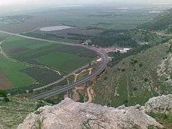
viewed from above southward
| km | Location | Name | Type | Meaning | Road(s) Crossed |
|---|---|---|---|---|---|
| ↓Beersheba Municipal Boundary↓ | |||||
| Hebron Road | |||||
| 0 | Beersheba | |
(David Hacham Blvd.) | ||
| 0.3 | Industrial Zone | |
Nordau St., Rothschild Blvd. | ||
| 0.4 | Industrial Zone | |
Dekel St. | ||
| 0.4 | Industrail Zone | |
HaNagarim St. | ||
| 0.7 | Industrial Zone | |
HaTahana St. | ||
| 0.8 | Industrial Zone | |
HaNagarim St. | ||
| 0.9 | Industrial Zone | |
Shazar Blvd. | ||
| 1 | Industrial Zone | |
Pinhas HaHotzev St. | ||
| 1.2 | Industrial Zone | |
Yosef HaBurska'i St. | ||
| 1.5 | Shopping District, Industrial Zone |
|
Heil HaHandasa St., Yitzhak Nafaha St. | ||
| 2.4 | Industrial Zone | |
Saadia Malal Blvd. | ||
| 2.4 | Industrial Zone | |
David Ben-Gurion Blvd. | ||
| 2.6 | Machteshim Industrial Zone |
|
Avraham Ben Ami St. | ||
| 3.5 | Beersheba | צומת חטיבת הנגב (Hativat HaNegev Junction) |
|
Negev Brigade | Ben Tzion Carmel Blvd., |
| ↑Beersheba Municipal Boundary↑ | |||||
| 4.3 | Omer, Tel as-Sabi |
צומת תל שבע (Tel Sheva Junction) |
|
Hill of 'Seven' or 'Oath' | Tel Sheva Rd., |
| 5.7 | Omer | |
Tamar St. | ||
| 5.9 | Omer Industrial Park |
|
Omrim St. | ||
| 7.3 | Omer | |
Tapuah St. | ||
| 9.9 | Tarabin al-Sane'/Umra, Umm Batin |
|
local road | ||
| 11 | Abu Sabit, al-Sayyid |
|
local road | ||
| 13.1 | צומת שוקת (Shoket Junction) |
|
Water Trough | | |
| 13.2 | צומת שוקת (Shoket Junction) |
|
| ||
| 14.5 | Carmit (city under construction) |
|
local road | ||
| 15.7 | Meitar | מחלף מיתר (Meitar interchange) |
|
Cord | Hebron Blvd. |
| 16.2 | Kibbitz Kramim | צומת כרמים (Kramim Junction) |
|
Vineyards | local road |
| 17.6 | צומת סנסנה (Sansana Junction) |
|
(Biblical) Palm Tree | local road to Sansana | |
| 18.5 | Green Line | ||||
| 18.5 | Green Line, Meitar Terminal[6][7] |
|
entrance to passenger terminal and cargo transfer station | ||
| 18.6 | Meitar Security Checkpoint | ||||
| | |||||
| 18.7 | Green Line, Meitar Terminal |
|
Teneh Omarim, ad-Dhahiriya, Meitar Terminal | ||
| Dhahiriya Bypass | |||||
| 27 | Meitarim Industrial Park | צומת שמעה (Shim'a Junction) |
|
named after minor biblical figure |
|
| 27.1 | Shim'a (Yonadav) | |
local road | ||
| 28 | Mitzpe Eshtemoa | |
local road | ||
| 31.9 | as-Simya, as-Samu' |
|
| ||
| 35.4 | Otniel | |
local road | ||
| 35.3 | Otniel, Karma |
צומת עתניאל (Otniel Junction) |
|
named after biblical judge |
local road |
| Otniel-Hagai Road | |||||
| 33.9 | Karma | |
local road | ||
| 37 | Deir Razih | |
local road | ||
| 37.9 | Tarrama | |
| ||
| 38.8 | al-Hijra, Hadab al-Fawwar, al-Fawwar |
|
| ||
| 41.2 | South Hebron | |
local road | ||
| Hebron Bypass | |||||
| 41.4 | Beit Hagai | |
local road | ||
| 45.7 | South Hebron | |
local road, entrance to Industrial Park | ||
| 47.7 | |
| |||
| 49.1 | Bani Naim | |
local road | ||
| 50.9 | Kiryat Arba | |
local road, open during Jewish festivals for overflow traffic | ||
| 52.2 | Kiryat Arba | |
Views of Mamre St. | ||
| 55 | Beit Einun, Khirbat Zayta, Hebron |
|
local road | ||
| 55.9 | Hebron, Halhul |
צומת העוקפים (HaOkfim Junction) |
|
the bypasses | |
| Halhul bypass | |||||
| 59.2 | Halhul, Sa'ir |
|
| ||
| 62.6 | Halhul | |
local road | ||
| Halhul-Arrub Road | |||||
| 62.8 | Karmei Tzur | |
local road | ||
| 64.9 | Beit Ummar | |
| ||
| 66.8 | Mu'askar al-Arrub, al-Arrub |
|
local road | ||
| Gush Road | |||||
| 69.5 | Alon Shvut, Beit Fajjar |
צומת גוש עציון (Gush Etzion Junction) |
|
Etzion Bloc | |
| 70.7 | Efrat (south) | צומת אפרת דרום South Efrat Junction |
|
| |
| 72 | Elazar | |
local road | ||
| 73.3 | Neve Daniel | |
local road | ||
| 75.8 | al-Khader, Efrat (north) |
צומת שיירות עציון (Shayarot Etzion Junction) |
|
Etzion Convoys | local road |
| ↑green license plates rejoin Highway 60 south from al-Khader↑ | |||||
| Bethlehem Bypass | |||||
| 78.4 | al-Khader, Husan |
צומת אל חאדר (al-Khader Junction) |
|
The Green One | to Beitar Illit, Tzur Hadassah |
| 79.5 | Beit Jala | |
al-Amal St. | ||
| green license plates continue to Route 60 north via al-Khader or Beit Jala, local roads, Routes 398, 417 and 437 | |||||
| 79.6 | Tunnels / Patriarch's Way Security checkpoint | ||||
| Tunnels Road | |||||
| 80.6 | Beit Jala | מנהרת רפאים (Refaim Tunnel) 2 lanes, 900 m. |
|
'Giants' or 'Ghosts' | |
| 82.2 | Beit Jala, Gilo |
גשר גילה (Gilo Bridge) 2 lanes, 400 m. |
|
||
| 82.6 | Gilo | מנהרת גילה (Gilo Tunnel) 2 lanes, 250 m. |
|
||
| ↓Jerusalem Municipal Boundary↓ | |||||
| 83.3 | Gilo | צומת המנהרות (HaMinharot Junction) |
|
Tunnels | HaRosmarin St |
| Planned[8] | |||||
| Gilo | מחלף רוזמרין (Rosmarin Interchange) |
|
Rosemary | HaRosmarin St., (Begin Boulevard) | |
| HaRosmarin St | |||||
| 83.5 | Beit Safafa, Tantur |
|
A-Safa St., entrance to Tantur | ||
| Hebron Road | |||||
| 83.6 | Beit Safafa, Tantur |
צומת טנטור (Tantur Junction) |
|
Hilltop | Hebron Road, south to Bethlehem |
| 83.7 | Mar Elias Monastery | |
local road | ||
| 84.7 | Har Homa | |
(Shmuel Meir Blvd.) | ||
| 84.9 | Givat HaMatos, Beit Safafa |
|
local road | ||
| 84.9 | Green Line | ||||
| 85.2 | Talpiot | |
Derech Beit Lehem | ||
| 85.5 | Talpiot | |
HaUman St, Asher Wiener St. | ||
| 86.2 | Talpiot | |
HaTnufa St. | ||
| 86.4 | Talpiot | |
Dostrovsky St. | ||
| 86.7 | Talpiot | כיכר יצחק לוי (Yitzhak Levi Square), צומת הבנקים (Banks Junction) |
|
Rivka St., Ein Gedi St. | |
| 87 | Baka, Talpiot |
|
Yehuda St., Daniel Yanovsky St. | ||
| 87.3 | Baka | |
Queen Esther St. | ||
| 87.6 | Baka | |
Miriam HaHashmonait St. | ||
| 87.7 | Talpiot | כיכר בולגריה (Bulgaria Square) |
|
Hanoch Albeck St. | |
| 87.8 | Abu Tor | |
Naomi St. | ||
| 88 | Abu Tor | |
Gihon St. | ||
| 88.2 | Abu Tor | |
Aminadav St. | ||
| 88.4 | Abu Tor | כיכר יוסף נבון (Yosef Navon Square) |
|
David Remez St., HaMefaked St. | |
| 89 | Old City | |
Ma'ale HaShalom St. | ||
| Hativat Yerushalayim Street | |||||
| 89.4 | Old City, Jaffa Gate |
|
Omar ibn il-Khatab St. entrance to Old City | ||
| Jaffa Road | |||||
| 89.5 | Old City, Jaffa Gate |
כיכר שער יפו (Jaffa Gate Square) |
|
Yitzhak Kariv St. Mamilla Mall | |
| 89.9 | מנהרת הצנחנים (HaTzanhanim Tunnel) 2 lanes, 600m. |
|
Paratroopers | ||
| HaTzanhanim Street | |||||
| 90 | Old City, New Gate |
|
New Gate St. entrance to Old City | ||
| 90.05 | Saint-Louis Hospital (Notre Dame de Terre Sainte) |
|
entrance to hospital | ||
| 90.2 | Old City, Musrara |
כיכר אברהם הלפרין (Avraham Halperin Square) (southbound only) |
|
named for Avraham Halperin |
Ha Ayin Het St |
| 90.4 | Old City, Damascus Gate |
|
Sultan Suleiman St. | ||
| Heil HaHandasa Street | |||||
| 90.5 | Tunnel end | |
|||
| 90.6 | Musrara, Mas'udiyya |
|
HaNevi'im St., Antarah ibn Shaddad St., Light Rail Station | ||
| 90.75 | Mas'udiyya | |
Naomi Kis St., Ibn al-'As St. | ||
| 90.8 | Musrara, Mas'udiyya |
(southbound only) | |
HaHoma HaShlishit St. | |
| 90.85 | Musrara | (southbound only) | |
Micel Leib Katz St. | |
| 90.9 | Mas'udiyya | (northbound only) | |
Pikud HaMerkaz St. | |
| 91 | Beit Yisrael, American Colony |
כיכר פיקוד הצפון (Pikud HaMerkaz Square) |
|
Central Command | Shivtei Yisrael St., Saint George St., Light Rail Station |
| Haim Bar-Lev Street | |||||
| 91.2 | Beit Yisrael | כיכר מנדלבאום (Mandelbaum Square) (southbound only) |
|
Named for Mandelbaum Gate |
Shmuel HaNavi St. |
| 91.3 | Beit Yisrael, American Colony |
|
Moshe Zaks St., Pierre van Paassen St. | ||
| 91.6 | Green Line | ||||
| 91.7 | Arzei HaBira, Sheikh Jarrah |
|
Shimon HaTzadik St., Light Rail Station | ||
| 92.3 | Ma'alot Dafna, Sheikh Jarrah |
|
Zalman Shragai St., Clermont-Ganneau St. | ||
| 92.6 | Givat HaMivtar, French Hill |
כיכר מיינרצהאגן (Meinertzhagen Square) |
|
named after Richard Meinertzhagen |
Levi Eshkol Blvd., Hebrew University Blvd. ( Light Rail Station |
| 93.2 | Giv'at HaMivtar, French Hill |
|
Sheshet HaYamim Blvd, Shuafat Road, HaHagana Blvd., Light Rail Station | ||
| Uzi Narkis Road | |||||
| 93.5 | Shuafat, French Hill |
מחלף שער מזרח (Sha'ar Mizrah Interchange) |
|
East Gate | |
| 95.1 | Shuafat, Pisgat Zeev |
|
Yekutiel Adam Blvd. | ||
| 96.1 | Beit Hanina, Pisgat Zeev |
|
Hamid Shomaan St. (Jerusalem Road 20), Amihai "Gidi" Feiglin St. (Sayeret Duchifat Blvd.) to | ||
| Musa Peled Street | |||||
| 97.4 | Beit Hanina, Pisgat Zeev, Neve Ya'akov |
כיכר מגיני עטרות ונווה יעקב (Maginei Atarot & Neve Ya'akov Square) |
|
defenders of Atarot & Neve Ya'akov |
Beit Hanina Rd. Neve Ya'akov Blvd. |
| Ramallah Road | |||||
| Shikunei Nuseiba, Dahiat al-Barid |
14 local streets | ||||
| 98.9 | Atarot | |
Bir Nabala Rd. | ||
| 99.4 | Atarot | |
Aviation Rd. | ||
| 100.4 | Qalandia Atarot Airport |
|
to | ||
| ↑Jerusalem Municipal Boundary↑ | |||||
| yellow license plates continue to Highway 60 north via Sayeret Duchifat Blvd. and Route 437 | |||||
| 100.5 | Qalandia Security checkpoint[9] | ||||
| green license plates continue to Highway 60 south via Routes 437, 417, 398 and local roads, Beit Jala or al-Khader | |||||
| 100.6 | Kafr 'Aqab | |
Ramallah Road | ||
| Ramallah Bypass | |||||
| 101.9 | Ar-Ram, Jaba' | |
Bir Nabala Rd | ||
| ↓yellow license plates rejoin Highway 60 north from Route 437↓ | |||||
| 104.4 | Geva Binyamin | |
Adam Blvd. | ||
| 105.1 | Sha'ar Binyamin Industrial Park |
|
local road | ||
| 106.1 | Mikhmas | |
local road | ||
| 106.2 | Kokhav Ya'akov, Psagot |
|
local road | ||
| 107.3 | Ma'ale Mikhmas | |
to | ||
| 109.8 | Migron (ordered removed by Apr 2012)[10] |
|
local road | ||
| 112.4 | al-Bireh, Beit El, Giv'at Asaf, Burqa, Beitin |
צומת אסף (Asaf Junction) |
|
named after Asaf Hershkovitz |
|
| 113.4 | Deir Dibwan | |
local road | ||
| 118.1 | Ofra | צומת עפרה (Ofra Junction) |
|
named after biblical town[11] |
HaMiyasdim St. |
| 118.3 | Ein Yabrud, Yabrud, Silwad |
|
| ||
| 123.1 | צומת עם 'Am Junction |
|
to Birzeit, Ateret | ||
| 124.2 | Al-Mazra'a ash-Sharqiya | |
| ||
| 127.4 | Sinjil | |
| ||
| 129 | Sinjil | |
local road | ||
| 129.4 | Turmus Ayya | |
local road | ||
| 131.3 | Shilo | צומת שילה (Ofra Junction) |
|
named after biblical town[12] |
local road |
| Wadi ash-Sha'ir Road | |||||
| 135.1 | Eli | |
Elkana Rd. | ||
| 135.3 | Eli | |
14th of Elul St. | ||
| 136.9 | Ma'ale Levona | |
local road | ||
| 137.9 | Al-Lubban ash-Sharqiya | |
local road | ||
| 140.3 | Qabalan | |
| ||
| 140.1 | As-Sawiya | |
local road | ||
| 142.7 | Rechelim, Ariel |
|
local road | ||
| 145.1 | Kfar Tapuach | צומת תפוח (Tapuah Junction) |
|
Apple | |
| Huwara Road | |||||
| 147.8 | Beita | |
local road | ||
| 147.9 | Huwara | |
local streets | ||
| 148.4 | Huwara | |
Road 5076, local streets | ||
| 148.6 | Huwara | |
local road to Odala, local streets | ||
| 149.3 | Huwara | |
local streets, to Nablus, Itamar, Elon Moreh | ||
| Nablus Bypass | |||||
| 151.2 | Yitzhar, Burin |
|
local road | ||
| 160.9 | Sarra | |
local road to Nablus | ||
| 161.1 | Jit | צומת ג'ית (Jit Junction) |
|
| |
| 163.9 | Kedumim Local Council, Bar-On Industrial Park |
|
local road | ||
| 167.2 | |
| |||
| 167.9 | Shavei Shomron | |
local road | ||
| | |||||
| 169.9 | Deir Sharaf | צומת שומרון (Shomron Junction) |
|
Samaria | local road |
| 169.8 | An-Naqura | |
local road | ||
| 171 | Sebastia | |
| ||
| 171.7 | Sebastia | |
local road | ||
| 177.1 | Burqa | |
local road | ||
| 178.4 | Bazariya | |
local road | ||
| 179.1 | Homesh (evacuated) | |
| ||
| 180.3 | Silat ad-Dhahr | |
local streets | ||
| 182.5 | Fandaqumiya | |
local streets | ||
| 183.9 | Jaba | |
local road | ||
| 184 | Jaba | |
Sanur, Meithalun | ||
| 184.8 | Sa-Nur (evacuated) | |
| ||
| 186 | Ajjah | |
local road | ||
| 187.5 | Anzah | |
local road | ||
| 189.6 | Zawiya | |
local road | ||
| 191.5 | |
local road | |||
| 194.2 | Mirka | צומת דותן (Dotan Junction) |
|
named after ancient city |
|
| | |||||
| | |||||
| Route 588[2] | |||||
| 194.5 | Tel Dothan | |
local road | ||
| 195.2 | Bir al-Basha | |
6 local streets | ||
| ↓Palestinian Authority Area A↓ | |||||
| 199.7 | Ash-Shuhada, Qabatiya | צומת קבאטיה (Qabatiya Junction) |
|
local road | |
| 203.2 | Jenin | |
22 local streets | ||
| 207.2 | Dahiyat Sabah al-Kheir | |
11 local streets | ||
| ↑Palestinian Authority Area A↑ | |||||
| Jalamah Road[2] | |||||
| 209.8 | Jalamah | |
to Zababdeh, Wadi ad-Dabi', Kadim (evacuated), Ganim (evacuated) | ||
| 210.2 | Jalamah | |
6 local streets | ||
| 211.2 | Green Line, Jalamah Terminal[13][14] |
|
entrance to passenger terminal and cargo transfer station | ||
| 211.4 | Green Line | ||||
| | |||||
| 211.5 | Jalamah Security checkpoint | ||||
| | |||||
| 211.8 | Green Line, Jalamah Terminal, Muqeible |
|
entrance to passenger terminal and cargo transfer station, local road to Muqeible | ||
| 212.7 | Magen Shaul | |
local road | ||
| 212.9 | Sandala | |
2 local roads | ||
| 214.3 | Gan Ner | |
local road | ||
| 216 | Prazon | |
local road | ||
| 217.2 | Yizre'el, Avital |
צומת יזרעאל (Yizre'el Junction) |
God Sows | | |
| ↓Afula Municipal Boundary↓ | |||||
| Jerusalem Boulevard | |||||
| 223.1 | Afula | צומת אפולה דרום מזרח (Afula Drom Mizrah Junction) |
|
South-East Afula | Menachem Begin Blvd. |
| 223.3 | Afula | |
Gilboa St. | ||
| 223.6 | Afula | |
Yehoshua Hankin St. | ||
| 223.8 | Afula | |
Ussishkin St. | ||
| 223.9 | Afula | |
Kehilat Tzion Blvd. | ||
| Yosef Sprinzak Boulevard | |||||
| 224 | Afula | |
HaNasi Weizmann Blvd., Afula Central Bus Station | ||
| HaNasi Weizmann Boulevard | |||||
| 224.1 | Afula | |
Jerusalem Blvd. | ||
| 224.3 | Afula | כיכר העצמאות (HaAtzma'ut Square) |
|
Independence | Arlozorov St. |
| 224.5 | Afula | כיכר פז (Paz Square) |
|
Moshe Sharett St., Holland St., Zalman Hod St. | |
| Hativat Teisha' Boulevard | |||||
| 224.6 | Afula | |
Zalman Shazar St. | ||
| 224.7 | Afula | |
Rimon St. | ||
| 224.8 | Afula | |
Hadasim St., Einstein Blvd. | ||
| 224.9 | Afula | |
Etrog St. | ||
| 225 | Afula | |
Tzaftzefot St., HaAvoda St. | ||
| 225.2 | Afula | צומת מכבי אש (Mikhabei Esh Junction) |
|
Firefighters | Hadarim St., HaHistadrut Blvd. |
| 225.4 | Afula | |
Yukler B'Emek Shopping Center | ||
| 226.2 | Afula | |
| ||
| ↑Afula Municipal Boundary↑ | |||||
| 226.9 | Balfouria | |
local road | ||
| 228.7 | Kfar Gid'on | |
local road | ||
| 229.2 | Jezreel Valley Regional Council, Mizra, Emek Yezreel College |
|
local road | ||
| 230 | Tel Adashim | |
local road | ||
| 230.2 | Tel Adashim | צומת עדשים (Adashim Junction) |
|
Lentils | |
| ↓Nazareth Municipal Boundary↓ | |||||
| 232.2 | Nazareth, Iksal |
מחלף איכסאל (Iksal Interchange) |
|
Chores | Marj Ibn Amer Rd. |
| 232.6 | Har HaKfitza (Mount Precipice) |
גשר רפאל איתן (Raphael Eitan Bridge) 4 lanes, 400m. |
|
||
| 233 | Har HaKfitza (Mount Precipice) |
מנהרות יצחק הרשקוביץ (Yitzhak Herskovitz Tunnels) 4 lanes, 380m. |
|
||
| 234.6 | Nazareth Industrial Zone A |
(southbound only) | |
Wadi el-Hadj St. | |
| 235.1 | Nazareth | צומת המוסכים (HaMusachim Junction) |
|
Auto Repair Shops | (HaTsiyonut Blvd.), Tawfiq Ziad St. |
References & Notes
- ↑ Eretz Binyamin: Leave politics behind - Israel Travel, Ynetnews
- 1 2 3 At the time of its designation Highway 60 was a consecutive highway, running from Beersheba to Nazareth. With the outbreak of the Al-Aqsa Intifada an IDF decree forbade Israelis from traveling on the Tel Dotan-Jenin-Jalamah section, effectively splitting Highway 60. Final designation of the highway is dependent on the final status agreement between Israel and the Palestinians.
- ↑ IDF Statement on Rt. 60 Terror Attack, 31 Aug 2010
- ↑ On the eve of the summit meeting in Washington to relaunch the direct Israeli-Palestinian negotiations, a shooting attack was carried out targeting an Israeli vehicle southeast of Hebron. Four Israeli civilians were killed. Hamas' military wing claimed responsibility; the Palestinian Authority condemned the attack, September 1, 2010, Meir Amit Intelligence and Terrorism Information Center.
- ↑ "4 Israelis shot dead in West Bank," Janine Zacharia and Samuel Sockol, September 1, 2010, Washington Post.
- ↑ "Crossing Points West Bank and Gaza Strip". Palestinian Shipper's Council. Retrieved 2014-08-22.
- ↑ "Coordination of Government Activity in the Territories - Meitar Crossing". Israel Defense Forces. Retrieved 2014-08-22.
- ↑ "Work continues on Begin Highway". Jerusalem Municipality. 2012-04-01. Retrieved 2012-08-05.(Hebrew)
- ↑ "Coordination of Government Activity in the Territories - Atarot (Kalandia) Crossing". Israel Defense Forces. Retrieved 2014-08-22.
- ↑ Chaim Levinson (2011-08-02). "Israel's Supreme Court orders state to dismantle largest West Bank outpost". Haaretz. Retrieved 2011-08-06.
- ↑ Joshua 18:23
- ↑ Judges 21:19
- ↑ "Crossing Points West Bank and Gaza Strip – Jalameh Terminal". Palestinian Shipper's Councill. Retrieved 2014-08-22.
- ↑ "Coordination of Government Activity in the Territories- Gilboa-Jalame Crossing". Israel Defense Forces. Retrieved 2014-08-22.
See also
| Wikimedia Commons has media related to B60 (Israel). |
| Roads |
| ||||||
|---|---|---|---|---|---|---|---|
| Bus operators | |||||||
| Rail transport |
| ||||||
| Sea ports | |||||||
| Aviation |
| ||||||
| Cable cars | |||||||
| By city | |||||||
| Smart cards | |||||||