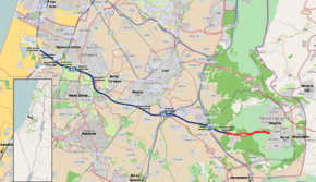
Route 431 (Israel)
| |
|---|---|
| 431 כביש | |
 | |
| Route information | |
| Length: | 23 km[1] (14 mi) |
| Major junctions | |
| West end: | Rishon LeZion (Mevo Ayalon Interchange) |
| |
| East end: | Modi'in |
| Location | |
| Major cities: | Ness Ziona, Be'er Ya'akov, Ramla |
| Highway system | |
| Highways | |


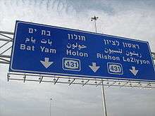
Route 431 (Hebrew: כביש 431), is a suburban freeway in the south of the Tel Aviv Metropolitan Area in Israel. The freeway connects the Ayalon Highway in the west with Highway 1 in the east. It then continues east into Modi'in as a local road.
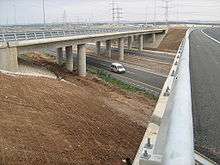
The freeway has six lanes (three in each direction) over a total length of 21 km. There is also a short Collector/Distributor system between Rishon Darom and Nes Ziona Interchanges. There are 12 interchanges along its length, 5 of them freeway to freeway interchanges. There are also 54 km of service roads, including exits and entrance ramps.
The design of the freeway includes a right of way for a double track railway in its median between Ein Ha'Kore and Modi'in and railway sections are currently operational between Be'er Yaakov and HaRishonim Interchange and between the Anava Interchange and Modi'in. The freeway and railway also cross three existing railway lines along the route and allows for a connection to two of them.
Route 431 is the first PFI project in Israel. Netivey HaYovel, a subsidiary of Danya Cebus and Africa Israel Investments Ltd., was awarded the 25 year tender to build, maintain and operate the freeway. As of February 2009, the cost of the freeway had been 2.5 billion NIS (approximately 620 million USD). Following the completion of the freeway in February 2009, the company is expecting a 200 million NIS (50 million USD) grant from the state.[2]
History
Construction started in 2005 and the road was fully opened on February 4, 2009.
A section of the highway between Mevo Ayalon Interchange and Gan Ha'Vradim Interchange was set to open on October 23, 2008, approximately 3 months ahead of schedule. However, on October 22 it was announced that the opening will be postponed for at least two weeks due to Netivey HaYovel's failure to complete the required environmental mitigation, as was the case of Jerusalem Route 9.[3] The road finally opened on November 12, after Danya Cebus agreed to place several million NIS as a guarantee that the required works will be carried out.[4]
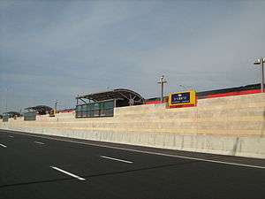
The second section between Gan Ha'Vradim Interchange and Anava Interchange opened on the evening of February 4, 2009.[5] Although the freeway was fully opened at this point, there was some work left around it. At Ein Ha'Kore, the Road 4311 bridge over Highway 42 has not been completed leaving a traffic light at what was planned to be a grade-separated freeway segment, and at Nesharim Interchange the western exits have yet to open. The exits at Nesharim opened on May 20, 2009, and the bridge at Ein Ha'Kore opened on June 29, 2009. All other works along the freeway were finished by September 2009.
The local road in Modi'in was partially opened together with the freeway, initially with one lane in each direction. Construction on this section was completed in November 2009, providing a limited-access, multiple lane, grade-separated highway all the way from the Ayalon Highway near the Mediterranean coast to the entrance to Modi'in.
Starting in May 2010, electronic signs for a traffic control system were installed along the freeway. As of July 2010, the system is not yet fully active.
Interchanges
| km | Name | Type | Meaning | Location | Road(s) Crossed |
|---|---|---|---|---|---|
| 0 | מחלף מבוא איילון (Mevo Ayalon Interchange) |
|
Ayalon Gateway | Rishon LeZion | (northbound) |
| 1 | מחלף קרית ראשון (Kiryat Rishon Interchange) |
|
named after neighborhood | Rishon LeZion | Mota Gur St. |
| 2 | מחלף ראשון דרום (Rishon Darom Interchange) |
|
South Rishon | Rishon LeZion | (southbound) |
| 3 | מחלף עין הקורא (En Ha'Kore Interchange) |
|
presumed biblical location (possibly incorrect) The Korei Spring[6] |
Rishon LeZion | (northbound) |
| 5 | מחלף הראשונים (HaRishonim Interchange) |
|
named after neighborhood and railway station ult. HaRishonim |
Rishon LeZion Ness Ziona |
(Herzl St.) |
| 6 | מחלף נס ציונה (Nes Ziona Interchange) |
|
Banner to Zion | Ness Ziona Rishon LeZion Be'er Ya'akov |
|
| Planned | |||||
| 9 | מחלף רמלה מערב (Ramla Ma'arav Interchange) |
|
West Ramla | Ramla | |
| 11 | מחלף רמלה דרום (Ramla Darom Interchange) |
|
South Ramla | Ramla | |
| 14 | מחלף נשרים (Nesharim Interchange) |
|
Eagles named after nearby Nesher Factory & ult. Rambam, the great Eagle |
Ramla | |
| Planned | |||||
| 17 | מחלף רג"מ (RaGaM Interchange) |
|
named after location of planned industrial park bordering 3 areas: Ramla, Gezer & Modi'in |
planned RaGaM Industrial Park | local road |
| 20 | מחלף ענבה (Anava Interchange) |
|
Berry named after Anava (Anabe) Stream |
Kfar Shmuel | |
| 22.8 | מחלף פאתי מודיעין (Pa'atei Modi'in Interchange) |
|
Outskirts of Modi'in | Pa'atei Modi'in Railway Station Yishpro Shopping Center |
HaMal'achut Blvd. |
| 24.4 | eastbound only | |
Yishpro Shopping Center | HaHamam Blvd. | |
| 26.4 | |
Modi'in | Yehuda HaMaccabee St. | ||
| 27.6 | |
Modi'in | Yitzhak Rabin Blvd. HaHashmona'im Blvd. | ||
References
- ↑ Dorfman, Idan (2008-03-04). "Danya Cebus Fell 20% Following Losses on Road 431". Mamon. Yedioth Ahronoth. p. 19.
- ↑ "Route 431 opens tonight" (in Hebrew). Globes. Retrieved 2008-02-04.
- ↑ "Route 431 will not open tomorrow" (in Hebrew). Globes. Retrieved 2008-10-23.
- ↑ "Western section of Route 431 opened" (in Hebrew). Globes. Retrieved 2008-11-12.
- ↑ "Route 431 opened tonight" (in Hebrew). mcity. Retrieved 2009-02-04.
- ↑ Judges 15:19
External links
| Roads |
| ||||||
|---|---|---|---|---|---|---|---|
| Bus operators | |||||||
| Rail transport |
| ||||||
| Sea ports | |||||||
| Aviation |
| ||||||
| Cable cars | |||||||
| By city | |||||||
| Smart cards | |||||||
Coordinates: 31°54′35″N 34°52′56″E / 31.90972°N 34.88222°E