Highway 38 (Israel)
| |
|---|---|
|
כביש 38 Kvish Shloshim v'Shmoneh | |
 | |
| Route information | |
| Length: | 29 km (18 mi) |
| Major junctions | |
| South end: | Nechusha Junction |
| |
| North end: | Sha'r HaGai Interchange |
| Location | |
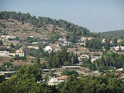
| Major cities: | Beit Shemesh |
| Highway system | |
| Highways | |

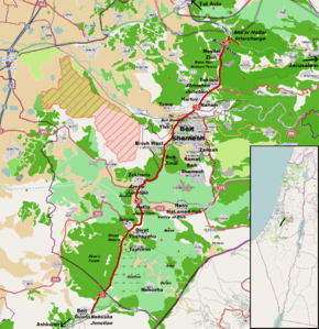
Highway 38 is an arterial road in the low plains of Judea in Israel. It serves as the main access route to Beit Shemesh and as a main north-south route in the region. Along the route are many nature preserves and archeological sites.
Route
Highway 38 travels in a north-northeast direction as it winds through the western foothills of the Judaean Mountains from Highway 35 at Beit Guvin Junction to Highway 1 at Sha'ar HaGai Interchange. Except for a small section adjacent to Beit Shemesh, the road is a two-lane, undivided highway. Along many stretches, it follows small valleys formed by northward turns of westward streams emanating from the mountains to the east, notably, the Yoresh, Hakhlil, Yarmut and Kisalon Streams. Between the stream valleys and north of Eshtaol the road rises and falls as it crosses the many east-west ridges.
History
From biblical times the road is mentioned in 1Samuel 6:12 as the route taken by the Philistines returning the Ark of the Covenant to the Israelites in Beth-Shemesh.
During the Roman Era, the road was an important route as evidenced by milestones found near Givat Yeshayahu as part of the road from Ashkelon via Highway 35 to Beit Guvrin, northward along Highway 38, then westward via the Elah Valley to Jerusalem.[1]
In 1948, the Latrun section of Highway 1 was taken over by Jordan. Traffic between Tel Aviv and Jerusalem was diverted to a new route called "Kvish HaGvura" (Road of Bravery) of which Highway 38 served as the connection between Highway 44 at Shimshon Junction and Highway 1 at Sha'ar HaGai. This section of the road was straightened and widened in 1960.[2]
For many years, an expansion of Highway 38 was envisioned. In 2010, the Mayor of Beit Shemesh raised the problem of the road between Sha'ar HaGai and Beit Shemesh calling it a "bloodbath" due to the many fatal traffic accidents. The Ministry of Transport claimed that the upgrade would take until 2013.[3] However, plans were pushed back several times because of budgetary constraints. In the meantime, as of 2013, a short section of the road between Beit Shemesh and Beit Jamal has been widened and junctions have been upgraded.[4]
Future
At the end of 2012, the National Roads Company of Israel published tenders to upgrade the road creating a divided highway with two lanes in each direction between Beit Shemesh and Sha'ar HaGai. The government granted approval on 6 June 2013. The approval was made through the special "Housing Cabinet" since the road's expansion is a condition for plans to build an additional 20,000 apartments and homes in Beit Shemesh.[5]
A trumpet interchange will be created at Shimshon Junction and diamond interchanges at Naham/Hartuv, Eshtaol, Mesilat Zion, the Burma Road and the Sha'ar HaGai Caravansserai. A wildlife crossing (ecological bridge) will be built near Mesilat Zion and the road will be raised to overpass the railway tracks at Beit Shemesh. The estimated completion date is now 2016 and the cost will reach 900M Shekels.[5][6][7]
Junctions (South to North)


| km | Name | Type | Meaning | Location | Road(s) Crossed |
|---|---|---|---|---|---|
| 0 | צומת נחושה (Nehusha Junction) |
|
Steadfast | Beit Guvrin | |
| 4.7 | צומת מושב נחושה (Moshav Nehusha Junction) |
|
named after location | Nehusha | local road |
| 7.3 | |
Mitzpe Mesu'a, Adullam Grove Nature Reserve, Hurbat Atari Archeological Site, Hurbat Burgin Archeological Site |
local roads | ||
| 7.8 | צומת שריגים (Srigim Junction) |
|
Shoots | Le-On, Givat Yeshayahu, Tzafririm |
|
| 8.4 | |
Givat Yeshayahu | local road | ||
| 9.3 | |
Srigim Cemetery | local road | ||
| 10.1 | צומת האלה (HaEla Junction) |
|
Named after biblical location Valley of the Terebinth[8] |
Valley of Elah, Netiv HaLamed-Heh, Sha'arayim Archeological Site, Socoh Archeological Site |
|
| 11.9 | צומת עזקה (Azeka Junction) |
|
Named after biblical location[9] |
Azekah Archeological Site, Britannia Park |
|
| 12.7 | צומת זכריה (Zekharya Junction) |
|
Named after biblical character Zechariah |
Zekharia | local Road |
| 15.2 | צומת רמת בית שמש (Ramat Bet Shemesh Junction) |
|
Beit Shemesh Heights | Beit Shemesh | Nahal Tze'elim St. |
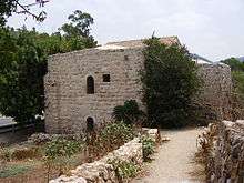
| 16.7 | צומת בית ג'מאל (Beit Jamal Junction) |
|
Named after biblical character Gamaliel |
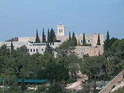
Beit Jimal Monastery | local Road |
| 17.2 | צומת ברוש (Brosh Junction) |
|
Cypress | Brosh West Industrial Area |
Virginia St. |
| 18.6 | צומת בית שמש מערב (Bet Shemesh Ma'arav Junction) |
|
West Beit Shemesh | Beit Shemesh | Yehuda Ben Ze'ev Blvd. |
| 18.7 | צומת ישעי (Yishi Junction) |
|
My Salvation | Yish'i | local Road |
| 19.1 | |
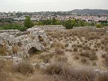
Tel Beit Shemesh Archeological Site |
local road | ||
| 19.9 | צומת צרעה (Tzora Junction) |
|
Named after biblical location[10] |
Tzora | |
| 20.2 | צומת בית שמש (Bet Shemesh Junction) |
|
House of the Sun | Beit Shemesh | Yigal Allon Blvd. |
| 20.4 | Railway Crossing 2 tracks |
|
Beit Shemesh | ||
| 20.5 | (northbound only) | |
Beit Shemesh | filling station | |
| 20.9 | |
Beit Shemesh | ( (Beit Shemesh Rd 10)[11] | ||
| 21.2 | |
Hartuv Industrial Area B |
local road | ||
| 21.4 | צומת נחם (Naham Junction) |
|
Named after biblical character Naham[12] |
Naham, Sorek/Nesher Industrial Park, Mateh Yehuda Regional Council |
local road |
| 22.1 | צומת הרטוב (Hartuv Junction) |
|
Mount of Goodness | Hartuv Industrial Area A |
HaTa'asiya St. |
| 22.7 | |
Eretz HaHaim Cemetery, Naham Cemetery |
local road | ||
| 23.2 | צומת שמשון (Shimshon Junction) |
|
Named after biblical character Samson |
Eshtaol | |
| 23.5 | (northbound only) | |
Eshtaol | filling station | |
| 23.8 | צומת אשתאול (Eshtaol Junction) |
|
Named after biblical location[13] |
Eshtaol | Nahal Adorayim St., |
| 26.3 | צומת מסילת ציון (Mesilat Ziyon Junction) |
|
Track of Zion | Mesilat Zion | Cochin St. |
| 27.7 | (southbound only) | |
Mesilat Zion | Malabar St. | |
| 28.4 | (southbound only) | |
Mesilat Zion | filling station | |
| 28.6 | צומת דרך בורמה (Burma Road Junction) |
|
Burma Road, Machal Memorial,[14] Rabin Park National Forest |
local road | |
| 28.9 | מחלף שער הגיא (Sha'ar HaGai Interchange) |
|
Gate of the Valley | Sha'ar HaGai | |
| 29.2 | (from within Shaa'ar HaGai Interchange) |
|
Sha'ar HaGai Caravanserai (Historic Preserve) |
entrance road |
References
- ↑ "Valley of Elah - Roman Road". biblewalks.com. Retrieved 2011-12-09.
- ↑ "Fixing the Eshta'ol-Sha'ar HaGai Road". Historical Jewish Press. Retrieved 2011-12-07.(Hebrew)
- ↑ Koby Yeshayahou (2010-11-10). "Transport official: Road 38 work to last until 2013". Globes. Retrieved 2013-06-06.
- ↑ "Highway 38 - between Beith Shemesh and Bit Jamal". National Roads Company of Israel. Retrieved 2013-08-13.(Hebrew)
- 1 2 David Lev (2013-06-06). "Road 38 to Beit Shemesh to be Expanded; 20,000 Homes to be Built". Arutz Sheva. Retrieved 2013-06-06.
- ↑ "Tender for Highway 38 upgrade to be released immediately". National Roads Company of Israel. Retrieved 2011-12-07.(Hebrew)
- ↑ "Highway 38 - between Sha'ar HaGai and Beit Shemesh". National Roads Company of Israel. Retrieved 2011-12-07.(Hebrew)
- ↑ 1Samuel 17:19
- ↑ 1Samuel 17:1
- ↑ Judges 16:31
- ↑ "Road 10 - Beit Shemesh Bypass". National Roads Company of Israel. Retrieved 2011-12-07.(Hebrew)
- ↑ 1Chronicles 4:19
- ↑ Judges 16:31
- ↑ "Machal1947-9 - Mahal - History". Mahal IDF Volunteers Org. Retrieved 2011-12-09.
See also
| Roads |
| ||||||
|---|---|---|---|---|---|---|---|
| Bus operators | |||||||
| Rail transport |
| ||||||
| Sea ports | |||||||
| Aviation |
| ||||||
| Cable cars | |||||||
| By city | |||||||
| Smart cards | |||||||
Coordinates: 31°42′06″N 34°56′53″E / 31.70167°N 34.94806°E