Srigim
| Srigim | |
|---|---|
 | |
 Srigim | |
| Coordinates: 31°40′38.99″N 34°56′7.07″E / 31.6774972°N 34.9352972°ECoordinates: 31°40′38.99″N 34°56′7.07″E / 31.6774972°N 34.9352972°E | |
| District | Jerusalem |
| Council | Mateh Yehuda |
| Founded | 1960 |
| Founded by | Moshavniks |
| Population (2015)[1] | 1,032 |
| Website | sarigim.org.il |
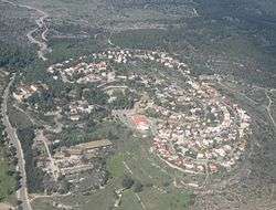
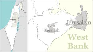
Srigim (Hebrew: שריגים. lit. Shoots), also known as Li On (Hebrew: לִי אוֹן), is a communal settlement in central Israel. Located to the south of Beit Shemesh. It falls under the jurisdiction of Mateh Yehuda Regional Council. In 2015 it had a population of 1,032. It borders the British Park forest and the biblical Elah Valley where David fought Goliath.
History
The village was established in 1960 by residents of moshavim in the region, and was planned to become a regional centre. It was named after grapevines, which are common in the area. The land had previously belonged to the depopulated Arab village of 'Ajjur.[2]
In 1996 Srigim was enlarged to include 200 families who sought to turn it into an ecological village. It boasts dozens of artists and hosts an arts fair twice a year. It has a boutique winery, a microbrewery[3] and an olive oil mill.
Notable residents
References
- ↑ "List of localities, in Alphabetical order" (PDF). Israel Central Bureau of Statistics. Retrieved 16 October 2016.
- ↑ Khalidi, Walid (1992). All That Remains: The Palestinian Villages Occupied and Depopulated by Israel in 1948. Washington D.C.: Institute for Palestine Studies. p. 207. ISBN 0-88728-224-5.
- ↑ Gilad, Moshe (30 July 2012). "Along the Judean hills, beer is the new wine". Haaretz. Retrieved 8 September 2012.
- ↑ Israel Revisited The Washington Post, 10 March 2007
External links
- Village website (Hebrew)
- Srigim Winery (Hebrew)
- Srigim Brewery (Hebrew)