Herr's Mill Covered Bridge
| Herr's Mill Covered Bridge | |
|---|---|
 | |
| Coordinates | 40°00′35″N 76°09′44″W / 40.0098°N 76.1622°WCoordinates: 40°00′35″N 76°09′44″W / 40.0098°N 76.1622°W |
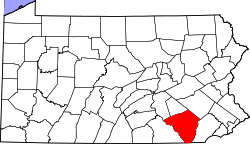
| Locale | Lancaster County, Pennsylvania, United States |
| Other name(s) | Soudersburg Bridge |
| Characteristics | |
| Design | double span, double Burr arch truss |
| Total length | 178 feet (54.3 m) |
| History | |
| Constructed by | Joseph Elliot and Robert Russell |
| Construction begin | 1844 |
 | |
 | |
The Herr's Mill Covered Bridge is a covered bridge that spans Pequea Creek in Lancaster County, Pennsylvania, United States.[1] It is also sometimes known as Soudersburg Bridge.[2]
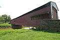
The bridge has a double span, wooden, double Burr arch trusses design. It is painted red on the outside, the traditional color of Lancaster County covered bridges. Both approaches to the bridge are painted in the traditional white color.
The bridge's WGCB Number is 38-36-21. In 1980 it was added to the National Register of Historic Places as structure number 80003537.[3] It is located at 40°0′35.4″N 76°9′43.8″W / 40.009833°N 76.162167°W (40.00983, -76.16217).[4] It is located in Paradise Township on Ronks Road 0.4 km (0.25 mi) south of U.S. Route 30 to the east of Lancaster city.[1]
History
Herr's Mill Covered Bridge was built in 1844 by Joseph Elliot and Robert Russell at a cost of $1787.[5] It has a double-span, double-arch Burr arch truss construction. In 1875 the bridge was rebuilt by James C. Carpenter at a cost of $1860.[1] The bridge was later bypassed by a new concrete bridge and is now on the private property of the Mill Bridge Village Camping Resort. Owner Brian Kopan was quoted as saying "The bridge is in fine condition. We’re hoping to keep it as it is."[6]
Dimensions
Gallery
 The side of the bridge showing part of the main road to the left and Herr's Mill to the right
- Another picture of the same side
 The other side of the bridge
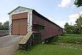

 A horse and buggy going past the bridge
See also
References
- 1 2 3 "Herr's Mill Covered Bridge". Lancaster County Pennsylvania Dutch Country Official Visitors Center. Pennsylvania Dutch Convention & Visitors Bureau. 2006. Retrieved 2006-07-07.
- ↑ "The Covered Bridges of Lancaster County". Lancaster County, PA Government Portal. County of Lancaster, Pennsylvania. 2001-11-09. Retrieved 2006-07-07.
- ↑ "PENNSYLVANIA - Lancaster County". National Register of Historic Places. Retrieved 2007-03-20.
- ↑ Travis, Dale. "38-36-21". Round Barns & Covered Bridges. Retrieved 2006-08-08.
- 1 2 Dr. Roger A. McCain. "Herr's Mill Bridge". A Guide to Old Covered Bridges of Southeastern Pennsylvania and nearby areas. Retrieved 2006-08-03.
- ↑ Robinson, Ryan (2006-09-30). "Rebirth of a covered bridge?". LancasterOnline.com : News. Lancaster Newspapers. Retrieved 2006-10-01.
- ↑ Bickel, Hank (2005-06-23). "Herr Mill / Souderburg Bridge". Covered Bridges of the Northeast USA. Retrieved 2006-08-04.
- ↑ Note: Two independent sources disagree on this length. In other covered bridges, the McCain source agreed more closely with official government sources while the Bickel source seemed incorrect or perhaps just measuring a different length. In this case, the Bickel source states that the bridge length is 113 feet (34.4 m).
| Topics |   | |
|---|---|---|
| Lists by county |
| |
| Lists by city | ||
| Other lists | ||
| ||