Harvard Avenue Historic District
|
Harvard Avenue Historic District | |
 | |
  | |
| Location | Roughly bounded by Linden St., Commonwealth AVe., Harvard Ave., and Park Vale Ave., Boston, Massachusetts |
|---|---|
| Coordinates | 42°21′12″N 71°7′58″W / 42.35333°N 71.13278°WCoordinates: 42°21′12″N 71°7′58″W / 42.35333°N 71.13278°W |
| Area | 23 acres (9.3 ha) |
| Built | 1867 |
| Architect | Shepley, Rutan and Coolidge et al. |
| Architectural style | Late Victorian, Late 19th And 20th Century Revivals, et al. |
| NRHP Reference # | 00000415[1] |
| Added to NRHP | April 28, 2000 |
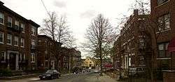
The Harvard Avenue Historic District is a historic district roughly bounded by Linden Street, Commonwealth Avenue, Harvard Avenue, and Park Vale Avenue in the Allston neighborhood of Boston, Massachusetts. Its spine is Harvard Avenue, a major north-south thoroughfare connecting Allston to points north (generally via Cambridge Street toward Cambridge), and south toward Brookline. The area underwent a population explosion in the early 20th century, and Harvard Avenue was developed roughly between 1905 and 1925 as a commercial and residential spine. Notable buildings in the district include the Allston Station building, designed by Shepley, Rutan and Coolidge, and the Harvard Avenue Fire Station.[2]
The district was listed on the National Register of Historic Places in 2000.[1]
See also
References
- 1 2 National Park Service (2009-03-13). "National Register Information System". National Register of Historic Places. National Park Service.
- ↑ "NRHP nomination for Harvard Avenue Historic District". Commonwealth of Massachusetts. Retrieved 2014-06-16.
| Topics |  | ||||||||||||||||||||||||||||||
|---|---|---|---|---|---|---|---|---|---|---|---|---|---|---|---|---|---|---|---|---|---|---|---|---|---|---|---|---|---|---|---|
| Lists by county | |||||||||||||||||||||||||||||||
| Lists by city |
| ||||||||||||||||||||||||||||||
| Other lists | |||||||||||||||||||||||||||||||
| |||||||||||||||||||||||||||||||