Hamorton Historic District
|
Hamorton Historic District | |
|
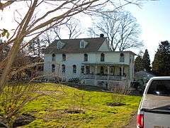
House in Hamorton Historic District, December 2009 | |
  | |
| Location | Junction of U.S. Route 1 and Pennsylvania Route 52, Kennett Township, Pennsylvania |
|---|---|
| Coordinates | 39°52′08″N 75°39′18″W / 39.86889°N 75.65500°WCoordinates: 39°52′08″N 75°39′18″W / 39.86889°N 75.65500°W |
| Area | 32.5 acres (13.2 ha) |
| Built by | Hamor, Abraham; Martin, E.William |
| Architectural style | Colonial Revival, Gothic Revival |
| NRHP Reference # | 90000704[1] |
| Added to NRHP | April 26, 1990 |
Hamorton Historic District is a national historic district located in Kennett Township, Chester County, Pennsylvania, United States. It encompasses 75 contributing buildings and 1 contributing structure in the crossroads community of Hamorton. It largely consists of a variety of stone, brick, and frame residences built between 1780 and 1930. The village was laid out in the 1830s and developed as a "company town" in the early 20th century by Pierre S. du Pont (1870–1954).[2]
It was added to the National Register of Historic Places in 1990.[1]
References
- 1 2 National Park Service (2010-07-09). "National Register Information System". National Register of Historic Places. National Park Service.
- ↑ "National Historic Landmarks & National Register of Historic Places in Pennsylvania" (Searchable database). CRGIS: Cultural Resources Geographic Information System. Note: This includes Martha Wolf and P. Maley (December 1989). "National Register of Historic Places Registration Form: Hamorton Historic District" (PDF). Retrieved 2012-12-23.
| Topics |   | |
|---|---|---|
| Lists by county |
| |
| Lists by city | ||
| Other lists | ||
| ||
This article is issued from Wikipedia - version of the 11/29/2016. The text is available under the Creative Commons Attribution/Share Alike but additional terms may apply for the media files.