Haixi Mongol and Tibetan Autonomous Prefecture
| Haixi Prefecture 海西州 · ᠬᠠᠶᠢᠰᠢ ᠶᠢᠨ ᠵᠧᠦ · མཚོ་ནུབ་ཁུལ། | |
|---|---|
| Autonomous Prefecture | |
海西蒙古族藏族自治州 ᠬᠠᠶᠢᠰᠢ ᠶᠢᠨ ᠮᠣᠩᠭᠣᠯ ᠲᠥᠪᠡᠳ ᠦᠨᠳᠦᠰᠦᠲᠡᠨ ᠦ ᠥᠪᠡᠷᠲᠡᠭᠡᠨ ᠵᠠᠰᠠᠬᠤ ᠵᠧᠦ Haixi Mongol and Tibetan Autonomous Prefecture | |
| Chinese transcription(s) | |
| • Chinese characters | 海西蒙古族藏族自治州 |
| • Hanyu pinyin | Hǎixī Měnggǔzú Zàngzú Zìzhìzhōu |
| Tibetan transcription(s) | |
| • Tibetan script | མཚོ་ནུབ་སོག་རིགས་ཆ་བོད་རིགས་རང་སྐྱོང་ཁུལ་ |
| • Wylie | Mtsho-nub Sog-rigs dang Bod-rigs rang-skyong-khul |
| • Tibetan pinyin | Conub Sogrig Poirig Ranggyong Kü |
|
| |
 Location of Haixi Prefecture in Qinghai | |
| Coordinates: 37°24′N 97°24′E / 37.4°N 97.4°ECoordinates: 37°24′N 97°24′E / 37.4°N 97.4°E | |
| Country | China |
| Province | Qinghai |
| Prefectural seat | Delingha |
| Area | |
| • Total | 325,785 km2 (125,786 sq mi) |
| Population (2010)[1] | |
| • Total | 489,338 |
| • Density | 1.5/km2 (3.9/sq mi) |
| • Major Ethnic Groups |
Han-64.95% Tibetan-12.16% Hui-11.94% Mongols-7.23% |
| Time zone | China Standard (UTC+8) |
| Postal code | 817000 |
| Area code(s) | 0977 |
| Website |
haixi |

Haixi Mongol and Tibetan Autonomous Prefecture, locally also known as Qaidam Prefecture (mong. Qaidam; tib. Caindam; chin. Chaidamu), is an autonomous prefecture occupying much of the northern tier of as well as part of the southwest Qinghai province, China. It has an area of 325,785 square kilometres (125,786 sq mi) and its seat is Delingha. The name of the prefecture literally means "west of (Qinghai) Lake."
Geladandong Mountain, the source of the Yangtze River, is located here.
History
After 1949, the People's Government of Dulan County was founded and the area was renamed Dulan Autonomous District (都兰自治区); in 1954, Dulan was renamed Haixi Mongol, Tibetan and Kazakh Autonomous District (海西蒙藏哈萨克族自治区) and in 1955, Haixi Mongol, Tibetan and Kazakh Autonomous Prefecture (海西蒙藏哈萨克族自治州). In 1963, it was renamed "海西蒙古族藏族哈萨克族自治州" (English the same, "蒙藏哈萨克族"->"蒙古族藏族哈萨克族"). In 1985, after the Kazakhs had returned to Xinjiang, it was again renamed Haixi Mongol and Tibetan Autonomous Prefecture.[2]
Demographics
As of the 2010 census, Haixi had 489,338 inhabitants, giving it a population density of 1.5 inhabitants per km².
The following is a list of ethnic groups in the prefecture, taken in the 2000 Census
| Nationality | Population | Percentage |
|---|---|---|
| Han | 215,706 | 64.95% |
| Tibetan | 40,371 | 12.16% |
| Hui | 39,644 | 11.94% |
| Mongol | 24,020 | 7.23% |
| Tu/Monguor | 5,792 | 1.74% |
| Salar | 3,569 | 1.07% |
| Dongxiang | 1,026 | 0.31% |
| Manchu | 544 | 0.16% |
| Tujia | 422 | 0.13% |
| Kazakh | 380 | 0.11% |
| Others | 620 | 0.2% |
Subdivisions
Haixi directly governs 2 county-level cities and 3 counties.
| Map | |||||||||
|---|---|---|---|---|---|---|---|---|---|
| # | Name | Hanzi | Hanyu Pinyin | Mongolian (Transcription from Mongolian) |
Tibetan | Wylie Tibetan Pinyin |
Population (2010) |
Area (km²) | Density (/km²) |
| 1 | Delingha | 德令哈市 | Délìnghā Shì | ᠳᠡᠯᠡᠬᠡᠢ ᠬᠣᠲᠠ Delekei qota |
གཏེར་ལེན་ཁ་གྲོང་ཁྱེར། | gter len kha grong khyer Dêrlênka Chongkyir |
78,184 | 27,613 | 2.83 |
| 2 | Golmud City | 格尔木市 | Gé'ěrmù Shì | ᠭᠣᠯᠮᠣᠣᠠ ᠬᠣᠲᠠ Ɣool modu qota |
ན་གོར་མོ་གྲོང་ཁྱེར། | na gor mo grong khyer Nakormo Chongkyir |
215,213 | 123,460 | 1.74 |
| 3 | Ulan County | 乌兰县 | Wūlán Xiàn | ᠤᠯᠠᠭᠠᠨ ᠰᠢᠶᠠᠨ Ulaγan siyan |
ཝུའུ་ལན་རྫོང་ | wu'u lan rdzong Wu'ulain Zong |
38,723 | 10,784 | 3.59 |
| 4 | Dulan County | 都兰县 | Dūlán Xiàn | ᠳᠤᠯᠠᠭᠠᠨ ᠰᠢᠶᠠᠨ Dulaγan siyan |
ཏུའུ་ལན་རྫོང་ | tu'u lan rdzong Tu'ulain Zong |
76,623 | 50,000 | 1.53 |
| 5 | Tianjun County | 天峻县 | Tiānjùn Xiàn | ᠲᠢᠶᠡᠨ ᠵᠢᠶᠦ᠋ᠨ ᠰᠢᠶᠠᠨ Tiyen ǰiyün siyan |
ཐེན་ཅུན་རྫོང་ | then cun rdzong Têncün Zong |
33,923 | 20,000 | 1.70 |
| 6 | Lenghu Administrative Zone | 冷湖行政区 | Lěnghú Xíngzhèngqū | ᠯᠧᠩ ᠾᠦ ᠶᠢᠨ ᠵᠠᠰᠠᠭ ᠵᠠᠬᠢᠷᠠᠭᠠᠨ ᠦ ᠵᠥᠪᠯᠡᠯ Lëng hü-yin ǰasaγ ǰaqiraγan-ü ǰöblel |
འཁྱག་མཚེའུ་སྲིད་འཛིན་ཨུ་ཡོན་ལྷན་ཁང་། | 'khyag mtshe'u srid 'dzin u yon lhan khang | 2,434 | 21,000 | 0.12 |
| 7 | Da'qaidam Administrative Zone | 大柴旦行政区 | Dàcháidàn Xíngzhèngqū | ᠶᠡᠬᠡ ᠴᠠᠢᠢᠳᠠᠮ ᠤᠨ ᠵᠠᠰᠠᠭ ᠵᠠᠬᠢᠷᠠᠭᠠᠨ ᠦ ᠵᠥᠪᠯᠡᠯ Yeke čayidam-un ǰasaγ ǰaqiraγan-ü ǰöblel |
ཚྭ་འདམ་ཆེ་བའི་སྲིད་འཛིན་ཨུ་ཡོན་ལྷན་ཁང་། | tshwa 'dam che ba'i srid 'dzin u yon lhan khang | 13,671 | 34,000 | 0.40 |
| 8 | Mangnai Administrative Zone | 茫崖行政区 | Mángyá Xíngzhèngqū | ᠮᠠᠨᠭᠨᠠᠢ ᠶᠢᠨ ᠵᠠᠰᠠᠭ ᠵᠠᠬᠢᠷᠠᠭᠠᠨ ᠦ ᠵᠥᠪᠯᠡᠯ Mangnai-yin ǰasaγ ǰaqiraγan-ü ǰöblel |
མང་ནེ་སྲིད་འཛིན་ཨུ་ཡོན་ལྷན་ཁང་། | mang ne srid 'dzin u yon lhan khang | 31,017 | 32,000 | 0.97 |

- The southwestern exclave of the Haixi Prefecture, separated from the rest of the prefecture by a "panhandle" of the Yushu Tibetan Autonomous Prefecture, is the Tanggula Town of Golmud City.
- All administrative zones; not administrative divisions registered under the Ministry of Civil Affairs.
Gallery
|

Notable Features
- Delingha City
- Qaidam Basin
- Geladandong mountain
- Headwaters of the Yangtze River
- The Baigong Pipes
Notes
- ↑ According to 2010 China National Census
- ↑ 海西州 (青海省民政厅网站).
For details, see: 海西蒙古族藏族自治州 (行政区划网站).
Further reading
- A. Gruschke: The Cultural Monuments of Tibet’s Outer Provinces: Amdo - Volume 1. The Qinghai Part of Amdo, White Lotus Press, Bangkok 2001. ISBN 974-480-049-6
- Tsering Shakya: The Dragon in the Land of Snows. A History of Modern Tibet Since 1947, London 1999, ISBN 0-14-019615-3
External links
| Regions | 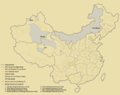 | ||||||||||||||
|---|---|---|---|---|---|---|---|---|---|---|---|---|---|---|---|
| Prefectures and counties |
| ||||||||||||||
Ethnic minority autonomous areas: Dong · Hui · Korean · Manchu · Miao · Mongol · Tibetan · Tujia · Uyghur · Yao · Yi · Zhuang · Other | |||||||||||||||
| Regions |  | ||||||||||||||
|---|---|---|---|---|---|---|---|---|---|---|---|---|---|---|---|
| Prefectures and counties |
| ||||||||||||||
Ethnic minority autonomous areas: Dong · Hui · Korean · Manchu · Miao · Mongol · Tibetan · Tujia · Uyghur · Yao · Yi · Zhuang · Other | |||||||||||||||