Hoboksar Mongol Autonomous County
| Hoboksar County 和布克赛尔县 • قوبىقسارى اۋدانى • قوبۇقسار ناھىيىسى (Chinese) • (Uyghur) • (Kazakh) ᠬᠣᠪᠣᠭᠰᠠᠶᠢᠷ ᠰᠢᠶᠠᠨ (Mongolian) | |
|---|---|
| Autonomous county | |
Hoboksar Mongol Autonomous County ᠬᠣᠪᠣᠭᠰᠠᠶᠢᠷ ᠮᠣᠩᠭᠣᠯ ᠥᠪᠡᠷᠲᠡᠭᠡᠨ ᠵᠠᠰᠠᠬᠤ ᠰᠢᠶᠠᠨ和布克赛尔蒙古自治县 قوبۇقسار موڭغۇل ئاپتونوم ناھىيىسى قوبىقسارى موڭعۇل اۆتونوميالى اۋدانى | |
.png) Location of the county | |
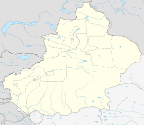 Hoboksar Location in Xinjiang | |
| Coordinates: 46°47′N 85°43′E / 46.783°N 85.717°ECoordinates: 46°47′N 85°43′E / 46.783°N 85.717°E | |
| Country | People's Republic of China |
| Region | Xinjiang |
| Prefecture | Tacheng |
| Township-level divisions |
2 towns 5 townships |
| County seat | Hoboksar Town (和布克赛尔镇) |
| Area | |
| • Total | 28,799 km2 (11,119 sq mi) |
| Population | |
| • Total | 50,000 |
| • Density | 1.7/km2 (4.5/sq mi) |
| Time zone | China Standard (UTC+8) |
| Postal code | 834400 |
| Area code(s) | 0901 |
| Hoboksar Mongol Autonomous County | |||||||||
| Chinese name | |||||||||
|---|---|---|---|---|---|---|---|---|---|
| Simplified Chinese | 和布克赛尔蒙古自治县 | ||||||||
| Traditional Chinese | 和布克賽爾蒙古自治縣 | ||||||||
| |||||||||
| Mongolian name | |||||||||
| Mongolian Cyrillic | Ховогсайр | ||||||||
| Mongolian script | ᠬᠣᠪᠣᠭᠰᠠᠶᠢᠷ ᠮᠣᠩᠭᠣᠯ ᠥᠪᠡᠷᠲᠡᠭᠡᠨ ᠵᠠᠰᠠᠬᠤ ᠰᠢᠶᠠᠨ | ||||||||
| |||||||||
| Uyghur name | |||||||||
| Uyghur |
قوبۇقسار | ||||||||
| |||||||||
| Kazakh name | |||||||||
| Kazakh |
قوبىقسارى موڭعۇل اۆتونوميالى اۋدانى Qobıqsarı Moñğul avtonomyalı awdanı Қобықсары Моңғұл автономйалы ауданы | ||||||||
Hoboksar Mongol Autonomous County is a county situated in the Xinjiang Uyghur Autonomous Region and is under the administrative jurisdiction of the Tacheng Prefecture. It has an area of 28,799 km² with a population of 50,000. The Postcode is 834400.
Geography
Hoboksar County is located south of the Tarbagatai-Saur mountain range, and its northern part, where most of the county's population lives, receives some water from streams (such as the Baiyang River) flowing from the snow-capped mountains. The southeastern part of the county is in Gurbantünggüt Desert.
Historically, the large Alan Nur and Manas Lake were located in the desert southwestern part of the county; they received water, at least intermittently, both from the streams flowing across the desert from the north and from the south (via the Manas River). Due to the increasing water diversion for irrigation and other human needs, as well as geological processes, the Alan Nur has fully dried out, and the Manas Lake is in a fairly precarious situation as well.[1]
The Irtysh–Karamay Canal, constructed around the turn of the 21st century, crosses the county's southeastern part; the canal's Fengcheng Reservoir is located on the county's border with Karamay City's Urho District.
A point situated some 30 miles ESE of Hoxtolgay Town is listed as the farthest point from the sea (at 46°16.8′N 86°40.2′E / 46.2800°N 86.6700°E) by the Guinness Book of World Records. It is roughly 2646 kilometres away from the Arctic Ocean and a similar distance from the Bay of Bengal and the Arabian Sea (see Continental Pole of Inaccessibility for other candidates).
The "record-setting" location of the county attracted the attention of advertisers for the Corona beer brand, who staged and documented a trip of a few residents of the village of Bulin (布林, 46°43′13″N 86°7′59″E / 46.72028°N 86.13306°E), in Hoboksar County's Chagankulei Township (Chinese: 查干库勒乡; pinyin: Chágànkùlei xiāng) to the sea coast in Hainan Island.[2]
Climate
| Climate data for Hoboksar County (1971−2000) | |||||||||||||
|---|---|---|---|---|---|---|---|---|---|---|---|---|---|
| Month | Jan | Feb | Mar | Apr | May | Jun | Jul | Aug | Sep | Oct | Nov | Dec | Year |
| Average high °C (°F) | −6.1 (21) |
−3.9 (25) |
2.0 (35.6) |
12.2 (54) |
19.0 (66.2) |
23.9 (75) |
25.6 (78.1) |
24.3 (75.7) |
18.5 (65.3) |
10.0 (50) |
0.8 (33.4) |
−4.4 (24.1) |
10.2 (50.3) |
| Average low °C (°F) | −16.8 (1.8) |
−15.1 (4.8) |
−9.2 (15.4) |
−0.3 (31.5) |
6.1 (43) |
11.4 (52.5) |
13.4 (56.1) |
11.5 (52.7) |
6.0 (42.8) |
−1.5 (29.3) |
−9.3 (15.3) |
−14.3 (6.3) |
−1.5 (29.3) |
| Average precipitation mm (inches) | 2.6 (0.102) |
2.3 (0.091) |
5.0 (0.197) |
8.0 (0.315) |
12.5 (0.492) |
25.1 (0.988) |
34.2 (1.346) |
21.0 (0.827) |
10.9 (0.429) |
5.3 (0.209) |
5.4 (0.213) |
4.1 (0.161) |
136.4 (5.37) |
| Average precipitation days (≥ 0.1 mm) | 4.1 | 3.8 | 5.6 | 5.3 | 7.2 | 9.4 | 11.0 | 8.6 | 5.7 | 4.1 | 5.1 | 5.3 | 75.2 |
| Average relative humidity (%) | 65 | 61 | 58 | 46 | 42 | 44 | 47 | 46 | 46 | 55 | 63 | 67 | 53.3 |
| Mean monthly sunshine hours | 181.5 | 198.0 | 253.1 | 273.6 | 297.7 | 291.4 | 300.2 | 299.1 | 271.3 | 226.3 | 170.6 | 155.1 | 2,917.9 |
| Percent possible sunshine | 66 | 69 | 69 | 68 | 64 | 62 | 63 | 68 | 72 | 67 | 61 | 58 | 65.6 |
| Source: China Meteorological Administration | |||||||||||||
Demographics
The Chinese Mongols that live in Bayingolin and Hoboksar come from varied origins. A majority are Torghuts, who speak the Oirat language. Chahar Mongols who immigrated from Inner Mongolia also live in Hoboksar and Bayingolin, and there are also Uriankhai Mongols, who are considered Mongols in China but Tuvans to some outside observers. A fair number of Daur people and Dongxiang people live in Hoboksar especially, and they speak Mongolic languages.[3]
Culture
Hoboksar is traditionally considered the place of origin of the Epic of Jangar. The Jangar Culture and Art Palace (江格尔文化艺术宫) was opened in the county in 2014.[4][5]
Transportation
China National Highway 217 and the new Kuytun–Beitun Railway both cross Hoboksar county along the same north-south corridor. There is daily passenger service at the Hoxtolgay station.
See also
References
- ↑ Yao, Yonghui; Li, Huiguo (2010), "Tectonic geomorphological characteristics for evolution of the Manas Lake", JOURNAL OF ARID LAND, 2 (3): 167–173
- ↑ Daniel Gilroy, Corona Extra: A Journey From ‘The Pole Of naccessibility’. Here's the campaign's web site: http://www.coronaextra.eu/china/#/
- ↑ Benson, Linda K.; Svanberg, Ingvar (1998). China's Last Nomads: The History and Culture of China's Kazaks. M.E. Sharpe. p. 25.
- ↑ Jangar Palace Opens in Xinjiang’s Hoboksar
- ↑ 世界最大的江格尔文化艺术宫建成投用
External links
- County government - official site (Chinese)
| Regions |  | ||||||||||||||
|---|---|---|---|---|---|---|---|---|---|---|---|---|---|---|---|
| Prefectures and counties |
| ||||||||||||||
Ethnic minority autonomous areas: Dong · Hui · Korean · Manchu · Miao · Mongol · Tibetan · Tujia · Uyghur · Yao · Yi · Zhuang · Other | |||||||||||||||