Huangnan Tibetan Autonomous Prefecture
| Huangnan Prefecture 黃南州 · རྨ་ལྷོ་ཁུལ། | |
|---|---|
| Autonomous prefectures | |
黄南藏族自治州 · རྨ་ལྷོ་བོད་རིགས་རང་སྐྱོང་ཁུལ་ | |
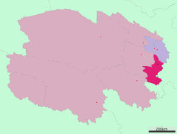 Location of Huangnan Prefecture in Qinghai | |
| Country | China |
| Province | Qinghai |
| Prefecture seat | Tongren County |
| Time zone | China Standard (UTC+8) |
Huangnan Tibetan Autonomous Prefecture (simplified Chinese: 黄南藏族自治州; traditional Chinese: 黃南藏族自治州; pinyin: Huángnán Zàngzú Zìzhìzhōu; Tibetan: རྨ་ལྷོ་བོད་རིགས་རང་སྐྱོང་ཁུལ་, Wylie: rma lho bod rigs rang skyong khul ) is an autonomous prefecture of eastern Qinghai, China, bordering Gansu to the east. The prefecture has area of 17,921 km2 (6,919 sq mi) and its seat is in Tongren County.
Demographics
According to the 2000 census, Huangnan has 214,642 inhabitants with a population density of 11.98 inhabitants/km² (31.03 inhabitants/sq. mi.).
Ethnic groups in Huangnan, 2000 census
| Nationality | Population | Percentage |
|---|---|---|
| Tibetan | 142,360 | 66.32% |
| Mongol | 29,071 | 13.54% |
| Hui | 16,411 | 7.65% |
| Han | 16,194 | 7.54% |
| Tu/Monguor | 8,445 | 3.93% |
| Salar | 1,530 | 0.71% |
| Others | 631 | 0.31% |
Climate
| Climate data for Tongren County(1981-2010) | |||||||||||||
|---|---|---|---|---|---|---|---|---|---|---|---|---|---|
| Month | Jan | Feb | Mar | Apr | May | Jun | Jul | Aug | Sep | Oct | Nov | Dec | Year |
| Record high °C (°F) | 15.1 (59.2) |
21.6 (70.9) |
27.0 (80.6) |
32.7 (90.9) |
30.9 (87.6) |
31.3 (88.3) |
35.0 (95) |
34.2 (93.6) |
32.5 (90.5) |
23.4 (74.1) |
19.8 (67.6) |
13.9 (57) |
35 (95) |
| Average high °C (°F) | 1.3 (34.3) |
4.8 (40.6) |
10.1 (50.2) |
15.7 (60.3) |
18.9 (66) |
21.3 (70.3) |
23.5 (74.3) |
23.4 (74.1) |
18.7 (65.7) |
13.6 (56.5) |
8.1 (46.6) |
2.7 (36.9) |
13.51 (56.32) |
| Daily mean °C (°F) | −6.6 (20.1) |
−3.2 (26.2) |
2.0 (35.6) |
7.8 (46) |
11.9 (53.4) |
14.7 (58.5) |
16.7 (62.1) |
16.1 (61) |
12.0 (53.6) |
6.3 (43.3) |
0.1 (32.2) |
−5.1 (22.8) |
6.06 (42.9) |
| Average low °C (°F) | −12.2 (10) |
−9.2 (15.4) |
−3.9 (25) |
1.4 (34.5) |
5.8 (42.4) |
9.1 (48.4) |
11.2 (52.2) |
10.5 (50.9) |
7.4 (45.3) |
1.4 (34.5) |
−5.4 (22.3) |
−10.6 (12.9) |
0.46 (32.82) |
| Record low °C (°F) | −22.6 (−8.7) |
−19.5 (−3.1) |
−15 (5) |
−9.3 (15.3) |
−3.7 (25.3) |
1.2 (34.2) |
4.3 (39.7) |
2.3 (36.1) |
−0.9 (30.4) |
−10.5 (13.1) |
−16.4 (2.5) |
−21.5 (−6.7) |
−22.6 (−8.7) |
| Average precipitation mm (inches) | 2.5 (0.098) |
3.9 (0.154) |
11.0 (0.433) |
22.6 (0.89) |
58.0 (2.283) |
64.5 (2.539) |
80.4 (3.165) |
70.8 (2.787) |
65.1 (2.563) |
25.9 (1.02) |
3.1 (0.122) |
0.8 (0.031) |
408.6 (16.085) |
| Source: China Meteorological Administration,[1] | |||||||||||||
Subdivisions
The prefecture is subdivided into 4 county-level divisions: 3 counties and 1 autonomous county:
| Map | # | Name | Simplified Chinese | Hanyu Pinyin | Tibetan | Wylie Tibetan Pinyin |
Population (2010 Census) |
Area (km²) | Density (/km²) |
|---|---|---|---|---|---|---|---|---|---|
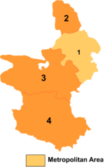 | |||||||||
| 1 | Tongren County | 同仁县 | Tóngrén Xiàn | Official: ཐུང་རིན་རྫོང་། (རེབ་གོང་རྫོང་། or རེ་སྐོང་རྫོང་།) |
thung rin rdzong Tungrin Zong |
92,601 | 3,465 | 26.72 | |
| 2 | Jainca County | 尖扎县 | Jiānzhā Xiàn | གཅན་ཚ་རྫོང་། | gcan tsha rdzong Jainca Zong |
55,325 | 1,712 | 32.31 | |
| 3 | Zêkog County | 泽库县 | Zékù Xiàn | རྩེ་ཁོག་རྫོང་། | rtse khog rdzong Zêkog Zong |
69,416 | 6,494 | 10.68 | |
| 4 | Henan Mongol Autonomous County | 河南蒙古族 自治县 |
Hénán Měnggǔzú Zìzhìxiàn |
རྨ་ལྷོ་སོག་རིགས་རང་སྐྱོང་རྫོང་། | rma lho sog rigs rang skyong rdzong Malho Sogrig Ranggyong Zong |
39,37 | 6,250 | 6.29 |
Rongwo Monastery
Huangnan is home to Rongwo Monastery, a Gelug monastery initially established in 1341 in Amdo on the Rongwo River.[2][3]
Further reading
- A. Gruschke: The Cultural Monuments of Tibet’s Outer Provinces: Amdo - Volume 1. The Qinghai Part of Amdo, White Lotus Press, Bangkok 2001. ISBN 974-480-049-6
- Tsering Shakya: The Dragon in the Land of Snows. A History of Modern Tibet Since 1947, London 1999, ISBN 0-14-019615-3
| Regions |  | ||||||||||||||
|---|---|---|---|---|---|---|---|---|---|---|---|---|---|---|---|
| Prefectures and counties |
| ||||||||||||||
Ethnic minority autonomous areas: Dong · Hui · Korean · Manchu · Miao · Mongol · Tibetan · Tujia · Uyghur · Yao · Yi · Zhuang · Other | |||||||||||||||
Coordinates: 35°31′36″N 102°00′50″E / 35.5267°N 102.014°E
References
- ↑ 中国地面国际交换站气候标准值月值数据集(1981-2010年). China Meteorological Administration. Retrieved January 1, 2011.
- ↑ http://www.baronet4tibet.com/sange_shong_info/rongwu.html
- ↑ Staff (6 February 2008). "Longwu Temple - garden of Tibetan Buddhism and Western Region". China Tour Guide. Retrieved 2010-02-04.