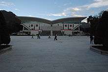
Lhasa

.png)
.svg.png)
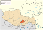
Lhasa is a city and administrative capital of the Tibet Autonomous Region of the People's Republic of China.[1] The main urban area of Lhasa is roughly equivalent to the administrative borders of Chengguan District, which is part of the wider Lhasa prefecture-level city, an area formerly administered as a prefecture.
Lhasa is the second most populous city on the Tibetan Plateau after Xining and, at an altitude of 3,490 metres (11,450 ft), Lhasa is one of the highest cities in the world. The city has been the religious and administrative capital of Tibet since the mid-17th century. It contains many culturally significant Tibetan Buddhist sites such as the Potala Palace, Jokhang Temple and Norbulingka Palaces.
Etymology
Lhasa literally means "place of the gods". Ancient Tibetan documents and inscriptions demonstrate that the place was called Rasa, which either meant "goats' place", or, as a contraction of rawe sa, a "place surrounded by a wall,"[2] or 'enclosure', suggesting that the site was originally a hunting preserve within the royal residence on Marpori Hill.[3] Lhasa is first recorded as the name, referring to the area's temple of Jowo, in a treaty drawn up between China and Tibet in 822 C.E.[4]
History
By the mid 7th century, Songtsän Gampo became the leader of the Tibetan Empire that had risen to power in the Brahmaputra River (locally known as the Yarlung Tsangpo River) Valley.[5] After conquering the kingdom of Zhangzhung in the west, he moved the capital from the Chingwa Taktsé Castle in Chongye County (pinyin: Qióngjié Xiàn), southwest of Yarlung, to Rasa (Lhasa) where in 637 he raised the first structures on the site of what is now the Potala Palace on Mount Marpori.[6] In CE 639 and 641, Songtsän Gampo, who by this time had conquered the whole Tibetan region, is said to have contracted two alliance marriages, firstly to a Princess Bhrikuti of Nepal,[7] and then, two years later, to Princess Wencheng of the Imperial Tang court. Bhrikuti is said to have converted him to Buddhism, which was also the faith attributed to his second wife Wencheng. In 641 he constructed the Jokhang (or Rasa Trülnang Tsulagkhang) and Ramoche Temples in Lhasa in order to house two Buddha statues, the Akshobhya Vajra (depicting the Buddha at the age of eight) and the Jowo Sakyamuni (depicting Buddha at the age of twelve), respectively brought to his court by the princesses.[8][9] Lhasa suffered extensive damage under the reign of Langdarma in the 9th century, when the sacred sites were destroyed and desecrated and the empire fragmented.[10]
A Tibetan tradition mentions that after Songtsän Gampo's death in 649 C.E., Chinese troops captured Lhasa and burnt the Red Palace.[11][12] Chinese and Tibetan scholars have noted that the event is mentioned neither in the Chinese annals nor in the Tibetan manuscripts of Dunhuang. Lǐ suggested that this tradition may derive from an interpolation.[13] Tsepon W. D. Shakabpa believes that "those histories reporting the arrival of Chinese troops are not correct."[12]
From the fall of the monarchy in the 9th century to the accession of the 5th Dalai Lama, the centre of political power in the Tibetan region was not situated in Lhasa. However, the importance of Lhasa as a religious site became increasingly significant as the centuries progressed.[14] It was known as the centre of Tibet where Padmasambhava magically pinned down the earth demoness and built the foundation of the Jokhang Temple over her heart.[15] Islam has been present since the 11th century in what is considered to have always been a monolithically Buddhist culture.[16] Two Tibetan Muslim communities have lived in Lhasa with distinct homes, food and clothing, language, education, trade and traditional herbal medicine.
By the 15th century, the city of Lhasa had risen to prominence following the founding of three large Gelugpa monasteries by Je Tsongkhapa and his disciples. The three monasteries are Ganden, Sera and Drepung which were built as part of the puritanical Buddhist revival in Tibet.[17] The scholarly achievements and political know-how of this Gelugpa Lineage eventually pushed Lhasa once more to centre stage.
The 5th Dalai Lama, Lobsang Gyatso (1617–1682), unified Tibet and moved the centre of his administration to Lhasa in 1642 with the help of Güshi Khan of the Khoshut. With Güshi Khan as a largely uninvolved overlord, the 5th Dalai Lama and his intimates established a civil administration which is referred to by historians as the Lhasa state. The core leadership of this government is also referred to as the Ganden Phodrang, and Lhasa thereafter became both the religious and political capital.[18] In 1645, the reconstruction of the Potala Palace began on Red Hill.[19] In 1648, the Potrang Karpo (White Palace) of the Potala was completed, and the Potala was used as a winter palace by the Dalai Lama from that time onwards.[20] The Potrang Marpo (Red Palace) was added between 1690 and 1694. The name Potala is derived from Mount Potalaka, the mythical abode of the Dalai Lama's divine prototype, the Bodhisattva Avalokiteśvara.[21] The Jokhang Temple was also greatly expanded around this time. Although some wooden carvings and lintels of the Jokhang Temple date to the 7th century, the oldest of Lhasa's extant buildings, such as within the Potala Palace, the Jokhang and some of the monasteries and properties in the Old Quarter date to this second flowering in Lhasa's history.
By the end of the 17th century, Lhasa's Barkhor area formed a bustling market for foreign goods. The Jesuit missionary, Ippolito Desideri reported in 1716 that the city had a cosmopolitan community of Mongol, Chinese, Muscovite, Armenian, Kashmiri, Nepalese and Northern Indian traders. Tibet was exporting musk, gold, medicinal plants, furs and yak tails to far-flung markets, in exchange for sugar, tea, saffron, Persian turquoise, European amber and Mediterranean coral.[22] The Qing dynasty army entered Lhasa in 1720, and the Qing government sent resident commissioners, called the Ambans, to Lhasa. In November 11 of 1750, the murder of the regent by the Ambans triggered a riot in the city that left more than a hundred people killed, including the Ambans. After suppressing the rebels, Qing Qianlong Emperor reorganized the Tibetan government and set up the governing council called Kashag in Lhasa in 1751.

In 1904 a British expedition force led by Francis Younghusband entered Lhasa and forced remaining low-level Tibetan officials to sign the Treaty of Lhasa after the fleeing of Dalai Lama. The treaty was subsequently repudiated and was succeeded by a 1906 Anglo-Chinese treaty. All Qing troops left Lhasa after the Xinhai Lhasa turmoil in 1912.
By the 20th century, Lhasa, long a beacon for both Tibetan and foreign Buddhists, had numerous ethnically and religiously distinct communities, among them Kashmiri Muslims, Ladakhi merchants, Sikh converts to Islam, and Chinese traders and officials. The Kashmiri Muslims (Khache) trace their arrival in Lhasa to the Muslim saint of Patna, Khair ud-Din, contemporary with the 5th Dalai Lama.[23] Chinese Muslims lived in a quarter to the south, and Newar merchants from Kathmandu to the north of the Barkhor market. Residents of the Lubu neighbourhood were descended from Chinese vegetable farmers who stayed over after accompanying an Amban from Sichuan in the mid-nineteenth century; some later intermarried with Tibetan women and spoke Tibetan as their first language.[24] The city's merchants catered to all kinds of tastes, importing even Australian butter and British whisky. In the 1940s, according to Heinrich Harrer:-
'There is nothing one cannot buy, or at least order. One even finds the Elizabeth Arden specialties, and there is a keen demand for them. . .You can order, too, sewing machines, radio sets and gramophones and hunt up Bing Crosby records.'[25]
Such markets and consumerism came to an abrupt end after the arrival of Chinese government troops and administrative cadres in 1950.[26] Food rations and poorly stocked government stores replaced the old markets, until the 1990s when commerce in international wares once more returned to Lhasa,[27] and arcades and malls with a cornucopia of goods sprang up.[28]
Of the 22 parks (lingkas) which surrounded the city of Lhasa, most of them over half a mile in length, where the people of Lhasa were accustomed to picnic, only three survive today: the Norbulingka, Dalai Lama's Summer Palace, constructed by the 7th Dalai Lama;[17] a small part of the Shugtri Lingka, and the Lukhang. Dormitory blocks, offices and army barracks are built over the rest.[29]

The Guāndì miào (關帝廟) or Gesar Lhakhang temple was erected by the Amban in 1792 atop Mount Bamare 3 kilometres (2 miles) south of the Potala to celebrate the defeat of an invading Gurkha army.[30]
The main gate to the city of Lhasa used to run through the large Pargo Kaling chorten and contained holy relics of the Buddha Mindukpa.[31]
Between 1987–1989 Lhasa experienced major demonstrations, led by monks and nuns, against the Chinese Government. After Deng Xiaoping's southern tour in 1992, Lhasa was mandated by the government to undergo economic liberalization. All government employees, their families and students were forbidden from practicing their religion, while monks and nuns were not allowed to enter government offices and the Tibet University campus. Subsequent to the introduction of the economic development policies, the influx of migrants has dramatically altered the city's ethnic mix in Lhasa.[32]
In 2000 the urbanised area covered 53 square kilometres (20 sq mi), with a population of around 170,000. Official statistics of the metropolitan area report that 70 percent are Tibetan, 34.3 are Han, and the remaining 2.7 Hui, though outside observers suspect that non-Tibetans account for some 50–70 percent. Among the Han immigrants, Lhasa is known as ‘Little Sichuan'.[32]
Geography
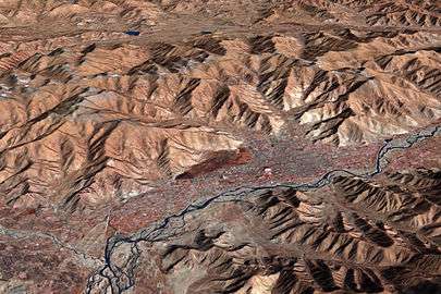

Lhasa has an elevation of about 3,600 m (11,800 ft)[33] and lies in the centre of the Tibetan Plateau with the surrounding mountains rising to 5,500 m (18,000 ft). The air only contains 68 percent of the oxygen compared to sea level.[34] The Lhasa River, also Kyi River or Kyi Chu, a tributary of the Yarlung Zangbo River (Brahmaputra River), runs through the southern part of the city. This river, known to local Tibetans as the "merry blue waves", flows through the snow-covered peaks and gullies of the Nyainqêntanglha mountains, extending 315 km (196 mi), and emptying into the Yarlung Zangbo River at Qüxü, forms an area of great scenic beauty. The marshlands, mostly uninhabited, are to the north.[35] Ingress and egress roads run east and west, while to the north, the road infrastructure is less developed.[35]
Chengguan District

Chengguan District is located on the middle reaches of the Lhasa River, a tributary of the Brahmaputra River, with land that rises to the north and south of the river. It is 28 kilometres (17 mi) from east to west and 31 kilometres (19 mi) from north to south. Chengguan District is bordered by Doilungdêqên District to the west, Dagzê County to the east and Lhünzhub County to the north. Gonggar County of Lhoka (Shannan) Prefecture lies to the south.[36]
Chengguan District has an elevation of 3,650 metres (11,980 ft) and covers 525 square kilometres (203 sq mi). The urban built-up area covers 60 square kilometres (23 sq mi). The average annual temperature of 8 °C (46 °F). Annual precipitation is about 500 millimetres (20 in), mostly falling between July and September.[36]
The term "Chengguan District" is the administrative term for the inner urban area or the urban centre within a prefecture, in this case the Prefectural-city of Lhasa. Chengguan District is at the same administrative level as a county.[37] Chengguan District of Lhasa was established on 23 April 1961. It currently has nine urban subdistricts and four rural townships.[38]
| Name | Tibetan | Chinese | Pinyin | Population (2010)[39] |
|---|---|---|---|---|
| Barkor Subdistrict (Barkhor) | བར་སྒོར་ | 八廓街道 | Bākuò jiēdào | 12,744 |
| Gyirai Subdistrict | སྐྱིད་རས་ | 吉日街道 | Jírì jiēdào | 21,022 |
| Jebumgang Subdistrict | རྗེ་འབུམ་སྒང་ | 吉崩岗街道 | Jí bēng gǎng jiēdào | 29,984 |
| Zhaxi Subdistrict | གྲ་བཞི་ | 扎细街道 | Zā xì jiēdào | 30,820 |
| Gündêling Subdistrict | ཀུན་བདེ་གླིང་ | 公德林街道 | Gōngdé lín jiēdào | 55,404 |
| Chomsigkang Subdistrict | ཁྲོམ་སྲིད་ཁང་ | 冲赛康街道 | Chōng sài kāng jiēdào | 79,363 |
| Karmakunsang Subdistrict | ཀརྨ་མ་ཀུན་བཟང་ | 嘎玛贡桑街道 | Gá mǎ gòng sāng jiēdào | 19,472 |
| Liangdao Subdistrict | ལེང་ཏའོ་ | 两岛街道 | Liǎng dǎo jiēdào | 14,055 |
| Jinzhu West Road Subdistrict | བཅིངས་འགྲོལ་ནུབ་ལམ་ | 金珠西路街道 | Jīn zhū xī lù jiēdào | established in 2013 |
| Caigungtang Township | ཚལ་གུང་ཐང་ | 蔡公堂乡 | Cài gōngtáng xiāng | 8,800 |
| Naqen Township | སྣ་ཆེན་ | 纳金乡 | Nà jīnxiāng | 29,575 |
| Nyangbran Township (Nyang bran) | ཉང་བྲན་ | 娘热乡 | Niáng rè xiāng | 26,354 |
| Togde Township | དོག་སྡེ་ | 夺底乡 | Duó de xiāng | 15,186 |
Climate


Due to its very high elevation, Lhasa has a cool semi-arid climate (Köppen: BSk) with frosty winters and mild summers, yet the valley location protects the city from intense cold or heat and strong winds. Monthly possible sunshine ranges from 53 percent in July to 84 percent in November, and the city receives nearly 3,000 hours of sunlight annually. It is thus sometimes called the "sunlit city" by Tibetans. The coldest month is January with an average temperature of −1.6 °C (29.1 °F) and the warmest month is June with a daily average of 16.0 °C (60.8 °F), though nights have generally been warmer in July.[40] The annual mean temperature is 7.98 °C (46.4 °F), with extreme temperatures ranging from −16.5 to 30.4 °C (2 to 87 °F).[41] Lhasa has an annual precipitation of 426 millimetres (16.8 in) with rain falling mainly in July, August and September. The driest month is January at 0.8 millimetres (0.03 in) and the wettest month is August, at 120.6 millimetres (4.75 in). The rainy season is widely regarded the "best" of the year as rains come mostly at night and Lhasa is still sunny during the daytime.
| Climate data for Lhasa (normals 1971−2000, extremes 1961−2000) | |||||||||||||
|---|---|---|---|---|---|---|---|---|---|---|---|---|---|
| Month | Jan | Feb | Mar | Apr | May | Jun | Jul | Aug | Sep | Oct | Nov | Dec | Year |
| Record high °C (°F) | 18.4 (65.1) |
20.6 (69.1) |
25.0 (77) |
25.0 (77) |
29.4 (84.9) |
30.4 (86.7) |
28.8 (83.8) |
27.2 (81) |
24.9 (76.8) |
23.0 (73.4) |
21.6 (70.9) |
17.8 (64) |
30.4 (86.7) |
| Average high °C (°F) | 7.2 (45) |
9.3 (48.7) |
12.7 (54.9) |
15.9 (60.6) |
19.9 (67.8) |
23.2 (73.8) |
22.6 (72.7) |
21.4 (70.5) |
19.9 (67.8) |
17.0 (62.6) |
12.1 (53.8) |
8.0 (46.4) |
15.8 (60.4) |
| Average low °C (°F) | −9 (16) |
−5.8 (21.6) |
−2.1 (28.2) |
1.5 (34.7) |
5.6 (42.1) |
9.8 (49.6) |
10.4 (50.7) |
9.7 (49.5) |
7.7 (45.9) |
2.0 (35.6) |
−4.2 (24.4) |
−8.2 (17.2) |
1.5 (34.6) |
| Record low °C (°F) | −16.5 (2.3) |
−14.5 (5.9) |
−10.2 (13.6) |
−8.1 (17.4) |
−2.7 (27.1) |
2.0 (35.6) |
4.5 (40.1) |
3.3 (37.9) |
0.3 (32.5) |
−6.7 (19.9) |
−10.5 (13.1) |
−15.8 (3.6) |
−16.5 (2.3) |
| Average precipitation mm (inches) | .8 (0.031) |
1.2 (0.047) |
2.9 (0.114) |
6.1 (0.24) |
27.7 (1.091) |
71.2 (2.803) |
116.6 (4.591) |
120.6 (4.748) |
68.3 (2.689) |
8.8 (0.346) |
1.3 (0.051) |
1.0 (0.039) |
426.5 (16.79) |
| Average precipitation days (≥ 0.1 mm) | .7 | 1.0 | 1.6 | 4.3 | 9.9 | 14.3 | 19.1 | 20.0 | 15.4 | 4.5 | .7 | .6 | 92.1 |
| Average relative humidity (%) | 28 | 26 | 27 | 37 | 44 | 51 | 62 | 66 | 64 | 49 | 38 | 34 | 43.8 |
| Mean monthly sunshine hours | 250.9 | 226.7 | 246.1 | 248.9 | 276.6 | 257.3 | 227.4 | 219.6 | 229.0 | 281.7 | 267.4 | 258.6 | 2,990.2 |
| Percent possible sunshine | 78 | 72 | 66 | 65 | 66 | 61 | 53 | 54 | 62 | 80 | 84 | 82 | 67 |
| Source: China Meteorological Administration,[40] all-time extreme temperature[41] | |||||||||||||
Demographics

Demographics in the past
The 11th edition of Encyclopædia Britannica published between 1910–1911 noted the total population of Lhasa, including the lamas in the city and vicinity was about 30,000;[42] a census in 1854 made the figure 42,000, but it is known to have greatly decreased since. Britannica noted that within Lhasa, there were about a total of 1,500 resident Tibetan laymen and about 5,500 Tibetan women.[42] The permanent population also included Chinese families (about 2,000).[42] The city's residents included traders from Nepal and Ladak (about 800), and a few from Bhutan, Mongolia and other places.[42] The Britannica noted with interest that the Chinese had a crowded burial-ground at Lhasa, tended carefully after their manner and that the Nepalese supplied mechanics and metal-workers at that time.[42]
In the first half of the 20th century, several Western explorers made celebrated journeys to the city, including William Montgomery McGovern, Francis Younghusband, Alexandra David-Néel and Heinrich Harrer. Lhasa was the centre of Tibetan Buddhism as nearly half of its population were monks,[43] Though this figure may include monks from surrounding monasteries who travelled to Lhasa for various celebrations and were not ordinarily resident there.
The majority of the pre-1950 Chinese population of Lhasa were merchants and officials. In the Lubu section of Lhasa, the inhabitants were descendants of Chinese vegetable farmers, some of whom married Tibetan wives. They came to Lhasa in the 1840s–1860s after a Chinese official was appointed to the position of Amban.[44]
According to one writer, the population of the city was about 10,000, with some 10,000 monks at Drepung and Sera monasteries in 1959[45] Hugh Richardson, on the other hand, puts the population of Lhasa in 1952, at "some 25,000–30,000—about 45,000–50,000 if the population of the great monasteries on its outskirts be included."[46]
Contemporary demographics
The total population of Lhasa Prefecture-level City is 521,500 (including known migrant population but excluding military garrisons). Of this, 257,400 are in the urban area (including a migrant population of 100,700), while 264,100 are outside.[47] Nearly half of Lhasa Prefecture-level City's population lives in Chengguan District, which is the administrative division that contains the urban area of Lhasa (i.e. the actual city).
The urban area is populated by ethnic Tibetans, Han, Hui and other ethnic groups.[36] The 2000 official census gave a total population of 223,001, of which 171,719 lived in the areas administered by city street offices and city neighborhood committees. 133,603 had urban registrations and 86,395 had rural registrations, based on their place of origin.[48] The census was taken in November, when many of the ethnic Han workers in seasonal industries such as construction would have been away from Tibet, and does not count the military.[48] A 2011 book estimated that up to two-thirds of the city's residents are non-Tibetan, although the government states that Chengguan District as a whole is still 63% ethnic Tibetan.[49] As of 2014 half of Tibet's Han population resided in Chengguan District of Lhasa, where bi-lingual or purely Chinese teaching was common in the schools.[50]
Economy
_Dieter_Schuh.JPG)

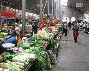
Competitive industry together with feature economy play key roles in the development of Lhasa. With the view to maintaining a balance between population growth and the environment, tourism and service industries are emphasised as growth engines for the future. Many of Lhasa's rural residents practice traditional agriculture and animal husbandry. Lhasa is also the traditional hub of the Tibetan trading network. For many years, chemical and car making plants operated in the area and this resulted in significant pollution, a factor which has changed in recent years. Copper, lead and zinc are mined nearby and there is ongoing experimentation regarding new methods of mineral mining and geothermal heat extraction.
Agriculture and animal husbandry in Lhasa are considered to be of a high standard. People mainly plant highland barley and winter wheat. The resources of water conservancy, geothermal heating, solar energy and various mines are abundant. There is widespread electricity together with the use of both machinery and traditional methods in the production of such things as textiles, leathers, plastics, matches and embroidery. The production of national handicrafts has made great progress.
_2007_Dieter_Schuh.JPG)
With the growth of tourism and service sectors, the sunset industries which cause serious pollution are expected to fade in the hope of building a healthy ecological system. Environmental problems such as soil erosion, acidification, and loss of vegetation are being addressed. The tourism industry now brings significant business to the region, building on the attractiveness of the Potala Palace, the Jokang, the Norbulingka Summer Palace and surrounding large monasteries as well the spectacular Himalayan landscape together with the many wild plants and animals native to the high altitudes of Central Asia. Tourism to Tibet dropped sharply following the crackdown on protests in 2008, but as early as 2009, the industry was recovering.[51] Chinese authorities plan an ambitious growth of tourism in the region aiming at 10 million visitors by 2020; these visitors are expected to be domestic. With renovation around historic sites, such as the Potala Palace, UNESCO has expressed "concerns about the deterioration of Lhasa's traditional cityscape."[52]

Lhasa contains several hotels. Lhasa Hotel is a 4-star hotel located northeast of Norbulingka in the western suburbs of the city. Completed in September 1985, it is the flagship of CITS's installations in Tibet. It accommodates about 1000 guests and visitors to Lhasa. There are over 450 rooms (suites) in the hotel, and all are equipped with air conditioning, mini-bar and other basic facilities. Some of the rooms are decorated in traditional Tibetan style. The hotel was operated by Holiday Inn from 1986 to 1997[53] and is the subject of a book, The Hotel on the Roof of the World. Another hotel of note is the historical Banak Shöl Hotel, located at 8 Beijing Road in the city.[54] It is known for its distinctive wooden verandas. The Nam-tso Restaurant is located in the vicinity of the hotel and is frequented especially by Chinese tourists visiting Lhasa.
Lhasa contains several businesses of note. Lhasa Carpet Factory, a factory south of Yanhe Dong Lu near the Tibet University, produces traditional Tibetan rugs that are exported worldwide. It is a modern factory, the largest manufacturer of rugs throughout Tibet, employing some 300 workers. Traditionally Tibetan women were the weavers, and men the spinners, but both work on the rugs today.
The Lhasa Brewery Company was established in 1988 on the northern outskirts of Lhasa, south of Sera Monastery and is the highest commercial brewery in the world at 11,975 feet (3,650 m) and accounts for 85 percent of contemporary beer production in Tibet.[55] The brewery, consisting of five-story buildings, cost an estimated US$20–25 million, and by 1994, production had reached 30,000 bottles per day, employing some 200 workers by this time.[56] Since 2000, the Carlsberg group has increased its stronghold in the Chinese market and has become increasingly influential in the country with investment and expertise. Carlsberg invested in the Lhasa Brewery in recent years and has drastically improved the brewing facility and working conditions, renovating and expanding the building to what now covers 62,240 square metres (15.3 acres).[57][58]
Architecture and cityscape
Lhasa has many sites of historic interest, including the Potala Palace, Jokhang Temple, Sera Monastery and Norbulingka. The Potala Palace, Jokhang Temple and the Norbulingka are UNESCO world heritage sites.[59] However, many important sites were damaged or destroyed mostly, but not solely, during China's Cultural Revolution of the 1960s.[60][61][62] Many have been restored since the 1980s.
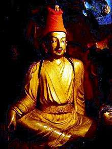
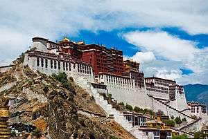
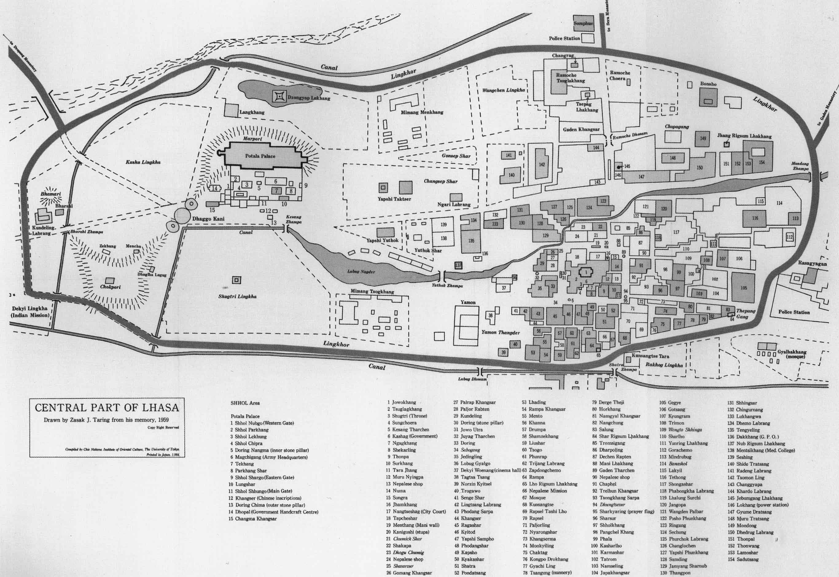
The Potala Palace, named after Mount Potala, the abode of Chenresig or Avalokitesvara,[63] was the chief residence of the Dalai Lama. After the 14th Dalai Lama fled to India during the 1959 Tibetan uprising, the government converted the palace into a museum. The site was used as a meditation retreat by King Songtsen Gampo, who in 637 built the first palace there in order to greet his bride Princess Wen Cheng of the Tang dynasty of China. Lozang Gyatso, the Great Fifth Dalai Lama, started the construction of the Potala Palace in 1645[19] after one of his spiritual advisers, Konchog Chophel (d. 1646), pointed out that the site was ideal as a seat of government, situated as it is between Drepung and Sera monasteries and the old city of Lhasa.[20] The palace underwent restoration works between 1989 and 1994, costing RMB55 million (US$6.875 million) and was inscribed to the UNESCO World Heritage List in 1994.

The Lhasa Zhol Pillar, below the Potala, dates as far back as circa 764 CE.[64] and is inscribed with what may be the oldest known example of Tibetan writing.[65] The pillar contains dedications to a famous Tibetan general and gives an account of his services to the king including campaigns against China which culminated in the brief capture of the Chinese capital Chang'an (modern Xian) in 763 CE[66] during which the Tibetans temporarily installed as Emperor a relative of Princess Jincheng Gongzhu (Kim-sheng Kong co), the Chinese wife of Trisong Detsen's father, Me Agtsom.[67][68]
.jpg)
Chokpori, meaning 'Iron Mountain', is a sacred hill, located south of the Potala. It is considered to be one of the four holy mountains of central Tibet and along with two other hills in Lhasa represent the "Three Protectors of Tibet.", Chokpori (Vajrapani), Pongwari (Manjushri), and Marpori (Chenresig or Avalokiteshvara).[69] It was the site of the most famous medical school Tibet, known as the Mentsikhang, which was founded in 1413. It was conceived of by Lobsang Gyatso, the "Great" 5th Dalai Lama, and completed by the Regent Sangye Gyatso (Sangs-rgyas rgya-mtsho)[70] shortly before 1697.
Lingkhor is a sacred path, most commonly used to name the outer pilgrim road in Lhasa matching its inner twin, Barkhor. The Lingkhor in Lhasa was 8 kilometres (5.0 mi) long enclosing Old Lhasa, the Potala and Chokpori hill. In former times it was crowded with men and women covering its length in prostrations, beggars and pilgrims approaching the city for the first time. The road passed through willow-shaded parks where the Tibetans used to picnic in summer and watch open air operas on festival days. New Lhasa has obliterated most of Lingkhor, but one stretch still remains west of Chokpori.

The Norbulingka palace and surrounding park is situated in the west side of Lhasa, a short distance to the southwest of Potala Palace and with an area of around 36 hectares (89 acres), it is considered to be the largest man made garden in Tibet.[71][72] It was built from 1755.[73] and served as the traditional summer residence of the successive Dalai Lamas until the 14th's self-imposed exile. Norbulingka was declared a ‘National Important Cultural Relic Unit”, in 1988 by the State council. In 2001, the Central Committee of the Chinese Government in its 4th Tibet Session resolved to restore the complex to its original glory. The Sho Dun Festival (popularly known as the "yogurt festival") is an annual festival held at Norbulingka during the seventh Tibetan month in the first seven days of the Full Moon period, which corresponds to dates in July/August according to the Gregorian calendar.
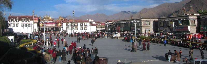
The Barkhor is an area of narrow streets and a public square in the old part of the city located around Jokhang Temple and was the most popular devotional circumabulation for pilgrims and locals. The walk was about one kilometre (0.6 miles) long and encircled the entire Jokhang, the former seat of the State Oracle in Lhasa called the Muru Nyingba Monastery, and a number of nobles' houses including Tromzikhang and Jamkhang. There were four large incense burners (sangkangs) in the four cardinal directions, with incense burning constantly, to please the gods protecting the Jokhang.[74] Most of the old streets and buildings have been demolished in recent times and replaced with wider streets and new buildings. Some buildings in the Barkhor were damaged in the 2008 unrest.[75]
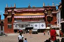
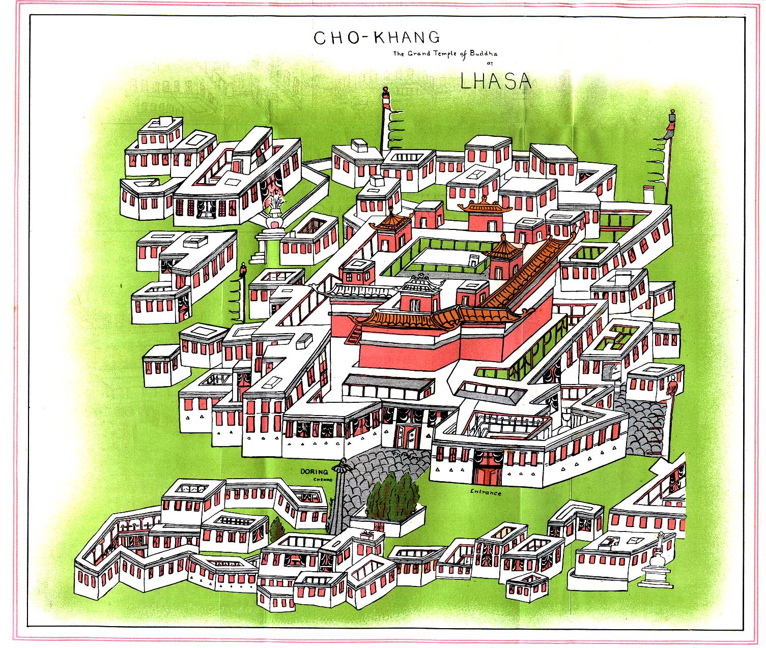
The Jokhang is located on Barkhor Square in the old town section of Lhasa. For most Tibetans it is the most sacred and important temple in Tibet. It is in some regards pan-sectarian, but is presently controlled by the Gelug school. Along with the Potala Palace, it is probably the most popular tourist attraction in Lhasa. It is part of the UNESCO World Heritage Site "Historic Ensemble of the Potala Palace," and a spiritual centre of Lhasa. This temple has remained a key center of Buddhist pilgrimage for centuries. The circumabulation route is known as the "kora" in Tibetan and is marked by four large stone incense burners placed at the corners of the temple complex. The Jokhang temple is a four-story construction, with roofs covered with gilded bronze tiles. The architectural style is based on the Indian vihara design, and was later extended resulting in a blend of Nepalese and Tang dynasty styles. It possesses the statues of Chenresig, Padmasambhava and King Songtsan Gambo and his two foreign brides, Princess Wen Cheng (niece of Emperor Taizong of Tang) and Princess Bhrikuti of Nepal and other important items.
Ramoche Temple is considered the most important temple in Lhasa after the Jokhang Temple. Situated in the northwest of the city, it is east of the Potala and north of the Jokhang,[76] covering a total area of 4,000 square meters (almost one acre). The temple was gutted and partially destroyed in the 1960s and its famous bronze statue disappeared. In 1983 the lower part of it was said to have been found in a Lhasa rubbish tip, and the upper half in Beijing. They have now been joined and the statue is housed in the Ramoche Temple, which was partially restored in 1986,[76] and still showed severe damage in 1993. Following the major restoration of 1986, the main building in the temple now has three stories.


The Tibet Museum in Lhasa is the official museum of the Tibet Autonomous Region and was inaugurated on October 5, 1999. It is the first large, modern museum in the Tibet Autonomous Region and has a permanent collection of around 1000 artefacts, from examples of Tibetan art to architectural design throughout history such as Tibetan doors and construction beams.[77][78] It is located in an L-shaped building west of the Potala Palace on the corner of Norbulingkha Road. The museum is organized into three main sections: a main exhibition hall, a folk cultural garden and administrative offices.[77]
The Monument to the Peaceful Liberation of Tibet was unveiled in the Potala Square in May 2002 to celebrate the 51st anniversary of the Seventeen Point Agreement for the Peaceful Liberation of Tibet, and the work in the development of the autonomous region since then. The 37-metre-high concrete monument is shaped as an abstract Mount Everest and its name is engraved with the calligraphy of former president Jiang Zemin, while an inscription describes the socioeconomic development experienced in Tibet in the past fifty years.[79]

Culture
Music and dance
There are some night spots that feature cabaret acts in which performers sing in Chinese, Tibetan, English, and Nepali, and dancers wear traditional Tibetan costume with long flowing cloth extending from their arms. There are a number of small bars that feature live music, although they typically have limited drink menus and cater mostly to foreign tourists.
Education
Tibet University
Tibet University (Tibetan: བོད་ལྗོངས་སློབ་གྲྭ་ཆེན་མོ་) is the main university of the Tibet Autonomous Region. Its campus is in Lhasa, east of the city-centre. A forerunner was created in 1952 and the university was officially established in 1985, funded by the Chinese government. About 8000 students are enrolled at the university.
Transport


Rail
Lhasa has been served by rail since 2006, when the Qinghai–Tibet Railway opened for passenger operations. Reaching an elevation of 5,072 meters above sea level, the Qinghai-Tibet railway is the world's highest railroad by elevation. It connects Lhasa with Xining, the capital of Qinghai Province, some 2,000 km (1,200 mi) away, and ultimately links Lhasa with other major cities with China's extensive railway network.[80] Five trains arrive at and depart from Lhasa railway station each day. Train number Z21 takes 40 hours and 53 minutes from Beijing West, arriving in Lhasa at 13:03 every day. Train Z22 from Lhasa to Beijing West departs at 15:30 and arrives in Beijing at 08:20 on the third day, taking 40 hours, 50 minutes. Trains also arrive in Lhasa from Chengdu, Chongqing, Lanzhou, Xining, Guangzhou, Shanghai and other cities.[81] To counter the problem of altitude differences giving passengers altitude sickness, extra oxygen is pumped in through the ventilation system and available directly on each berth with close open control by a flap for convenience of passenger, and personal oxygen masks are available on request.[82] Lhasa is also connected to the second largest city in Tibet, Xigazê, by rail service, since 2014. A third railroad, the Sichuan-Tibet Railway, which links Lhasa with Nyingchi County and into the interior ultimately terminating in Chengdu, began construction in June 2015.[83]
For onward rail travel in South Asia, the closest major station in India is New Jalpaiguri, Siliguri in West Bengal. However, extension of the Indian railway system to Sikkim will make it easier for onward connections through the South Asian railway network. There are preliminary plans to link Lhasa by rail with Kathmandu.[84]
As per a Chinese Tibetan spokesperson, extension of this rail line to Kathmandu with tunneling under Mount Everest is expected to be completed by 2020.[85]
Air
Lhasa Gonggar Airport (IATA: LXA), built in 1965, is the aviation hub of Tibet. It is located south of the city proper. It takes around half an hour to get there by car via the Lhasa Airport Expressway; prior to the completion of the expressway in 2011, the trip to the airport took over an hour. As of 2014, there are daily flights serving major Chinese cities including Beijing, Chengdu, Guangzhou, and Shanghai, and there are also occasional scheduled services to Kathmandu in Nepal. Lhasa Airport is the hub of Tibet Airlines, which offers regional services to other destinations in Tibet such as Nyingchi Prefecture, Ngari Prefecture, Shigatse, and Qamdo.

Road
The Qinghai–Tibet Highway (part of G109) runs northeast toward Xining and eventually to Beijing and is the most-used road in Tibet. The Sichuan–Tibet Highway (part of G318) runs east towards Chengdu and eventually to Shanghai. G318 also runs west to Zhangmu on the Nepal border. The Xinjiang-Tibet Highway (G219) runs north from Lhasa to Yecheng, and then to Xinjiang. This road is rarely used due to the lack of amenities and petrol stations. A new 37.68 kilometres (23.41 mi), four-lane highway between Lhasa and the Gonggar Airport was built by the Transportation Department of Tibet at a cost of RMB 1.5 billion. This road is part of National Highway 318 and starts from the Lhasa Railway Station, passes through Caina Township in Qushui County, terminating between the north entrance of the Gala Mountain Tunnel and the south bridgehead of the Lhasa River Bridge, and en route goes over the first overpass of Lhasa at Liuwu Overpass.[86]
Maritime
The closest seaport is Kolkata, India. The Nathu La pass offers Chinese companies access to the port of Kolkata (Calcutta), situated about 1,100 km (680 mi) from Lhasa, for transshipments to and from Tibet.
See also
Footnotes
- ↑ "Illuminating China's Provinces, Municipalities and Autonomous Regions". China.org.cn. Retrieved 2014-05-17.
- ↑ Anne-Marie Blondeau and Yonten Gyatso, 'Lhasa, Legend and History,' in Françoise Pommaret-Imaeda (ed.)Lhasa in the seventeenth century: the capital of the Dalai Lamas, BRILL, 2003, pp.15–38, pp.21–22.
- ↑ John Powers, Introduction to Tibetan Buddhism, Snow Lion Publications, 2007, p.144.
- ↑ Anne-Marie Blondeau and Yonten Gyatso, 'Lhasa, Legend and History,' pp.21–22.
- ↑ Stein, R. A. Tibetan Civilization 1962. Revised English edition, 1972, Faber & Faber, London. Reprint, 1972. Stanford University Press, p. 62. ISBN 0-8047-0806-1 cloth; ISBN 0-8047-0901-7 pbk., p. 59.
- ↑ Dorje (1999), p. 201.
- ↑ Snellgrove, David. 1987. Indo-Tibetan Buddhism: Indian Buddhists and Their Tibetan Successors. 2 Vols. Shambhala, Boston, Vol. II, p. 416.
- ↑ Anne-Marie Blondeau, Yonten Gyatso, 'Lhasa, Legend and History,' in Françoise Pommaret(ed.) Lhasa in the seventeenth century: the capital of the Dalai Lamas, Brill Tibetan Studies Library, 3, Brill 2003, pp.15-38, pp15ff.
- ↑ Amund Sinding-Larsen, The Lhasa atlas: : traditional Tibetan architecture and townscape, Serindia Publications, Inc., 2001 p.14
- ↑ Dorje (1999), pp. 68–9.
- ↑ Bell, Charles (1924). &pg=PA28 Tibet Past and Present Check
|url=value (help). p. 28. Reprinted in 1992 by CUP Motilal Banarsidass, ISBN 81-208-1048-1. - 1 2 Shakabpa, W. D. (2010) [1976]. &pg=PA123 One hundred thousand moons, Volume 1 Check
|url=value (help). trans. by Derek F. Maher. BRILL. p. 123. ISBN 90-04-17788-4. - ↑ Li, Tiezheng (1956). The historical status of Tibet. King's Crown Press, Columbia University. p. 6.
- ↑ Bloudeau, Anne-Mari & Gyatso, Yonten. 'Lhasa, Legend and History' in Lhasa in the Seventeenth Century: The Capital of the Dalai Lamas, 2003, pp. 24-25.
- ↑ Bloudeau, Anne-Mari & Gyatso, Yonten. "Lhasa, Legend and History." In: Lhasa in the Seventeenth Century: The Capital of the Dalai Lamas. Françoise Pommaret-Imaeda, Françoise Pommaret 2003, p. 38. Brill, Netherlands. ISBN 978-90-04-12866-8.
- ↑ The Ornaments of Lhasa, Islam in Tibet, Produced by Gray Henry
- 1 2 Dorje (1999), p. 69.
- ↑ Berzin, Alexander (1996). "The History of the Early Period of Buddhism and Bon in Tibet". The Historical Interaction between the Buddhist and Islamic Cultures before the Mongol Empire. Study Buddhism. Retrieved 20 June 2016.
With Tibet conceived as a demoness lying on her back and locations for the temples carefully selected according to the rules of Chinese acupuncture applied to the body of the demoness, Songtsen-gampo hoped to neutralize any opposition to his rule from local malevolent spirits. Of the thirteen Buddhist temples, the major one was constructed eighty miles from the imperial capital, at the site that later became known as “Lhasa” (Lha-sa, The Place of the Gods). At the time, it was called "Rasa" (Ra-sa, The Place of the Goats). Western scholars speculate that the Emperor was persuaded to avoid building the temple at the capital so as not to offend the traditional gods.
- 1 2 Laird, Thomas. (2006). The Story of Tibet: Conversations with the Dalai Lama, pp. 175. Grove Press, New York. ISBN 978-0-8021-1827-1.
- 1 2 Karmay, Samten C. (2005). "The Great Fifth", p. 1. Downloaded as a pdf file on 16 December 2007 from:
- ↑ Stein, R. A. Tibetan Civilization (1962). Translated into English with minor revisions by the author. 1st English edition by Faber & Faber, London (1972). Reprint: Stanford University Press (1972), p. 84
- ↑ Emily T. Yeh,'Living Together in Lhasa: Ethnic Relations, Coercive Amity, and Subaltern Cosmopolitanism,' in Shail Mayaram (ed.) The other global city, Taylor & Francis US. 2009, pp.54-85, pp.58-7.
- ↑ John Bray, 'Trader, Middleman or Spy? The Dilemmas of a Kashmiri Muslim in Early Nineteenth-Century Tibet,' in Anna Akasoy, Charles Burnett, Ronit Yoeli-Tlalim (eds.)Islam and Tibet: Interactions Along the Musk Routes, Ashgate Publishing, Ltd., 2011, pp.313-338, p.315.
- ↑ Emily T. Yeh,'Living Together in Lhasa: Ethnic Relations, Coercive Amity, and Subaltern Cosmopolitanism,' pp.59-60.
- ↑ Heinrich Harrer, Seven Years in Tibet, Penguin 1997 p.140, cited in Peter Bishop, The myth of Shangri-La: Tibet, travel writing, and the western creation of sacred landscape, University of California Press, 1989 p.192.
- ↑ Robert Barnett, Lhasa: Streets with Memories, Columbia University Press, 2010 p.65
- ↑ Emily T. Yeh,'Living Together in Lhasa: Ethnic Relations, Coercive Amity, and Subaltern Cosmopolitanism,' p.58.
- ↑ Robert Barnett, Lhasa: Streets with Memories, p.104.
- ↑ Robert Barnett, Lhasa: Streets with Memories, Columbia University Press, 2010 p.67: "Today, except for the Dalai Lama's Summer Palace, a small part of the Shugtri Lingka (now renamed the People's Park), and the Lukhang, those parks have disappeared."
- ↑ Emily T. Yeh,'Living Together in Lhasa: Ethnic Relations, Coercive Amity, and Subaltern Cosmopolitanism,' p.60; The monument however does not commemorate the Tibetan epic hero, but the Chinese figure. See Lara Maconi, ‘Gesar de Pékin? Le sort du Roi Gesar de Gling, héros épique tibétain, en Chinese (post-) maoïste,’ in Judith Labarthe, Formes modernes de la poésie épique: nouvelles approches, Peter Lang, 2004 pp.371–419, p.373 n.7. Relying on H. Richardson, and R. A. Stein, Maconi says that this was erected by the Chinese general Fu Kang'an (福康安).
- ↑ Tung (1980), p.21 and caption to plate 17, p. 42.
- 1 2 Emily T. Yeh,'Living Together in Lhasa: Ethnic Relations, Coercive Amity, and Subaltern Cosmopolitanism,' p.70.
- ↑ National Geographic Atlas of China. (2008), p. 88. National Geographic, Washington D.C. ISBN 978-1-4262-0136-3.
- ↑ Dorje (1999), p. 68.
- 1 2 Barnett, Robert (2006). Lhasa: streets with memories. Columbia University Press. p. 42. ISBN 0-231-13680-3.
- 1 2 3 Chengguan District of Lhasa, Baidu Baike.
- ↑ Subramanya 2004, p. 486.
- ↑ "2013年统计用区划代码和城乡划分代码:城关区". stats.gov.cn. National Bureau of Statistics of the People's Republic of China. Retrieved 6 April 2015.
- ↑ shi, Guo wu yuan ren kou pu cha ban gong; council, Guo jia tong ji ju ren kou he jiu ye tong ji si bian=Tabulation on the 2010 population census of the people's republic of China by township / compiled by Population census office under the state; population, Department of; statistics, employment statistics national bureau of (2012). Zhongguo 2010 nian ren kou pu cha fen xiang, zhen, jie dao zi liao (Di 1 ban. ed.). Beijing Shi: Zhongguo tong ji chu ban she. ISBN 978-7-5037-6660-2.
- 1 2 中国地面国际交换站气候标准值月值数据集(1971-2000年) (in Chinese). China Meteorological Administration. Retrieved 2010-05-04.
- 1 2 "Extreme Temperatures Around the World". Retrieved 2013-02-21.
- 1 2 3 4 5 LHASA. Encyclopædia Britannica, 11th Edition
- ↑ Barnett, Robert (2013). Lhasa: Streets with Memories. Columbia University Press. ISBN 9780231510110.
population of Lhasa in 1904 was estimated by the British at 30,000 people, of whom 20,000 were said to be monks [...] in 1936 Spencer Chapman estimated the population at 50,000 to 60,000, consisting of 20,000 residents and 30,000 to 40,000 monks
- ↑ Mayaram, Shail (2009). The other global city. Taylor & Francis US. p. 60. ISBN 0-415-99194-3. Retrieved 2010-06-28.
- ↑ Dowman (1988), p. 39.
- ↑ Richardson (1984), p. 7.
- ↑ People's Government of Lhasa Official Website - "Administrative divisions" Archived August 13, 2006, at the Wayback Machine.
- 1 2 Yeh & Henderson 2008, pp. 21–25.
- ↑ Johnson 2011, p. 81.
- ↑ Leibold & Chen 2014, p. 117.
- ↑ Xinhua, "Tibet tourism warms as spring comes", 2009-02-13.
- ↑ Miles, Paul (8 April 2005). "Tourism drive 'is destroying Tibet'". London: Telegraph. Retrieved 20 May 2009.
- ↑ "Lhasa Hotel in Lhasa, China - Lonely Planet". Hotels.lonelyplanet.com. Retrieved 2013-03-26.
- ↑ Lonely Planet
- ↑ "Lhasa beer from Tibet makes US debut". Tibet Sun. August 12, 2009. Retrieved September 27, 2009.
- ↑ Gluckman, Ron (1994). Brewing at the Top of the World. Asia, Inc.
- ↑ "Carlsberg China". Carlsberg Group. Retrieved September 27, 2009.
- ↑ "The Beer". Lhasa Beer USA. Archived from the original on July 6, 2009. Retrieved September 27, 2009.
- ↑ "Historic Ensemble of the Potala Palace, Lhasa". unesco. Retrieved 2008-02-10. In the surrounding prefecture of Lhasa are Sera Monastery and its many hermitages, many of which overlook Lhasa from the northern hill valleys and Drepung Monastery, amongst many others of historical importance.
- ↑ Bradley Mayhew and Michael Kohn. Tibet. 6th Edition (2005), pp. 36–37. Lonely Planet. ISBN 1-74059-523-8
- ↑ Keith Dowman. The Power-Places of Central Tibet: The Pilgrim's Guide, (1988) pp. 8–13. Routledge & Kegan Paul, Ltd., London and New York. ISBN 0-7102-1370-0.
- ↑ Laird, Thomas. (2006). The Story of Tibet: Conversations with the Dalai Lama, pp. 345–351.Grove Press, New York. ISBN 978-0-8021-1827-1.
- ↑ Stein, R. A. Tibetan Civilization (1962). Translated into English with minor revisions by the author. 1st English edition by Faber & Faber, London (1972). Reprint: Stanford University Press (1972), p. 84
- ↑ Richardson (1985), p. 2.
- ↑ Coulmas, Florian (1999). "Tibetan writing". Blackwell Reference Online. Retrieved 2009-10-20.
- ↑ Snellgrove and Richardson (1995), p. 91.
- ↑ Richardson (1984), p. 30.
- ↑ Beckwith (1987), p. 148.
- ↑ Stein, R. A. (1972). Tibetan Civilization, p. 228. Translated by J. E. Stapleton Driver. Stanford University Press, Stanford, California. ISBN 0-8047-0806-1 (cloth); ISBN 0-8047-0901-7 (paper).
- ↑ Dowman, Keith. (1988). The Power-Places of Central Tibet: The Pilgrim's Guide, p. 49. Routledge & Kegan Paul Ltd., London. ISBN 0-7102-1370-0.
- ↑ "Norbulingka Palace". Tibet Tours. Retrieved 2010-05-18.
- ↑ "Norbulingka". Cultural China. Retrieved 2010-05-23.
- ↑ Tibet (1986), p.71
- ↑ Dowman, Keith (1998). The Power-Places of Central Tibet: The Pilgrim's Guide, pp. 40–41. Routledge & Kegan Paul, London and New York. ISBN 0-7102-1370-0.
- ↑ Philip, Bruno (19 March 2008). "Trashing the Beijing road". The Economist. Retrieved 2010-02-03.
- 1 2 Dowman, Keith. 1988. The Power-Places of Central Tibet: The Pilgrim's Guide, p. 59. Routledge & Kegan Paul. London. ISBN 0-7102-1370-0 (ppk).
- 1 2 "The Tibet Museum". China Tibet Information Center. Retrieved May 18, 2010.
- ↑ "Tibet Museum". China Museums. Retrieved May 18, 2010.
- ↑ "Monument to Tibet Peaceful Liberation Unveiled". China Tibet Tourism Bureau. Retrieved October 26, 2010.
- ↑ World's highest railway Qinghai-Tibet Railway to be extended to Xigaze from Lhasa - Apple Travel
- ↑ "How to Get to Lhasa" ChinaTour.net Accessed 2015-3-23
- ↑ Cody, Edward (2006-07-04). "Train 27, Now Arriving Tibet, in a 'Great Leap West'". The Washington Post. Retrieved 2010-05-07.
- ↑ "拉林铁路预计2014年9月份动工 全线435.39千米". China Tibet News. January 15, 2014.
- ↑ "Extend Tibet railway line to Kathmandu, Nepal tells China". The Indian Express. October 12, 2009.
- ↑ China may build rail tunnel under Mount Everest, state media reports
- ↑ "New highway linking Lhasa to Gonggar Airport to be built".
Sources
- "Chengguan District of Lhasa". Baidu Baike. Baidu. Retrieved 2015-02-17.
- Johnson, Tim (2011). Tragedy in Crimson: How the Dalai Lama Conquered the World But Lost the Battle with China. Nation Books. ISBN 978-1-56858-649-6. Retrieved 2015-02-17.
- Leibold, James; Chen, Yangbin (2014-03-04). Minority Education in China: Balancing Unity and Diversity in an Era of Critical Pluralism. Hong Kong University Press. ISBN 978-988-8208-13-5. Retrieved 2015-02-17.
- Subramanya, N. (2004). Human Rights and Refugees. APH Publishing. ISBN 978-81-7648-683-5. Retrieved 2015-02-17.
- Yeh, Emily T.; Henderson, Mark (December 2008). "Interpreting Urbanization in Tibet". Journal of the International Association of Tibetan Studies. 4. Retrieved 2015-02-12.
References
- Das, Sarat Chandra. 1902. Lhasa and Central Tibet. Reprint: Mehra Offset Press, Delhi. 1988. ISBN 81-86230-17-3
- Dorje, Gyurme. 1999. Footprint Tibet Handbook. 2nd Edition. Bath, England. ISBN 1-900949-33-4. Also published in Chicago, U.S.A. ISBN 0-8442-2190-2.
- Dowman, Keith. 1988. The Power-Places of Central Tibet: The Pilgrim's Guide, p. 59. Routledge & Kegan Paul. London. ISBN 0-7102-1370-0 (ppk).
- Forbes, Andrew ; Henley, David (2011). China's Ancient Tea Horse Road. Chiang Mai: Cognoscenti Books. ASIN: B005DQV7Q2
- Jianqiang, Liu (2006). chinadialogue - Preserving Lhasa's history (part one).
- Miles, Paul. (April 9, 2005). "Tourism drive 'is destroying Tibet' Unesco fears for Lhasa's World Heritage sites as the Chinese try to pull in 10 million visitors a year by 2020". Daily Telegraph (London), p. 4.
- Pelliot, Paul. (1961) Histoire ancienne du Tibet. Libraire d'Amérique et d'orient. Paris.
- Richardson, Hugh E (1984). Tibet and its History. Second Edition, Revised and Updated. Shambhala Publications, Boston. ISBN 0-87773-376-7.
- Richardson, Hugh E (1997). Lhasa. In Encyclopedia Americana international edition, (Vol. 17, pp. 281–282). Danbury, CT: Grolier Inc.
- Stein, R. A. (1972). Tibetan Civilization, p. 38. Reprint 1972. Stanford University Press. ISBN 0-8047-0806-1 (cloth); ISBN 0-8047-0901-7 (paper).
- Tuladhar, Kamal Ratna (2011). Caravan to Lhasa: A Merchant of Kathmandu in Traditional Tibet. Kathmandu: Lijala & Tisa. ISBN 99946-58-91-3.
- Tung, Rosemary Jones. 1980. A Portrait of Lost Tibet. Thomas and Hudson, London. ISBN 0-500-54068-3.
- Vitali, Roberto. 1990. Early Temples of Central Tibet. Serindia Publications. London. ISBN 0-906026-25-3.
- (2006). Lhasa – Lhasa Intro
- von Schroeder, Ulrich. (1981). Indo-Tibetan Bronzes. (608 pages, 1244 illustrations). Hong Kong: Visual Dharma Publications Ltd. ISBN 962-7049-01-8
- von Schroeder, Ulrich. (2001). Buddhist Sculptures in Tibet. Vol. One: India & Nepal; Vol. Two: Tibet & China. (Volume One: 655 pages with 766 illustrations; Volume Two: 675 pages with 987 illustrations). Hong Kong: Visual Dharma Publications, Ltd.). ISBN 962-7049-07-7
- von Schroeder, Ulrich. 2008. 108 Buddhist Statues in Tibet. (212 p., 112 colour illustrations) (DVD with 527 digital photographs). Chicago: Serindia Publications. ISBN 962-7049-08-5
Further reading
- Desideri (1932). An Account of Tibet: The Travels of Ippolito Desideri 1712-1727. Ippolito Desideri. Edited by Filippo De Filippi. Introduction by C. Wessels. Reproduced by Rupa & Co, New Delhi. 2005
- Le Sueur, Alec (2013). The Hotel on the Roof of the World – Five Years in Tibet. Chichester: Summersdale. ISBN 978-1-84024-199-0. Oakland: RDR Books. ISBN 978-1-57143-101-1
External links
| Wikimedia Commons has media related to Lhasa. |
| Wikimedia Commons has media related to Chengguan District, Lhasa. |
- People's Government of Lhasa Official Website (Chinese)
- Lhasa @ China Tibet Information Center
- Lhasa Nights art exhibition
- Grand temple of Buddha at Lhasa in 1902, Perry-Castañeda Library Map Collection
- Lhasa pictures gallery
- Group tour's fee rises in Tibet
-
 Gombojab Tsybikov, Lhasa and Central Tibet, 1903.
 - "Lhasa". Encyclopædia Britannica (11th ed.). 1911.
