Hải Dương
| Hải Dương | |
|---|---|
| City | |
| Nickname(s): Thành Đông (Eastern Citadel) | |
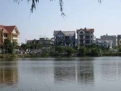
 Hải Dương Location in Vietnam | |
| Coordinates: 20°56′23″N 106°19′50″E / 20.93972°N 106.33056°E | |
| Country |
|
| Province | Hải Dương |
| Area | |
| • Total | 71.38 km2 (27.56 sq mi) |
| Population (2015 est.) | |
| • Total | 400,893 |
| • Density | 5,616/km2 (14,550/sq mi) |
Hải Dương (![]() listen) is a city in Vietnam. It is the capital of Hải Dương, a highly developed and industrialised province located within the Hanoi Metropolitan Area as well as the Red River Delta in Northern Vietnam. Its name is Sino-Vietnamese for "ocean" (海陽). At the midpoint between Hà Nội (Vietnam's capital and second biggest city) and Hải Phòng (Vietnam's third biggest city and a major port), Hải Dương is an important urban area in the Northern Key Economic Zone.
listen) is a city in Vietnam. It is the capital of Hải Dương, a highly developed and industrialised province located within the Hanoi Metropolitan Area as well as the Red River Delta in Northern Vietnam. Its name is Sino-Vietnamese for "ocean" (海陽). At the midpoint between Hà Nội (Vietnam's capital and second biggest city) and Hải Phòng (Vietnam's third biggest city and a major port), Hải Dương is an important urban area in the Northern Key Economic Zone.
Geography
Hai Duong city is bordered to the north-east by the Nam Sách District and Thanh Hà District. A branch of the Cái River (literally, "mother river" in Vietnamese) divides the city into two parts, on one side the urban area, on the other side lie rural and industrial outskirts. It is bordered to the west by the Cẩm Giàng District, and to the south by the Gia Lộc and Tứ Kỳ districts, and also a branch of the Sat River. The city is located in the centre of both the Northern Economic Area and of the Hanoi–Hai Phong–Quang Ninh development region as well. Hải Dương is located 58 kilometres (36 mi) from Hanoi, 45 kilometres (28 mi) from Hai Phong, and 80 kilometres (50 mi) from Halong Bay. A railway, National Highway No.5 (Hanoi - Hải Dương - Hai Phong) and National Highway No.18 (Bắc Ninh - Hải Dương - Quảng Ninh) all pass through the province.
Hải Dương Province is also located within the Red River Delta of northern Vietnam. It is bordered by Hai Phong, Quảng Ninh Province in the east, Hưng Yên in the west, Bắc Ninh and Bắc Giang in the north, and Thái Bình in the south. With a total area of 1,648 square kilometres (636 sq mi), Hải Dương Province has one major city (Hải Dương) and eleven districts (Bình Giang, Cẩm Giàng, Chí Linh, Gia Lộc, Kim Thành, Thanh Hà, Thanh Miện, Nam Sách, Kinh Môn, Ninh Giang, Tứ Kỳ).
Administrative divisions


Hải Dương city was built in 1804, and was first called "Thành Đông" (Sino-Vietnamese for eastern citadel), referring to the citadel east of Vietnam's capital, Hanoi. During the French colonial period, Hải Dương was a town. Before 1968, Hải Dương was a town in the Hải Dương Province. Between 1968 and 1996 it was the capital town of Hải Hưng Province, after the provinces of Hải Dương and Hưng Yên merged to form Hải Hưng. On November 6, 1996, following the separation of Hải Dương and Hưng Yên provinces, Hải Dương became the capital town of the Hải Dương province as it had been before. On August 6, 1997, Hải Dương was established as a city.
From 2013, Hải Dương city includes 17 wards (urban areas) and 4 communes (rural areas).[1]
Precincts
- Bình Hàn
- Cẩm Thượng
- Hải Tân
- Lê Thanh Nghị
- Nhị Châu
- Ngọc Châu
- Nguyễn Trãi
- Phạm Ngũ Lão
- Quang Trung
- Tân Bình
- Thanh Bình
- Trần Hưng Đạo
- Trần Phú
- Tứ Minh
- Việt Hòa
- Ái Quốc
- Thạch Khôi
Communes
- An Châu
- Nam Đồng
- Tân Hưng
- Thượng Đạt
Area and population
| Location | |
|---|---|
| Head office of Committee | No 2 - Dong-xuan str., Tran Phu ward, Haiduong city |
| Size | 13 wards, 6 communes |
| Location | Center of Hải Dương province |
| Inhabitant | |
| Population | 187 405 people |
| Rural | % |
| Urban | % |
| Area | |
| Area | 71.39 square kilometres (27.56 sq mi) |
| Density | 3 815.7 |
| Authorities(2007) | |
| President of Committee | Mr Nguyễn Đức Thăm |
| President of commune | Mr Phạm Công Định |
| Native | Mainly Vietnamese |
| Supplement Information | |
| phone | |
| Fax | |
| Web | Hải Dương |
| Web | Hải Dương |
| Web | Hải Dương |
| Web | Hải Dương |
References
External links
| Wikimedia Commons has media related to Hải Dương. |
Coordinates: 20°56′23″N 106°19′50″E / 20.93972°N 106.33056°E
| Centrally-controlled municipalities |
| ||||||||||
|---|---|---|---|---|---|---|---|---|---|---|---|
| Provincial cities |
| ||||||||||
| Bắc Ninh Province | 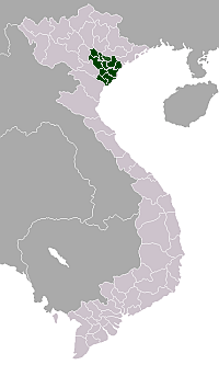 | |
|---|---|---|
| Hà Nam Province | ||
| Hải Dương Province | ||
| Hưng Yên Province | ||
| Nam Định Province | ||
| Ninh Bình Province | ||
| Thái Bình Province | ||
| Vĩnh Phúc Province | ||