Hadley Center Historic District
|
Hadley Center Historic District | |
|
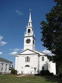
First Congregational Church | |
  | |
| Location | Hadley, Massachusetts |
|---|---|
| Coordinates | 42°20′28″N 72°35′22″W / 42.34111°N 72.58944°WCoordinates: 42°20′28″N 72°35′22″W / 42.34111°N 72.58944°W |
| Built | 1775 |
| Architect | Multiple |
| Architectural style | Mid 19th Century Revival, Early Republic, Colonial Revival |
| NRHP Reference # | [1] (increase) |
| Significant dates | |
| Added to NRHP | December 2, 1977 |
| Boundary increase | January 14, 1994 |
The Hadley Center Historic District is an expansive, 2,500-acre (1,000 ha) historic district encompassing the village center of Hadley, Massachusetts. When it was first listed on the National Register of Historic Places in 1977, the district encompassed the town green and 17 buildings that faced it, at the junction of Russell Street (Massachusetts Route 9) and Middle Street (Massachusetts Route 47).[2] The district was expanded significantly in 1994, adding more than 400 buildings representative of the village's growth from colonial days into the first decades of the 20th century. This expansion encompasses the entirety of a tongue of land extending west from East Street and bounded by a bend in the Connecticut River, which separates Hadley from Northampton. Its oldest property, the Samuel Porter House on West Street, was built in 1713.[3]
See also
- North Hadley Historic District
- Hockanum Rural Historic District
- National Register of Historic Places listings in Hampshire County, Massachusetts
References
- ↑ National Park Service (2008-04-15). "National Register Information System". National Register of Historic Places. National Park Service.
- ↑ "NRHP nomination for Hadley Center Historic District". Commonwealth of Massachusetts. Retrieved 2013-12-18.
- ↑ "NRHP nomination for Hadley Center Historic District Boundary Increase". Commonwealth of Massachusetts. Retrieved 2013-12-18.
| Topics |  | ||||||||||||||||||||||||||||||
|---|---|---|---|---|---|---|---|---|---|---|---|---|---|---|---|---|---|---|---|---|---|---|---|---|---|---|---|---|---|---|---|
| Lists by county | |||||||||||||||||||||||||||||||
| Lists by city |
| ||||||||||||||||||||||||||||||
| Other lists | |||||||||||||||||||||||||||||||
| |||||||||||||||||||||||||||||||