Guadalupe Creek (Santa Clara County)
| Guadalupe Creek | |
| Los Capitancillos Creek[1] | |
| stream | |
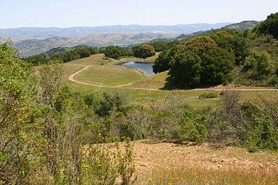 View overlooking man-made Cherry Springs Lake, near Cherry Springs, the origin of Guadalupe Creek's Cherry Springs Creek tributary | |
| Country | United States |
|---|---|
| State | California |
| Region | Santa Clara County |
| Tributaries | |
| - left | Rincon Creek (Santa Clara County, California), Cherry Springs Creek, Pheasant Creek, Shannon Creek |
| - right | Los Capitancillos Creek |
| City | Blossom Valley, San Jose, California |
| Source | Mount Umunhum |
| - location | Santa Clara County, California |
| - elevation | 3,161 ft (963 m) [2] |
| - coordinates | 37°09′31″N 121°53′59″W / 37.15861°N 121.89972°W [1] |
| Mouth | Guadalupe River |
| - elevation | 197 ft (60 m) [1] |
| - coordinates | 37°14′48″N 121°52′16″W / 37.24667°N 121.87111°WCoordinates: 37°14′48″N 121°52′16″W / 37.24667°N 121.87111°W [1] |
Guadalupe Creek is a 10.5 miles (16.9 km) northward-flowing stream originating just east of the peak of Mount Umunhum in Santa Clara County, California, United States. It courses along the northwestern border of Almaden Quicksilver County Park in the Cañada de los Capitancillos before joining Los Alamitos Creek after the latter exits Lake Almaden. This confluence forms the Guadalupe River mainstem, which in turn flows through San Jose, California and empties into south San Francisco Bay at Alviso Slough.
History
The "Valley of the Little Captains" or Rancho Cañada de los Capitancillos is named for the Cañada, or Valley, through which Guadalupe Creek courses.The river was once used for recreation prior to the removal of the Guadalupe Dam.[3]
Watershed and Course
The Guadalupe Creek subwatershed drains 14.8 square miles (38 km2).[4] Heading downstream east from the peak of Mount Umunhum, Guadalupe Creek is joined on the left by Rincon Creek,[5] and then on the right by Los Capitancillos Creek[6] before reaching Guadalupe Reservoir. Guadalupe Dam,[7] built in 1935, formed the Guadalupe Reservoir. The main purpose of the reservoir is to capture runoff from winter storms to recharge in the Alamitos percolation pond system during the summer.[8]
Below Guadalupe Dam, Guadalupe Creek follows Hicks Road and just below the intersection of Reynolds Road is joined on the left first by perennial Cherry Springs (aka Reynolds) Creek which originates at Cherry Springs.[4][9] Cherry Springs Creek has a small perennial tributary, Hicks Creek,[10] which originates on the northern side of El Sombroso Peak[11] and flows into Reynolds Creek from the west.[12] The next Guadalupe River tributary is Pheasant Creek[13] which runs below Hicks Road between Pheasant and Wagner Roads to join Guadalupe Creek from the left. At the intersection of Shannon Road and Hicks Road, Guadalupe Creek is joined from the left next by Shannon Creek.
Masson Dam, built in 1964, is a small diversion dam about 1.3 miles (2.1 km) upstream of Almaden Expressway. The dam conveys water into the Los Capitancillos percolation ponds continually, unless Guadalupe Reservoir spills. If the reservoir spills, diversion operations terminate until the rainy season ends. In 1999, Masson Dam, which had been a complete barrier to fish passage, was removed and then re-built, along with a fish ladder which was completed in 2000.[8] Completed in 1962 and reconstructed in 1964, the Los Capitancillos percolation ponds occupy about 63 acres, from Almaden Expressway (east) to Camden Road (west).
Guadalupe creek crosses Almaden Expressway just before joining Los Alamitos Creek at Lake Almaden, the beginning of the Guadalupe River. Lake Almaden was historically a meadow but was formed by a gravel removing quarry operation. Guadalupe Creek has been entirely earthen since a short 500 foot section of concrete channel was removed near its confluence with Pheasant Creek.
Ecology
Steelhead (Oncorhynchus mykiss) spawned historically in Guadalupe Creek and its Pheasant Creek and Hicks (Cherry Springs) Creek tributaries through the 1950s[14] but construction of Masson Dam formed an impassable barrier. It is not clear whether steelhead use the fish ladder constructed in 2000. Resident rainbow trout persist in the upper Guadalupe Creek above the dam.[14] The creek below Guadalupe Dam supports the western pond turtle (Actinemys marmorata), foothill yellow-legged frog (Rana boylii), yellow warbler, double crested cormorant, and rainbow trout.
Rare flora include Mount Hamilton thistle (Cirsium fontinale var. campylon ), Santa Clara Valley dudleya (Dudleya setchellii)(Endangered), Santa Clara red ribbons (Clarkia concinna automixa), fragrant fritillary (Fritillaria liliacea) and the Mount Hamilton jewelflower (Streptanthus callistus).[8]
Mercury Contamination
Guadalupe Creek is impaired (303(d) listed) by mercury contamination. Historically, workers disposed of roasted mercury mining wastes, called calcines, and other waste in or near Guadalupe Creek and Los Alamitos Creek so that waste materials would be transported downstream by winter flows. Guadalupe Reservoir covers a former mercury ore processing area. Calcines and other mining wastes are still present along the banks of Guadalupe Creek above Camden Avenue, along the banks of upper Guadalupe Creek near the former Guadalupe Mine outside of the Almaden Quicksilver County Park. A partly vegetated mining waste pile is present at Hicks Flat on the opposite side of Guadalupe Creek from the main mine.[4]
A half-mile stretch of Guadalupe Creek between Almaden Expressway and Masson Dam was restored in 2001 as mitigation for the downtown San Jose flood control project. Restoration included removal of mercury-contaminated sediments and recreation of a meandering stream course with native vegetation.[4]
See also
References
- 1 2 3 4 U.S. Geological Survey Geographic Names Information System: Guadalupe Creek
- ↑ U.S. Geological Survey. National Hydrography Dataset high-resolution flowline data. The National Map, accessed April 11, 2013
- ↑ Erwin G. Gudde, William Bright (2004). California Place Names: The Origin and Etymology of Current Geographical Names. University of California Press. p. 53. ISBN 978-0-520-24217-3. Retrieved 2013-05-11.
- 1 2 3 4 TetraTech, Inc. (2005-05-20). Guadalupe River Watershed Mercury TMDL Project (PDF) (Report). Retrieved 2014-07-20.
- ↑ "Rincon Creek (Santa Clara County, California)". Geographic Names Information System. United States Geological Survey.
- ↑ "Los Capitancillos Creek". Geographic Names Information System. United States Geological Survey.
- ↑ "Guadalupe Dam". Geographic Names Information System. United States Geological Survey.
- 1 2 3 Guadalupe Creek (Report). Santa Clara Valley Water District. Retrieved 2013-05-11.
- ↑ "Cherry Springs". Geographic Names Information System. United States Geological Survey.
- ↑ Matt Baldzikowski (2013-12). Hicks Flat Final Project Report (PDF) (Report). San Francisco Estuary Institute. Retrieved 2014-07-26. Check date values in:
|date=(help) - ↑ "El Sombroso". Geographic Names Information System. United States Geological Survey.
- ↑ Sarah Young, Richard McMurtry, Michael Stanley-Jones, Alice Ringer (2003-02). Watershed Assessment Report, Chapter 4: Assessment of Guadalupe Watershed (Report). II. pp. 4–9. Retrieved 2014-07-26. Check date values in:
|date=(help) - ↑ "Pheasant Creek". Geographic Names Information System. United States Geological Survey.
- 1 2 Robert A. Leidy, Gordon S. Becker, Brett N. Harvey. Historical Distribution and Current Status of Steelhead/Rainbow Trout (Oncorhynchus mykiss) in Streams of the San Francisco Estuary, California (PDF) (Report). Oakland, California: Center for Ecosystem Management and Restoration. Retrieved 2013-05-11.