Graffam Development Historic District
|
Graffam Development Historic District | |
|
Abbottsford Road | |
  | |
| Location | Roughly bounded by Abbottsford Rd., Babcock St., Manchester, and Naples Rds., Brookline, Massachusetts |
|---|---|
| Coordinates | 42°20′56″N 71°7′4″W / 42.34889°N 71.11778°WCoordinates: 42°20′56″N 71°7′4″W / 42.34889°N 71.11778°W |
| Area | 9 acres (3.6 ha) |
| Built | 1895 |
| Architect | Greenleaf and Cobb,et al. |
| Architectural style | Colonial Revival, Queen Anne |
| MPS | Brookline MRA |
| NRHP Reference # | [1] |
| Added to NRHP | October 17, 1985 |
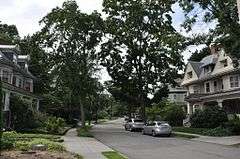
The Graffam Development Historic District encompasses the best-preserved portion of a historic residential subdivision, platted and built between 1894 and 1907. The land was purchased by Peter Graffam, who built a variety of Queen Anne and Colonial Revival houses on Babcock Street, Abbottsford Road, Manchester Road, Stedman Street, and Naples Road in Brookline, Massachusetts. Graffam also developed Osborne Street, but most of its houses have since been modified, losing historic integrity.[2] The district was listed on the National Register of Historic Places in 1985.[1]
See also
References
- 1 2 National Park Service (2008-04-15). "National Register Information System". National Register of Historic Places. National Park Service.
- ↑ "MACRIS inventory record for Graffam Development Historic District". Commonwealth of Massachusetts. Retrieved 2014-05-15.
| Topics |  | ||||||||||||||||||||||||||||||
|---|---|---|---|---|---|---|---|---|---|---|---|---|---|---|---|---|---|---|---|---|---|---|---|---|---|---|---|---|---|---|---|
| Lists by county | |||||||||||||||||||||||||||||||
| Lists by city |
| ||||||||||||||||||||||||||||||
| Other lists | |||||||||||||||||||||||||||||||
| |||||||||||||||||||||||||||||||
This article is issued from Wikipedia - version of the 11/27/2016. The text is available under the Creative Commons Attribution/Share Alike but additional terms may apply for the media files.