Porth Dafarch
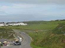
Porth Dafarch is a sandy beach resort on the west coast of Ynys Môn (Isle of Anglesey), north Wales, close to Holyhead. It is a south-facing cove in the west of Holy Island, Anglesey, some 2 mi (3.2 km) southwest of Holyhead and 1.5 mi (2.4 km) west of Trearddur Bay.[1]
The bay is roughly 100 metres across and opens out southwest into the Irish Sea. Backed by cliffs and in close proximity to campsites, it features a sheltered and marked bathing area, there are opportunities for walking and the beach is a popular destination for rock-pooling.[2] It is also popular for watersports, particularly windsurfing, surfing, canoeing, sailing and jet skiing. Scuba divers are able to view a 3000-ton vessel, the Missouri, which was wrecked here in 1886 on its way to Boston.[3]
From the mid-seventeenth to the mid-nineteenth centuries, the main mail route to Ireland was via Holyhead. Porth Dafarch was used as an alternative port for despatch of the mail across the Irish Sea to Dublin at such times as the port of Holyhead was affected by adverse sea conditions. However, with the commencement of a steam service in 1822, the alternative port was no longer needed.[4]
The origins of the name are uncertain. Although some claim that the placename is a contraction of Porth Dau Farch ("Harbour of the Two Stallions"), scholars are fairly sure that this is not the case. Indeed, in documents the name has been recorded as Porth Davagh ("Davagh's Harbour") (1545), Porth Daverch (1878), Porth y Dafarch (1799), Porth y Daferch (1789), and the present Porth Dafarch (since 1838).[5] It has been tentatively suggested that "Tafarch" (which takes a soft mutation after porth to become "Dafarch") was a personal name, albeit not a common one.[6]
References
- ↑ OS Landranger 114: Anglesey / Ynys Môn. Ordnance Survey. 2016. ISBN 978-0-319-26212-2.
- ↑ Martin, Kate. "The joys of rockpooling". The National Trust. Retrieved 14 June 2016.
- ↑ "Porth Dafarch Beach". North Wales Holiday Cottages. Retrieved 14 June 2016.
- ↑ Ayres, George (2011). History of the Mail Routes to Ireland Until 1850. Lulu.com. p. 84. ISBN 978-1-4466-0504-2.
- ↑ "Melville Richards Archive Place-Name Database". Place Name Research Centre. Archif Melvyn Richards. Retrieved 14 June 2016.
- ↑ "Ynys Môn: Enwau llefydd". BBC Lleol, Gogledd Orllewin. Retrieved 14 June 2016.
External links
![]() Media related to Porth Dafarch at Wikimedia Commons
Media related to Porth Dafarch at Wikimedia Commons
Coordinates: 53°17′12″N 4°39′08″W / 53.2867°N 4.6521°W
