Grade I and II* listed buildings in Barnet
There are over 9,000 Grade I listed buildings and 20,000 Grade II* listed buildings in England. This page is a list of these buildings in the London Borough of Barnet.
Grade I
| Name | Location | Type | Completed [note 1] | Date designated | Grid ref.[note 2] Geo-coordinates |
Entry number [note 3] | Image |
|---|---|---|---|---|---|---|---|
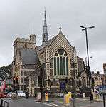
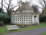
| Church of St Jude | Hampstead Garden Suburb | Church | 1908–10 | 18 March 1965 | TQ2551688361 51°34′49″N 0°11′24″W / 51.580143°N 0.189945°W |
1294714 |  |
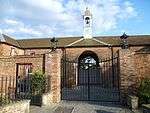
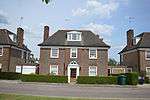
| The Free Church | Hampstead Garden Suburb | Nonconformist chapel | 1908–10 | 18 March 1965 | TQ2544988471 51°34′52″N 0°11′27″W / 51.581146°N 0.190872°W |
1078866 |  |
Grade II*


| Wikimedia Commons has media related to Grade I listed buildings in the London Borough of Barnet. |
| Wikimedia Commons has media related to Grade II* listed buildings in the London Borough of Barnet. |
Notes
- 1 2 The date given is the date used by Historic England as significant for the initial building or that of an important part in the structure's description.
- 1 2 Sometimes known as OSGB36, the grid reference is based on the British national grid reference system used by the Ordnance Survey.
- 1 2 The "List Entry Number" is a unique number assigned to each listed building and scheduled monument by Historic England.
References
This article is issued from Wikipedia - version of the 10/1/2016. The text is available under the Creative Commons Attribution/Share Alike but additional terms may apply for the media files.