New Barnet
| New Barnet | |
 Station Approach, New Barnet |
|
 New Barnet |
|
| OS grid reference | TQ265955 |
|---|---|
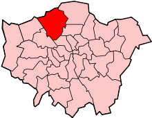
| London borough | Barnet |
| Ceremonial county | Greater London |
| Region | London |
| Country | England |
| Sovereign state | United Kingdom |
| Post town | BARNET |
| Postcode district | EN4, EN5 |
| Dialling code | 020 |
| Police | Metropolitan |
| Fire | London |
| Ambulance | London |
| EU Parliament | London |
| UK Parliament | Chipping Barnet |
| London Assembly | Barnet and Camden |
Coordinates: 51°38′38″N 0°10′15″W / 51.6440°N 0.1708°W
New Barnet is an area within the London Borough of Barnet. It is a largely residential North London suburb, close to the M25, A1 and M1.
History
New Barnet owes its conception to the building of the Great Northern Railway in 1850, when a station serving High Barnet was built, but located about a mile away from the town centre of High Barnet, so that this 'new' area quickly saw development. The main road (A110), Station Road and East Barnet Road, connects Barnet to East Barnet and is well served by buses.
From 1894 New Barnet formed part of the East Barnet Urban District of Hertfordshire until 1965 when it was transferred from Hertfordshire to Greater London to become part of the newly created London Borough of Barnet. The former town hall still stands in Station Road. Local government use ended in the early 1990s and the property was sold off for use as a restaurant. In 2006 the building was being converted into flats.
The main commercial area in New Barnet is on East Barnet Road, near the railway station. A number of office blocks were built in Station Road in the 1960s & 70s. Some have now been converted to flats. A large Sainsbury's supermarket (opened 30 September 1980) is surrounded by a cluster of small independent shops. These local shops are under threat of demolition from large schemes planned by Tesco and Asda stores. Although there is some local concern about the two planned developments,[1] many residents have noted that the town centre urgently requires some sort of redevelopment.[2]
Public houses in New Barnet include The Railway Tavern, The Railway Bell (Wetherspoons) The Builders Arms and The Lord Kitchener.
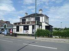
As of 2015, The Alexandra pub in East Barnet Road is due to be demolished and replaced by an apartment block.[3]
Geography
 |
Monken Hadley | Hadley Wood | Cockfosters | |
| High Barnet | |
East Barnet | ||
| ||||
| | ||||
| Whetstone | Oakleigh Park | Osidge |
Local government
Barnet local elections are held every four years to elect councillors. New Barnet is covered by three wards:
- East Barnet Ward
- High Barnet Ward
- Oakleigh Ward
Transport
Buses
London Buses serving New Barnet are:
| Route | Start | End | Operator |
| 84 not a London bus route |
New Barnet | St Albans | Metroline |
| 107 | New Barnet | Edgware | Metroline |
| 184 | Barnet | Turnpike Lane Station | Arriva London |
| 307 | Barnet | Brimsdown | Arriva London |
| 326 | Barnet | Brent Cross | London Sovereign |
| 383 | Barnet | Woodside Park | Uno (bus company) |
| 384 | Barnet | Cockfosters | Metroline |
| 714 | New Barnet | Luton via Luton Airport | Metroline[4] |
Trains
Stations in the area are:
Schools
Primary
- Livingstone School
- Cromer Road School
- Trent School
- Lyonsdown School (Independent) 49 in top 100 primary schools
Secondary
- Jewish Community Secondary School (Jcoss)
- East Barnet School (EBS)
See also
- John Sebastian Marlowe Ward who founded a folk museum in Park Road.
References
- ↑ "Keeping watch on developments". New Barnet. Retrieved 2015-12-07.
- ↑ "Local Issues - A Vision For". New Barnet. Retrieved 2015-12-07.
- ↑ "Newsletter, 30th June 2014" (PDF). Save New Barnet Campaign. 30 June 2014. Retrieved 7 December 2015.
- ↑ "Route 714 New Barnet - St Albans - Luton Airport - Luton". Metroline. Retrieved 2015-06-30.
External links
![]() Media related to New Barnet at Wikimedia Commons
Media related to New Barnet at Wikimedia Commons