Grade II* listed buildings in Rhondda Cynon Taf
Rhondda Cynon Taf shown within Wales
In the United Kingdom, the term listed building refers to a building or other structure officially designated as being of special architectural, historical, or cultural significance; Grade II* structures are those considered to be "particularly important buildings of more than special interest".[1] Listing was begun by a provision in the Town and Country Planning Act 1947. Once listed, strict limitations are imposed on the modifications allowed to a building's structure or fittings. In Wales, the authority for listing under the Planning (Listed Buildings and Conservation Areas) Act 1990[2] rests with Cadw.
Buildings
| Name | Location | Date Listed | Grid Ref.[note 1] Geo-coordinates |
Function | Notes | HB No[note 2] | Image |
|---|---|---|---|---|---|---|---|
| St Elvan's Church, Aberdare | Aberdare | 14 September 1961 | SO0025602590 51°42′47″N 3°26′42″W / 51.713165896176°N 3.4451118638908°W |
Church | Prominently set in a small churchyard on an eminence in the centre of the town. Reached from Victoria Square, up Church Street and from Canon Street. | 10841 | 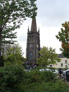
|
| St John the Baptist Parish Church, Aberdare | Aberdare | 14 September 1961 | SN9999802668 51°42′50″N 3°26′56″W / 51.713820956369°N 3.4488673116465°W |
Church | 10848 | 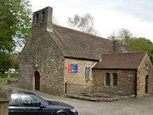
| |
| Tynewydd Farm House | Treherbert | 23 March 1972 | SS9342598864 51°40′42″N 3°32′34″W / 51.678418423346°N 3.5428075734711°W |
Farmhouse | A single house, set within a walled garden on the S facing slope of the valley above the River Rhondda and the later development of the town with access from the street known as Mountain View. | 13115 | 
|
| Ebenezer Welsh Independent Chapel | Tonypandy | 22 May 1978 | SS9953292272 51°37′13″N 3°27′09″W / 51.62029522158°N 3.4526173435837°W |
Chapel | Situated on the main thoroughfare in a commanding position above the road and next to the Police Station. | 13117 | 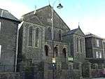
|
| Former Lewis Merthyr Colliery lamproom and fan house | Trehafod | 16 August 1984 | ST0397991140 51°36′39″N 3°23′17″W / 51.610897854451°N 3.388092639324°W |
Colliery fan house | Located between the 2 headframes at the N side of the main colliery yard. | 13119 | 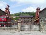
|
| Former Lewis Merthyr Colliery Bertie pithead, headframe, tram circuit and tippler | Trehafod | 16 August 1984 | ST0395791132 51°36′39″N 3°23′18″W / 51.610822185626°N 3.3884080583185°W |
Colliery headstock | Located at NW corner of complex | 13120 | .jpg)
|
| Former Lewis Merthyr Colliery Bertie winding engine house | Trehafod | 16 August 1984 | ST0396391100 51°36′38″N 3°23′18″W / 51.610535574685°N 3.3883126592423°W |
Colliery engine house | Located facing Coedcae Road at the W side of complex. | 13124 | 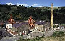
|
| Former Lewis Merthyr Colliery Trefor pithead and headframe | Trehafod | 16 August 1984 | ST0399491143 51°36′39″N 3°23′16″W / 51.610927383325°N 3.387876907253°W |
Colliery headstock | Located on the N side of the complex, the eastern of the 2 pitheads. | 13121 | 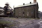
|
| Former Lewis Merthyr Colliery Trefor winding engine house | Trehafod | 16 August 1984 | ST0400391113 51°36′38″N 3°23′16″W / 51.61065926172°N 3.3877387489393°W |
Colliery engine house | Located next to Coedcae Road at the centre of the complex. | 13122 |
|
| St Peter's Church, Pentre | Pentre | 9 December 1991 | SS9695196179 51°39′18″N 3°29′28″W / 51.654944544531°N 3.4910369145175°W |
Church | Situated in a sloping rectangular churchyard, the W end fronting Llewellyn Street, the main thoroughfare. | 13126 | 
|
| Bethesda Welsh Independent Chapel | Ton Pentre | 30 June 1993 | SS9709695376 51°38′52″N 3°29′19″W / 51.647753651929°N 3.4887050771042°W |
Chapel | Situated on an island site within the grid pattern of the neighbouring streets in this central area of Ton Pentre just W of the river and railway crossing and adjacent to the churchyard of St John Ystradyfodwg. | 13128 | 
|
| Llanharan House | Llanharan | 22 February 1963 | ST0072283221 51°32′21″N 3°25′58″W / 51.539151814195°N 3.4328724417395°W |
House | Set in open parkland above and on the N side of the A473 0.5km E of Llanharan village. | 13156 | 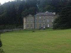
|
| Castellau House | Llantrisant | 28 August 1977 | ST0505986523 51°34′10″N 3°22′17″W / 51.569580392009°N 3.3712501149993°W |
House | Located on the E side of a narrow lane which runs N from Castellau to Gelli-wion and on to Pontypridd. | 13503 |
|
| Former Casting House and Workshop at Treforest Tinplate Works | Treforest, Pontypridd | 27 October 1980 | ST0867188196 51°35′07″N 3°19′11″W / 51.585216678561°N 3.3195853530291°W |
Casting house | At the N end of the former tinplate works. | 13506 |
|
| Workshop NW of Tinning House at Treforest Tinplate Works | Treforest, Pontypridd | 27 October 1980 | ST0866788155 51°35′05″N 3°19′11″W / 51.584847482801°N 3.3196323899622°W |
Workshop | On the NW side of the former tinplate works. | 13507 |
|
| Former Tinning House at Treforest Tinplate Works | Treforest, Pontypridd | 27 October 1980 | ST0870388101 51°35′04″N 3°19′09″W / 51.584367924959°N 3.3190988806944°W |
Tinning house | On the N side of the former rolling mill. | 13508 | 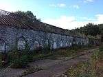
|
| Former Smithy at Treforest Tinplate Works | Treforest, Pontypridd | 27 October 1980 | ST0876887987 51°35′00″N 3°19′05″W / 51.583353732664°N 3.3181313357226°W |
On the E side of the former rolling mill. | 13509 |
| |
| Former Rolling Mill at Treforest Tinplate Works | Treforest, Pontypridd | 27 October 1980 | ST0871887961 51°34′59″N 3°19′08″W / 51.583111908289°N 3.3188460005574°W |
Rolling Mill | At the S end of Treforest and reached across a bridge over the Taff W of Cardiff Road. The rolling mill is at the S end of the former works. | 13510 | 
|
| Talygarn | Pont-y-Clun | 30 January 1981 | ST0317080046 51°30′40″N 3°23′48″W / 51.511038656692°N 3.3967128163262°W |
House | In extensive grounds reached by a drive off the E side of the A4222 Cowbridge Road S of the M4 and Pontyclun village. | 13511 |
|
| Municipal Buildings, Pontypridd | Pontypridd | 17 January 1990 | ST0724390394 51°36′17″N 3°20′27″W / 51.60474046341°N 3.3407719778562°W |
Offices | To the NW of the town centre. The main entrance front faces S to Chapel Street, which turns back along rear elevation. | 13532 | 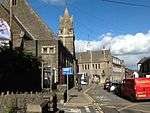
|
| Cwm Coke Works Northern Cooling Tower | Llantwit Fardre | 24 November 1993 | ST0658586115 51°33′58″N 3°20′57″W / 51.566168319019°N 3.3491303513907°W |
Coke works | One of a pair of wooden cooling towers located opposite the offices in the centre of Cwm Coke Works. The second tower is aligned and about 10m to the S. | 13537 | 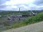
|
| Cwm Coke Works Southern Cooling Tower | Llantwit Fardre | 24 November 1993 | ST0658486095 51°33′58″N 3°20′57″W / 51.565988375971°N 3.3491394518283°W |
Cooling Tower | One of a pair of wooden cooling towers located opposite the offices in the centre of Cwm Coke Works. Immediately to the S of and aligned with the larger northern tower. | 13538 |
|
| Evan Howells Butchers Shop | Porth | 8 January 1996 | ST0271091207 51°36′41″N 3°24′23″W / 51.611281813106°N 3.4064316672903°W |
Shop | Situated on the NE side of Hannah Street in the town centre. Part of the former Thomas and Evans complex of shops, Nos. 22–25 which are listed separately. | 17115 |
|
| Ysgoldy Ebenezer attached to left of Ebenezer Welsh Independent Chapel | Tonypandy | 22 May 1978 | SS9953692256 51°37′13″N 3°27′09″W / 51.620152123018°N 3.4525549921143°W |
Schoolhouse | Situated on the main thoroughfare in a commanding position above the road and next to the Police Station. | 17332 | 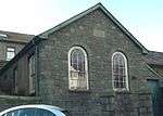
|
| Parc and Dare Hall | Treorchy | 20 December 1996 | SS9590096659 51°39′33″N 3°30′23″W / 51.659064803953°N 3.5063671919699°W |
Town House | Situated just off High Street/Bute Street in a central position in the town by the main railway and river crossing and Treorchy station and at the entrance to the Cwmparc valley; separate frontages on Dyfodwg Street and Station Street. | 18064 | 
|
| Elim Pentecostal Church, Mountain Ash | Mountain Ash | 18 February 1999 | ST0474299063 51°40′56″N 3°22′45″W / 51.682244558792°N 3.3792372841423°W |
Church | Situated in a terrace in Knight Street, some 30 m uphill from its junction with the A4059. | 21372 | .jpg)
|
| Church of St Illtyd, St Gwynno and St Dyfodwg | Llantrisant | 18 August 2000 | ST0464083425 51°32′30″N 3°22′35″W / 51.54166235104°N 3.3764526586447°W |
Church | Located in an elevated position towards the centre of the village and to the W of the castle. | 23942 | 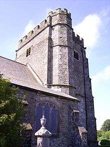
|
| Memorial to Evan and James James at Ynysangharad Park | Pontypridd | 26 February 2001 | ST0754590141 51°36′09″N 3°20′11″W / 51.602516044797°N 3.3363457240057°W |
Memorial | Ynysyngharad Park is on the E side of the town centre and River Taff. The memorial is on the E side of the park N of the bandstand. | 24841 | 
|
| Taff Vale Railway Viaduct over Mill Street including masonry weir | Pontypridd | 26 February 2001 | ST0704990068 51°36′06″N 3°20′37″W / 51.601778059354°N 3.3434859127288°W |
Bridge | Spanning the River Rhondda to the W of the town centre. | 24845 | 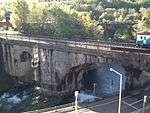
|
| White Bridge, Pontypridd | Pontypridd | 26 February 2001 | ST0774991043 51°36′38″N 3°20′01″W / 51.610657503588°N 3.3336386718276°W |
Bridge | Spanning the River Taff approximately 0.7km NNE of Pontypridd Bridge. | 24848 | 
|
| Church of St Catherine, Pontypridd | Pontypridd | 26 February 2001 | ST0714090150 51°36′09″N 3°20′32″W / 51.602530183277°N 3.3421941241127°W |
Church | Prominently sited in its own churchyard raised above the level of Gelliwastad Road. | 24860 | 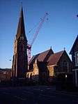
|
| Fan House at Hetty Shaft | Pontypridd | 8 March 1984 | ST0545090910 51°36′33″N 3°22′00″W / 51.609079884791°N 3.3667935808596°W |
Colliery Fan House | On the W side of the engine house. | 24871 | 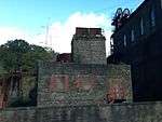
|
| Leat Retaining Wall at Treforest Tinplate Works | Treforest, Pontypridd | 27 October 1980 | ST0871087950 51°34′59″N 3°19′08″W / 51.583011731652°N 3.3189585655187°W |
Wall | Parallel with and detached from the W side of the former rolling mill. | 24882 |
|
| Machine Bridge, Pontypridd | Treforest, Pontypridd | 26 February 2001 | ST0839489287 51°35′42″N 3°19′26″W / 51.594978532247°N 3.3238673739638°W |
Bridge | Spanning the River Taff at the SE end of Broadway and E of St Dyfrig's Church. | 24912 | 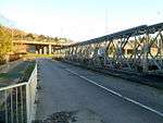
|
| Llwydcoed Crematorium | Llwydcoed | 16 March 2007 | SN9944306538 51°44′55″N 3°27′29″W / 51.74850581282°N 3.4580169476437°W |
Crematorium | Between Merthyr and Hirwaun, on minor road off A465, on S slope of hillside, set in extensive landscaped grounds. | 87523 | 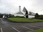 |
Notes
- ↑ Sometimes known as OSGB36, the grid reference is based on the British national grid reference system used by the Ordnance Survey.
- ↑ The "HB Number" is a unique number assigned to each listed building by Cadw.
See also
References
- ↑ "Buildings & Conservation Areas". Cadw. Retrieved 18 June 2013.
- ↑ "Planning (Listed Buildings and Conservation Areas) Act 1990". The National Archives. Retrieved 18 June 2013.
External links
![]() Media related to Grade II* listed buildings in Rhondda Cynon Taf at Wikimedia Commons
Media related to Grade II* listed buildings in Rhondda Cynon Taf at Wikimedia Commons
This article is issued from Wikipedia - version of the 1/16/2016. The text is available under the Creative Commons Attribution/Share Alike but additional terms may apply for the media files.