Gouda, Western Cape
| Gouda | |
|---|---|
|
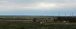
A skyline of the town of Gouda in the Western Cape, South Africa. Part of the Gouda Wind Farm can be seen to the far right of the picture. | |
 Gouda  Gouda  Gouda
| |
| Coordinates: 33°18′S 19°02′E / 33.300°S 19.033°ECoordinates: 33°18′S 19°02′E / 33.300°S 19.033°E | |
| Country | South Africa |
| Province | Western Cape |
| District | Cape Winelands |
| Municipality | Drakenstein |
| Area[1] | |
| • Total | 7.65 km2 (2.95 sq mi) |
| Population (2011)[1] | |
| • Total | 3,441 |
| • Density | 450/km2 (1,200/sq mi) |
| Racial makeup (2011)[1] | |
| • Black African | 8.5% |
| • Coloured | 90.0% |
| • Indian/Asian | 0.2% |
| • White | 1.3% |
| • Other | 0.1% |
| First languages (2011)[1] | |
| • Afrikaans | 90.7% |
| • Xhosa | 4.9% |
| • English | 1.6% |
| • Other | 2.8% |
| PO box | 6821 |
| Area code | 023 |
Gouda is a settlement in Cape Winelands District Municipality in the Western Cape province of South Africa.
The town lies some 38km south of Porterville, 14km west of Tulbagh and 61km north-west of Worcester. Prior to 1929, it was known as Porterville Road. Of Khoekhoen origin, the name Gouda is said to mean ‘antelope’. Another possible translation is ‘honey path’, ‘honey defile’.[2] It is unrelated to the Dutch city of the same name.
The 138 MW Gouda Wind Farm, opened in September 2015, is situated just outside the town.[3]
References
- 1 2 3 4 "Main Place Gouda". Census 2011.
- ↑ "Dictionary of Southern African Place Names (Public Domain)". Human Science Research Council. p. 184.
- ↑ Gosling, Melanie (9 September 2015). "Another wind farm joins the grid". Cape Times. Retrieved 12 September 2015.
Municipalities and communities of Cape Winelands District Municipality, Western Cape | ||
|---|---|---|
District seat: Stellenbosch | ||
| Witzenberg | .svg.png) | |
| Drakenstein | ||
| Stellenbosch | ||
| Breede Valley | ||
| Langeberg | ||
This article is issued from Wikipedia - version of the 10/2/2016. The text is available under the Creative Commons Attribution/Share Alike but additional terms may apply for the media files.