Drakenstein Local Municipality
| Drakenstein | ||
|---|---|---|
| Local municipality | ||
| ||
.svg.png) Location in the Western Cape | ||
| Coordinates: 33°30′S 19°00′E / 33.500°S 19.000°ECoordinates: 33°30′S 19°00′E / 33.500°S 19.000°E | ||
| Country | South Africa | |
| Province | Western Cape | |
| District | Cape Winelands | |
| Seat | Paarl | |
| Wards | 31 | |
| Government[1] | ||
| • Type | Municipal council | |
| • Mayor | Conrad Poole (DA) | |
| Area | ||
| • Total | 1,538 km2 (594 sq mi) | |
| Population (2011)[2] | ||
| • Total | 251,262 | |
| • Density | 160/km2 (420/sq mi) | |
| Racial makeup (2011)[2] | ||
| • Black African | 22.7% | |
| • Coloured | 62.5% | |
| • Indian/Asian | 0.4% | |
| • White | 13.5% | |
| First languages (2011)[3] | ||
| • Afrikaans | 75.0% | |
| • Xhosa | 16.7% | |
| • English | 5.1% | |
| • Other | 3.2% | |
| Time zone | SAST (UTC+2) | |
| Municipal code | WC023 | |

Drakenstein Municipality is a local municipality located within the Cape Winelands District Municipality, in the Western Cape province of South Africa. As of 2011 it had a population of 251,262.[2] Its municipality code is WC023.
Geography
The municipality covers a total area of 1,538 square kilometres (594 sq mi) in the valley of the Berg River to the west of the Boland mountain ranges. It stretches about 75 kilometres (47 mi) from Saron in the north to beyond Paarl in the south. It abuts on the Witzenberg Municipality and Breede Valley Municipality to the east, the Stellenbosch Municipality to the south, the City of Cape Town and the Swartland Municipality to the west, and the Bergrivier Municipality to the north.
According to the 2011 census the municipality has a population of 251,262 people in 59,774 households. Of this population, 62.5% describe themselves as "Coloured", 22.7% as "Black African", and 13.5% as "White". The first language of 75.0% of the population is Afrikaans, while 16.7% speak Xhosa and 5.1% speak English.[4]
The principal town and location of the municipal headquarters is Paarl, situated in the south of the municipality, which as of 2011 has a population of 112,045 people. Paarl is the southernmost part of a continuous built-up area along the Berg River which also includes Mbekweni (pop. 30,875) and Wellington (pop. 55,543). In the northern part of the municipality are the smaller towns of Gouda (pop. 3,441) and Saron (pop. 7,843).
Politics
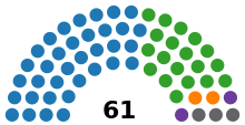
The municipal council consists of sixty-one members elected by mixed-member proportional representation. Thirty-one councillors are elected by first-past-the-post voting in thirty-one wards, while the remaining thirty are chosen from party lists so that the total number of party representatives is proportional to the number of votes received. In the election of 18 May 2011 the Democratic Alliance (DA) obtained a majority of thirty-five seats on the council.
The following table shows the results of the 2011 election.[5][6]
| Party | Votes | Seats | ||||||
|---|---|---|---|---|---|---|---|---|
| Ward | List | Total | % | Ward | List | Total | ||
| Democratic Alliance | 41,828 | 42,707 | 84,535 | 56.9 | 22 | 13 | 35 | |
| African National Congress | 22,604 | 23,214 | 45,818 | 30.8 | 9 | 10 | 19 | |
| National People's Party | 2,833 | 2,691 | 5,524 | 3.7 | 0 | 2 | 2 | |
| Congress of the People | 2,304 | 2,336 | 4,640 | 3.1 | 0 | 2 | 2 | |
| Independent | 1,743 | – | 1,743 | 1.2 | 0 | – | 0 | |
| African Christian Democratic Party | 679 | 801 | 1,480 | 1.0 | 0 | 1 | 1 | |
| South African Progressive Civic Organisation | 564 | 502 | 1,066 | 0.7 | 0 | 1 | 1 | |
| People's Democratic Movement | 551 | 459 | 1,010 | 0.7 | 0 | 1 | 1 | |
| United Christian Democratic Party | 329 | 283 | 612 | 0.4 | 0 | 0 | 0 | |
| Khoisan Party | 262 | 298 | 560 | 0.4 | 0 | 0 | 0 | |
| Democratic Christian Party | 207 | 307 | 514 | 0.3 | 0 | 0 | 0 | |
| Freedom Front Plus | 298 | 214 | 512 | 0.3 | 0 | 0 | 0 | |
| African Bond of Unity | 146 | 120 | 266 | 0.2 | 0 | 0 | 0 | |
| Western Cape Community | 93 | 113 | 206 | 0.1 | 0 | 0 | 0 | |
| National Independent Civic Organisation | 22 | 124 | 146 | 0.1 | 0 | 0 | 0 | |
| Total | 74,463 | 74,169 | 148,632 | 100.0 | 31 | 30 | 61 | |
| Spoilt votes | 674 | 893 | 1,567 | |||||
The local council sends eight representatives to the council of the Cape Winelands District Municipality: five from the Democratic Alliance and three from the African National Congress.[7]
References
- ↑ "Contact list: Executive Mayors". Government Communication & Information System. Retrieved 22 February 2012.
- 1 2 3 "Statistics by place". Statistics South Africa. Retrieved 27 September 2015.
- ↑ "Statistics by place". Statistics South Africa. Retrieved 27 September 2015.
- ↑ "Drakenstein Local Municipality". Census 2011.
- ↑ "Results Summary – All Ballots: Drakenstein" (PDF). Independent Electoral Commission. Retrieved 14 July 2012.
- ↑ "Seat Calculation Detail: Drakenstein" (PDF). Independent Electoral Commission. Retrieved 14 July 2012.
- ↑ "Political composition of councils" (PDF). Western Cape Department of Local Government. August 2012. Retrieved 17 August 2012.
External links
Municipalities and communities of Cape Winelands District Municipality, Western Cape | ||
|---|---|---|
District seat: Stellenbosch | ||
| Witzenberg | .svg.png) | |
| Drakenstein | ||
| Stellenbosch | ||
| Breede Valley | ||
| Langeberg | ||