Georgia State Route 88
| ||||
|---|---|---|---|---|
 | ||||
| Route information | ||||
| Maintained by GDOT | ||||
| Length: | 53.2 mi[1] (85.6 km) | |||
| Major junctions | ||||
| West end: |
| |||
|
| ||||
| East end: |
| |||
| Location | ||||
| Counties: | Washington, Jefferson, Burke, Richmond | |||
| Highway system | ||||
| ||||

State Route 88 (SR 88) is a 53.2-mile-long (85.6 km) state highway that runs southwest-to-northeast through portions of Washington, Jefferson, Burke, and Richmond counties in the east-central part of the U.S. state of Georgia. The route connects Sandersville and Hephzibah, via Wrens.
Most, if not all, of SR 88 is currently, or will eventually be, part of the Fall Line Freeway, a highway being constructed from Columbus to Augusta, as a connecting link for the two cities and as a truck route.[2] It may also become part of the proposed routing of Interstate 14 (I-14), an Interstate Highway that is slated to connect Natchez, Mississippi with Augusta.
Route description
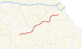
SR 88 begins at an intersection with SR 24, just east of Sandersville, in the central part of Washington County. It heads northeast to an intersection with the northern terminus of SR 231 (Tree Nursery Road), north-northwest of Davisboro. This is just before the highway crosses over the Ogeechee River into Jefferson County. Not too far into the county is an intersection with SR 171 (Grange Road). South of Stapleton is SR 296. SR 88 continues to the northwest, until it meets US 1/US 221/SR 4/SR 17 in the extreme southwestern part of Wrens. The five highways travel concurrent farther into town. At Thompson Road, SR 17 departs to the north-northwest. A few blocks later, SR 80 (Stapleton Highway) intersects with the concurrency. At this intersection, SR 80/SR 88 head to the east. At Waynesboro Road, SR 80 departs to the south-southeast, while SR 88 continues its east-northeastern routing. Then, it gradually curves to a near-due-eastern jaunt, before heading southeast at Matthews. After that, it heads east-northeast, and then northeast, until it crosses into Burke County, just before it meets SR 305. Here, it heads north-northeast, and straddles the county line for a short distance, into Keysville. The road briefly heads north-northwest before it turns to the northeast and enters Richmond County. It enters the town of Blythe and has a unique intersection with US 1/SR 4. This intersection resembles the letter "K", but with a very short horizontal line connecting its upright parts. SR 88 curves to the southeast, before curving to the northeast and entering Hephzibah. On the northeastern edge of town, it meets its eastern terminus, an intersection with US 25/SR 121.[1]
All of SR 88, from its western terminus to where it leaves the US 1/SR 4 concurrency in Wrens, is part of the National Highway System, a system of roadways important to the nation's economy, defense, and mobility.[3][4]
Future
The route of SR 88 is being absorbed into the Fall Line Freeway, which is planned to extend from the Alabama state line in Columbus to an interchange with Interstate 520 in Augusta.[2] It could also become part of the future I-14.
Major intersections
| County | Location | mi[1] | km | Destinations | Notes |
|---|---|---|---|---|---|
| Washington | | 0.0 | 0.0 | Western terminus | |
| | 9.1 | 14.6 | Northern terminus of SR 231 | ||
| Ogeechee River | 10.6 | 17.1 | Fenns Bridge | ||
| Jefferson | Grange | 13.6 | 21.9 | ||
| | 23.1 | 37.2 | |||
| Wrens | 27.1 | 43.6 | Western end of US 1/US 221/SR 4/SR 17 concurrency | ||
| 28.3 | 45.5 | Eastern end of SR 17 concurrency | |||
| 28.6 | 46.0 | Eastern end of US 1/US 221/SR 4 concurrency; western end of SR 80 concurrency | |||
| 29.1 | 46.8 | Eastern end of SR 80 concurrency | |||
| Burke | | 38.3 | 61.6 | Northern terminus of SR 305 | |
| Richmond | Blythe | 44.9 | 72.3 | ||
| Hephzibah | 53.2 | 85.6 | Eastern terminus | ||
1.000 mi = 1.609 km; 1.000 km = 0.621 mi
| |||||
See also
-
.svg.png) Georgia (U.S. state) portal
Georgia (U.S. state) portal -
 U.S. Roads portal
 - Central Savannah River Area
References
- 1 2 3 Google (July 21, 2013). "Route of SR 88" (Map). Google Maps. Google. Retrieved July 21, 2013.
- 1 2 "Fall Line Freeway" (PDF) (Press release). Georgia Department of Transportation. September 2012. Retrieved July 21, 2013.
- ↑ "National Highway System: Georgia" (PDF). United States Department of Transportation. October 1, 2012. Retrieved July 21, 2013.
- ↑ "National Highway System: Augusta-Richmone County, GA–SC" (PDF). United States Department of Transportation. October 1, 2012. Retrieved July 21, 2013.