Burke County, Georgia
| Burke County, Georgia | |
|---|---|
 Burke County courthouse in Waynesboro, Georgia | |
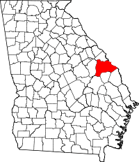 Location in the U.S. state of Georgia | |
 Georgia's location in the U.S. | |
| Founded | 1777 |
| Named for | Edmund Burke[1] |
| Seat | Waynesboro |
| Largest city | Waynesboro |
| Area | |
| • Total | 835 sq mi (2,163 km2) |
| • Land | 827 sq mi (2,142 km2) |
| • Water | 8.0 sq mi (21 km2), 1.0% |
| Population (est.) | |
| • (2015) | 22,745 |
| • Density | 27/sq mi (10/km²) |
| Congressional district | 12th |
| Time zone | Eastern: UTC-5/-4 |
| Website |
www |
Burke County is a county located along the eastern border of the U.S. state of Georgia in the Piedmont. As of the 2010 census, the population was 23,316.[2] The county seat is Waynesboro.[3]
Burke County is part of the Augusta-Richmond County, GA-SC Metropolitan Statistical Area.
History
Burke County is an original county of Georgia, created February 5, 1777. In 1779, Col. John Twiggs and Col. William Few and Benjamin Few, along with 250 men, victoriously defended the Cause of the American Revolution at the Battle of Burke Jail. During the American Civil War, Burke County provided the 2nd Regiment Georgia Infantry Company D (Burke Sharpshooters), 3rd Regiment Georgia Infantry Company A (Burke Guards), 32nd Regiment Georgia Infantry Company C (Williams Volunteers), 32nd Regiment Georgia Infantry Company K (Alexander Greys), 48th Regiment Georgia Infantry Company D (Burke Volunteers), Cobb's Legion Infantry company E (Poythress Volunteers) and the Cobb's Legion Cavalry Company F (Grubb's Hussars).
Burke County is located within the CSRA (the Central Savannah River Area) and was developed for large cotton plantations in the antebellum period. The county became majority African American in population, as most laborers were slaves. It continued to rely on agriculture for decades after the American Civil War.[4] In the early 20th century, mechanization of agriculture caused many workers to lose their jobs.
As can be seen from the census tables below, the county lost population from 1910-1920, and from 1930-1970. Part of the outflow was related to the Great Migration, as millions of African Americans left the rural South and Jim Crow segregation for jobs and opportunities in the Midwest, North, and from World War II on, the West Coast. In addition, whites left rural areas for industrial jobs in the North as well, in cities such as Chicago and Detroit.
Geography
According to the U.S. Census Bureau, the county has a total area of 835 square miles (2,160 km2), of which 827 square miles (2,140 km2) is land and 8.0 square miles (21 km2) (1.0%) is water.[5] It is the second-largest county by area in Georgia.
The southern half of Burke County, defined by a line running along State Route 80 to Waynesboro, then southeast to east of Perkins, is located in the Upper Ogeechee River sub-basin of the Ogeechee River basin. North of Waynesboro, and bordered on the north by a line running from Keysville southeast to Girard, is located in the Brier Creek sub-basin of the Savannah River basin. The very northern sliver of Burke County is located in the Middle Savannah River sub-basin of the same Savannah River basin.[6]
Major highways
Adjacent counties
- Richmond County (north)
- Aiken County, South Carolina (northeast)
- Barnwell County, South Carolina (east-northeast)
- Allendale County, South Carolina (east)
- Screven County (southeast)
- Jenkins County (south)
- Emanuel County (southwest)
- Jefferson County (west)
Demographics
| Historical population | |||
|---|---|---|---|
| Census | Pop. | %± | |
| 1790 | 9,467 | — | |
| 1800 | 9,504 | 0.4% | |
| 1810 | 10,858 | 14.2% | |
| 1820 | 11,577 | 6.6% | |
| 1830 | 11,833 | 2.2% | |
| 1840 | 13,176 | 11.3% | |
| 1850 | 16,100 | 22.2% | |
| 1860 | 17,165 | 6.6% | |
| 1870 | 17,679 | 3.0% | |
| 1880 | 27,128 | 53.4% | |
| 1890 | 28,501 | 5.1% | |
| 1900 | 30,165 | 5.8% | |
| 1910 | 27,268 | −9.6% | |
| 1920 | 30,836 | 13.1% | |
| 1930 | 29,224 | −5.2% | |
| 1940 | 26,520 | −9.3% | |
| 1950 | 23,458 | −11.5% | |
| 1960 | 20,596 | −12.2% | |
| 1970 | 18,255 | −11.4% | |
| 1980 | 19,349 | 6.0% | |
| 1990 | 20,579 | 6.4% | |
| 2000 | 22,243 | 8.1% | |
| 2010 | 23,316 | 4.8% | |
| Est. 2015 | 22,745 | [7] | −2.4% |
| U.S. Decennial Census[8] 1790-1960[9] 1900-1990[10] 1990-2000[11] 2010-2013[2] | |||
2000 census
As of the 2010 United States Census, there were 23,316 people residing in the county. 49.5% were Black or African American, 47.5% White, 0.3% Asian, 0.2% Native American, 0.1% Pacific Islander, 1.1% from some other race and 1.3% from two or more races. 2.6% were Hispanic or Latino (of any race).[12]
As of the census[13] of 2000, there were 22,243 people, 7,934 households, and 5,799 families residing in the county. The population density was 27 people per square mile (10/km²). There were 8,842 housing units at an average density of 11 per square mile (4/km²). The racial makeup of the county was 51.00% Black or African American, 46.90% White, 0.23% Native American, 0.26% Asian, 0.01% Pacific Islander, 0.63% from other races, and 0.97% from two or more races. 1.42% of the population were Hispanic or Latino of any race.
There were 7,934 households out of which 38.40% had children under the age of 18 living with them, 45.40% were married couples living together, 22.80% had a female householder with no husband present, and 26.90% were non-families. 23.60% of all households were made up of individuals and 9.50% had someone living alone who was 65 years of age or older. The average household size was 2.77 and the average family size was 3.27.
In the county the population was spread out with 31.30% under the age of 18, 9.10% from 18 to 24, 27.30% from 25 to 44, 21.40% from 45 to 64, and 10.90% who were 65 years of age or older. The median age was 33 years. For every 100 females there were 90.30 males. For every 100 females age 18 and over, there were 84.60 males.
The median income for a household in the county was $27,877, and the median income for a family was $31,660. Males had a median income of $29,992 and females had an income of $19,008. The per capita income for the county was $13,136. About 23.80% of families and 28.70% of the population were below the poverty line, including 39.00% of those under age 18 and 29.80% of those age 65 or over.
2010 census
As of the 2010 United States Census, there were 23,316 people, 8,533 households, and 6,110 families residing in the county.[14] The population density was 28.2 inhabitants per square mile (10.9/km2). There were 9,865 housing units at an average density of 11.9 per square mile (4.6/km2).[15] The racial makeup of the county was 49.5% black or African American, 47.5% white, 0.3% Asian, 0.2% American Indian, 0.1% Pacific islander, 1.1% from other races, and 1.3% from two or more races. Those of Hispanic or Latino origin made up 2.6% of the population.[14] In terms of ancestry, 11.0% were American, 9.3% were Irish, 5.5% were English, and 5.1% were German.[16]
Of the 8,533 households, 39.0% had children under the age of 18 living with them, 42.4% were married couples living together, 24.1% had a female householder with no husband present, 28.4% were non-families, and 24.3% of all households were made up of individuals. The average household size was 2.70 and the average family size was 3.20. The median age was 35.9 years.[14]
The median income for a household in the county was $33,155 and the median income for a family was $41,659. Males had a median income of $37,061 versus $24,952 for females. The per capita income for the county was $15,934. About 20.0% of families and 25.7% of the population were below the poverty line, including 38.0% of those under age 18 and 16.2% of those age 65 or over.[17]
Education
Communities
See also
References
- ↑ Cooksey, Elizabeth B. (November 11, 2011). "Burke County". New Georgia Encyclopedia. Georgia Humanities Council. Retrieved August 8, 2012.
- 1 2 "State & County QuickFacts". United States Census Bureau. Retrieved February 15, 2014.
- ↑ "Find a County". National Association of Counties. Archived from the original on 2011-05-31. Retrieved 2011-06-07.
- ↑
- ↑ "US Gazetteer files: 2010, 2000, and 1990". United States Census Bureau. 2011-02-12. Retrieved 2011-04-23.
- ↑ "Georgia Soil and Water Conservation Commission Interactive Mapping Experience". Georgia Soil and Water Conservation Commission. Retrieved 2015-11-21.
- ↑ "County Totals Dataset: Population, Population Change and Estimated Components of Population Change: April 1, 2010 to July 1, 2015". Retrieved July 2, 2016.
- ↑ "U.S. Decennial Census". United States Census Bureau. Archived from the original on May 11, 2015. Retrieved June 18, 2014.
- ↑ "Historical Census Browser". University of Virginia Library. Retrieved June 18, 2014.
- ↑ "Population of Counties by Decennial Census: 1900 to 1990". United States Census Bureau. Retrieved June 18, 2014.
- ↑ "Census 2000 PHC-T-4. Ranking Tables for Counties: 1990 and 2000" (PDF). United States Census Bureau. Retrieved June 18, 2014.
- ↑ 2010 census report for Burke County, Georgia
- ↑ "American FactFinder". United States Census Bureau. Archived from the original on 2013-09-11. Retrieved 2011-05-14.
- 1 2 3 "DP-1 Profile of General Population and Housing Characteristics: 2010 Demographic Profile Data". United States Census Bureau. Retrieved 2015-12-27.
- ↑ "Population, Housing Units, Area, and Density: 2010 - County". United States Census Bureau. Retrieved 2015-12-27.
- ↑ "DP02 SELECTED SOCIAL CHARACTERISTICS IN THE UNITED STATES – 2006-2010 American Community Survey 5-Year Estimates". United States Census Bureau. Retrieved 2015-12-27.
- ↑ "DP03 SELECTED ECONOMIC CHARACTERISTICS – 2006-2010 American Community Survey 5-Year Estimates". United States Census Bureau. Retrieved 2015-12-27.
- Albert M. Hillhouse. A History of Burke County, Georgia, 1777-1950. Reprint Company and Magnolia Press, 1985.
External links
- Burke County Official Website
- Edmund Burke Academy
- Burke County Chamber of Commerce
- Burke County historical marker
- Botsford Church historical marker
 |
Richmond County | Aiken County, South Carolina and Barnwell County, South Carolina | | |
| Jefferson County | |
Allendale County, South Carolina | ||
| ||||
| | ||||
| Emanuel County | Jenkins County | Screven County |
Municipalities and communities of Burke County, Georgia, United States | ||
|---|---|---|
| Cities | | |
| Town | ||
| Unincorporated community | ||
| Footnotes | ‡This populated place also has portions in an adjacent county or counties | |
Coordinates: 33°04′N 82°00′W / 33.06°N 82.00°W