Geography of Sydney
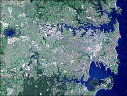
Sydney, New South Wales, Australia is located in a coastal basin bordered by the Pacific Ocean to the east, the Blue Mountains to the west, the Hawkesbury River to the north and the Woronora Plateau to the south. Sydney lies on a submergent coastline, where the ocean level has risen to flood deep river valleys (rias) carved in the sandstone. There are more than 70 harbour and ocean beaches, including the famous Bondi Beach, in the urban area.
Sydney's urban area covers 1,788 km² (690 mi²).[1] This area had 3,908,642 people , giving an urban population density of 2037 people per square kilometre. The Sydney Statistical Division, used for census data, is the unofficial metropolitan area[2] and covers 12,145 km² (4,689 mi²).[3] This area includes the Central Coast and Blue Mountains as well as broad swathes of national park and other non-urban land. At the 2011 census this area had 4,627,345 people.[4]
Geography
Sydney sprawls over two major regions: the Cumberland Plain, a relatively flat region lying to the south and west of Port Jackson, and the Hornsby Plateau, a sandstone plateau lying mainly to the north of the harbour, rising to 200 metres above sea level within the urban area and dissected by steep valleys such as the Lane Cove River valley. The city has fault lines which run considerably deep beneath the Sydney basin, dating back to when New Zealand started breaking away from Australia more than 85 million years ago.[5][6]
In 1820s, the plain west of Parramatta and Liverpool was described as "a fine timbered country, perfectly clear of bush, through which you might, generally speaking, drive a gig in all directions, without any impediment in the shape of rocks, scrubs, or close forest". This confirmed earlier accounts by Governor Phillip, who suggested that the trees were "growing at a distance of some twenty to forty feet from each other, and in general entirely free from brushwood..."[7]
The oldest parts of the city are located in the flat areas south of the harbour; the North Shore was slower to develop because of its hilly topography, and was mostly a quiet backwater until the Sydney Harbour Bridge was opened in 1932, linking it to the rest of the city, with the suburbs surrounding the northern entrance to said bridge effectively developing North Sydney into a second Central Business District.
Rivers
The Nepean River rises to the south in the Woronora Plateau, and wraps around the western edge of the city. Most of Sydney's water storages are on tributaries of the Nepean (e.g. the Warragamba River). Where the Nepean turns east it becomes the Hawkesbury River, which winds through the Hornsby Plateau before emptying into Broken Bay. Broken Bay and the lower Hawkesbury form the commonly accepted boundary between Sydney and the Central Coast to the north.
Parramatta River drains a large area of Sydney's western suburbs, flowing from west of Parramatta east, becoming a tidal estuary that flows into Port Jackson. Its banks have been largely industrial, but heavy industry is steadily moving away to be replaced by new housing developments and the Sydney Olympic Park. The other major tributaries flowing into Port Jackson are the Lane Cove River and Middle Harbour Creek.
The south and southwest of Sydney is drained by the Georges River, flowing from the south towards Liverpool and then turning south east towards Botany Bay. The other major tributary of Botany Bay is the Cooks River, running through the inner-south west suburbs. The Georges River estuary separates the main part of Sydney's urban area form Sutherland Shire. The Woronora River travels in a steep-sided valley from Woronora Dam to the Georges River.
Minor waterways draining Sydney's western suburbs include South Creek and Eastern Creek, flowing into the Hawkesbury, and Prospect Creek draining into the Georges River. Cowan Creek and Berowra Creek run north from the Upper North Shore to the Hawkesbury.
Climate
Sydney has a temperate climate with warm summers and mild winters. Rainfall is spread throughout the year.[8] The weather is moderated by proximity to the ocean, and more extreme temperatures are recorded in the inland western suburbs. The warmest month in the CBD is January, with an average air temperature range at Observatory Hill of 18.6–25.8 °C (65.5–78.4 °F). An average of 14.6 days a year have temperatures of more than 30 °C (86.0 °F). Winters are generally mild and temperatures rarely drop below 5 °C (41 °F) in coastal areas. The coldest month is July, with an average range of 8.0–16.2 °C (46.4–61.2 °F). Rainfall is fairly evenly spread through the year, but is slightly higher during the first half of the year, when easterly winds dominate.
Urban structure
The extensive area covered by urban Sydney is formally divided into more than 300 suburbs for addressing and postal purposes, and administered as 38 local government areas. There is no city-wide government, but the Government of New South Wales and its agencies have extensive responsibilities in providing metropolitan services.[9] The City of Sydney itself covers a fairly small area comprising the central business district and its neighbouring inner-city suburbs.
In addition, there are a number of informal regional names describing large sections of the urban area. Not all suburbs are necessarily covered by any of the following informal regional categories. The regions are Canterbury-Bankstown, the Eastern Suburbs, the Forest District, Greater Western Sydney, the Hills District, the Inner West, the Macarthur region, the Northern Beaches, the Northern Suburbs, the North Shore, Southern Sydney, South-western Sydney, the St George district, the Sutherland Shire and Western Sydney.
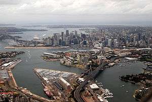
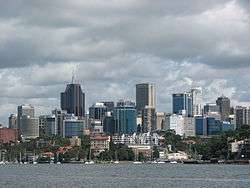
Sydney's central business district (CBD) extends southwards for about 2 kilometres (1.25 mi) from Sydney Cove, the point of the first European settlement. Densely concentrated skyscrapers and other buildings including historic sandstone buildings such as the Sydney Town Hall and Queen Victoria Building are interspersed by several parks such as Wynyard and Hyde Park.
The Sydney CBD is bounded on the east side by a chain of parkland that extends from Hyde Park through the Domain and Royal Botanic Gardens to Farm Cove on the harbour. The west side is bounded by Darling Harbour, a popular tourist and nightlife precinct while Central station marks the southern end of the CBD. George Street serves as the Sydney CBD's main north-south thoroughfare.
The oldest, inner suburbs are dominated by terrace housing. The original suburbs lay within walking distance of the CBD, and later urban development in the Inner West and Eastern Suburbs was served by trams. With a boom in passenger railway construction came rapid extension of the suburbs along the railway corridors to the west and south, and eventually to the North Shore, after the completion of the Harbour Bridge allowed trains to continue from North Sydney into the CBD. This radial-spoke pattern of development changed after World War II, when increasing car ownership encouraged infill development where the railways didn't run, and then further expansion around the perimeter of the city. These outer areas have mostly missed out on further rail expansion and are primarily car dependent to this day.
Although the CBD dominated the city's business and cultural life in the early days, other business/cultural districts have developed in a radial pattern since World War II. In 1945, two-thirds of all jobs in Sydney were located in the City of Sydney and surrounding inner city municipalities, but postwar suburbanisation meant that only a quarter of the workforce were located in the City, South Sydney, Leichhardt and Marrickville municipalities.[10] Together with the commercial district of North Sydney, joined to the CBD by the Harbour Bridge, the most significant outer business districts are Parramatta in the central-west, Blacktown in the west, Bondi Junction in the east, Liverpool in the southwest, Chatswood to the north, and Hurstville to the south.
Density
.jpg)
Sydney is particularly noted for its low population density. The reasons for Sydney's low-density development are rooted in its history. Surrounded by land that was considered unowned by the city's founders, early Sydney enjoyed relatively low land values, allowing more residents to acquire larger plots on which to live. This was reinforced by Sydney's development as a predominantly middle class, commercial city, in which even the working classes enjoyed higher wages and living standards than their counterparts in Europe.
Finally, Sydney acquired its public transport system early on in its life. Working-class suburbs could thus be built far from the city centre, whereas in older cities, the need to maintain walking distance between residential and employment centres kept sprawl to a minimum.[11]
Coupled with successive governments' willingness to release new land on the city's outskirts for further development, this history has given Sydney a low-density self-image. Ingrained hostility to urban consolidation and higher density living represents a major challenge to the city's future growth.
References
- ↑ Australian Bureau of Statistics (25 October 2007). "Community Profile Series : Sydney (Statistical Division)". 2006 Census of Population and Housing. Retrieved 2008-02-28.
- ↑ 1217.0.55.001 - Glossary of Statistical Geography Terminology, 2003, Australian Bureau of Statistics, 2003
- ↑ "2032.0 - Census of Population and Housing: Australia in Profile -- A Regional Analysis, 2001", Australian Bureau of Statistics, 2004-01-16
- ↑ "National Regional Profile: Sydney (Statistical Division)". ABS.gov.au. Retrieved 13 June 2015.
- ↑ "What lies beneath: going underground to report on Martin Place, Sydney". Costin Roe Consulting. 18 March 2016. Retrieved 28 May 2016.
- ↑ Smith, Deborah. "Revealed: Sydney's crack-up". The Sydney Morning Herald. Retrieved 12 August 2016.
- ↑ Kohen, J., The Impact of Fire: An Historical Perspective, in Australian Plants Online, Society for Growing Australian Plants, September 1996
- ↑ "Climate and the Sydney 2000 Olympic Games". Australian Government. Australian Bureau of Statistics. 24 September 2007. Archived from the original on 10 June 2008. Retrieved 21 December 2008.
- ↑ Department of Local Government. Local Council Boundaries Sydney Outer (SO)
- ↑ Spearitt, Peter, 2000, Sydney's Century: A History p. 122, Sydney: UNSW Press
- ↑ Forster, Clive 1996 Australian Cities: Continuity and Change. Oxford University Press