Darling Harbour

Darling Harbour is a harbour adjacent to the city centre of Sydney, New South Wales, Australia. It is also a large recreational and pedestrian precinct that is situated on western outskirts of the Sydney central business district. Originally Long Cove, the locality extends northwards from Chinatown, along both sides of Cockle Bay to Darling Harbour wharf on the east, and to the suburb of Pyrmont on the west. Cockle Bay is just one of the waterways that makes up Darling Harbour, which opens north into the much larger Port Jackson.
The precinct and its immediate surroundings are administered independently of the local government area of the City of Sydney, by a New South Wales state government statutory authority, the Sydney Harbour Foreshore Authority.
History
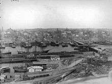
Darling Harbour is named after Lieutenant-General Ralph Darling, who was Governor of New South Wales from 1825 to 1831. The area was originally known as Long Cove, but was generally referred to as Cockle Bay until 1826 when Governor Darling renamed it after himself. The name Cockle Bay has recently been restored in reference to the headwaters of the harbour.[1] It was originally part of the commercial port of Sydney, including the Darling Harbour Railway Goods Yard. During the Great Depression, the eastern part of Darling Harbour (Barangaroo) became known as The Hungry Mile, a reference to the waterside workers searching for jobs along the wharves.[2]
Much of the land had been the site of the NSW Railways central marshalling yards and freight consolidation centre. The Enquiry into the NSW industry, including rail/road competition (1978–80), under Commissioner Gavan McDonell,[3] found that this centre was inefficient, should be moved, and the land used for other public purposes. These recommendations were acted upon and by the mid-to-late 1980s, when the area had become largely derelict it was redeveloped as a pedestrian and tourist precinct as an initiative of then New South Wales Minister for Public Works, Laurie Brereton. The Sydney Convention and Exhibition Centre at Darling Harbour was a venue of the 2000 Summer Olympic Games and a key meeting venue of APEC Australia 2007.
Attractions


The Darling Harbour precinct is home to a number of major public facilities and attractions, including:[4]
- Harbourside Shopping Centre, which includes Kingpin Bowling Alley (the only bowling alley in Darling Harbour), M9 Laser Skirmish, as well as Australia's first retail Jet flight simulator.
- Cockle Bay Wharf
- Sydney Entertainment Centre
- Paddy's Markets
- Chinese Garden of Friendship
- Tumbalong Park
- Darling Quarter Playground
- Sydney Convention and Exhibition Centre
- Australian National Maritime Museum (featuring museum ships including HMAS Vampire)
- SS South Steyne
- The Star Casino and Entertainment Complex
- The Darling Hotel & Spa
- Powerhouse Museum
- Sydney Aquarium
- Madame Tussauds
- Sydney Wildlife World
- Aboriginal Centre
- Sega World Sydney (closed in 2000)
- International Convention Centre Sydney (ICC Sydney), due to open in December 2016.[5]
Transport
Darling Harbour is accessible via various modes of public transport. The precinct is served by the Dulwich Hill Line of Sydney's light rail network, with access via Paddy's Markets, Convention, Exhibition and Pyrmont Bay stations.[6] Ferry wharves including Darling Harbour and Pyrmont Bay provide access to the Inner Harbour ferry services to Circular Quay and other suburbs. The Goods Line is a park and pedestrian pathway connecting Darling Harbour to Railway Square and Central Station. The nearest train station is Town Hall.
Redevelopment

East Darling Harbour is part of a massive urban renewal development. Plans for the 18-hectare (44-acre) site include half business and residential developments, while the other half to be reserved for open public space. The state government of NSW declared plans for "Globe Street", a street designed to become Australia's and Asia Pacific's centre for corporate trade (styled on New York's "Wall Street" district). The urban renewal development is not expected to be completed until 2020. East Darling Harbour will be known as Barangaroo.
The Sydney Convention and Exhibition Centre site is being replaced by the new International Convention Centre Sydney (ICC Sydney), scheduled for completion by December 2016. The new site will include a 40,000-square-metre (430,000 sq ft) exhibition facility, and is being developed by a consortium comprising AEG Ogden, Lend Lease, Capella Capital and Spotless Facilities Services, with AEG Ogden playing the role of venue operator.
This area was the site of the Sydney Port Authority and currently features an Overseas Passenger Terminal (Wharf 8) which is mainly used by the Pacific Dawn of the P&O Australia fleet and the Sun Princess, which is operated by Princess Cruises. It has previously been home port to the Pacific Sun, which is now based in Brisbane.
The area was temporarily used for several events during World Youth Day 2008, including the opening mass.
In popular culture
Darling Harbour is the location of the season residence on MTV's reality TV show, The Real World: Sydney, which aired in late 2007. The house has a large "Darling Harbour" sign along its edge, and the World Tower high rise building can be seen behind it.[7][8]
20th Century Fox's 1995 film Mighty Morphin Power Rangers: The Movie was shot in Sydney, and featured some scenes filmed in Darling Harbour.
Seven's Saturday morning TV Music Show Eclipse Music TV is filmed weekly at the precinct's shopping centre, Harbourside.
On 27 August 2010, the soap opera Neighbours filmed scenes in the harbour and on board the cruise ship, Pacific Jewel.[9]
Canadian post-hardcore band Silverstein recorded a song entitled "Darling Harbour" on their Transitions EP.
References
- ↑ Johnson, Wayne (2008). A history of Sydney's Darling Harbour. Sydney: Sydney Harbour Foreshore Authority. p. 7. ISBN 9780980545326.
- ↑ "Hungry Mile gets minor role". The Sydney Morning Herald. 12 September 2006.
- ↑ "Commission of Enquiry into the NSW transport industry, 6 vols, Sydney 1980". Opac.penrithcity.nsw.gov.au. Retrieved 9 February 2013.
- ↑ "Darling Harbour". Sydney.com. Retrieved 2 April 2013.
- ↑ http://insw.com/projects/darling-harbour-live-and-icc-sydney/timeline.aspx
- ↑ Transdev. Retrieved 4 October 2013
- ↑ Kaplan, Don. "Real World' Off to Sydney", The New York Post, 9 January 2007.
- ↑ Former OneWorld Sport Building, realworldhouses.com, 25 May 2010, accessed 14 February 2011
- ↑ "Neighbours become good Friends with Pacific Jewel". Travel Blackboard. 29 September 2010. Retrieved 13 March 2011.
External links[1]
| Wikivoyage has a travel guide for Sydney/Darling Harbour. |
- Darling Harbour
- Darling Hotel & Spa
- Kirsty Harris - University of Melbourne (2010). "Girard's wharf". Dictionary of Sydney. Retrieved 7 October 2015. [CC-By-SA]
Coordinates: 33°52′20″S 151°11′56″E / 33.87230°S 151.19896°E
- ↑ Johnson, Wayne (2008). A History of Sydney's Daring Harbour. Sydney: Sydney Harbour Foreshore Authority. ISBN 978-0-98054532-6.