Gaston, South Carolina
| Gaston, South Carolina | |
|---|---|
| Town | |
 Location of Gaston, South Carolina | |
| Coordinates: 33°48′57″N 81°6′3″W / 33.81583°N 81.10083°WCoordinates: 33°48′57″N 81°6′3″W / 33.81583°N 81.10083°W | |
| Country | United States |
| State | South Carolina |
| County | Lexington |
| Area | |
| • Total | 3.4 sq mi (8.9 km2) |
| • Land | 3.4 sq mi (8.9 km2) |
| • Water | 0.0 sq mi (0.0 km2) |
| Elevation | 499 ft (152 m) |
| Population (2010) | |
| • Total | 1,645 |
| Time zone | Eastern (EST) (UTC-5) |
| • Summer (DST) | EDT (UTC-4) |
| ZIP code | 29053 |
| Area code(s) | 803 |
| FIPS code | 45-28780[1] |
| GNIS feature ID | 1231307[2] |
| Website | www.gastonsc.org |
Gaston is a town in Lexington County, South Carolina, United States. The population was 1,645 at the 2010 census. It is part of the Columbia, South Carolina Metropolitan Statistical Area.
History
Gaston is named for the Gaston family.[3]
Demographics
| Historical population | |||
|---|---|---|---|
| Census | Pop. | %± | |
| 1980 | 960 | — | |
| 1990 | 984 | 2.5% | |
| 2000 | 1,304 | 32.5% | |
| 2010 | 1,645 | 26.2% | |
| Est. 2015 | 1,658 | [4] | 0.8% |
As of the census[1] of 2000, there were 1,304 people, 484 households, and 366 families residing in the town. The population density was 380.6 people per square mile (146.8/km²). There were 532 housing units at an average density of 155.3 per square mile (59.9/km²). The racial makeup of the town was 95.71% White, 1.07% African American, 0.84% Native American, 0.46% from other races, and 1.92% from two or more races. Hispanic or Latino of any race were 1.92% of the population.
There were 484 households out of which 40.9% had children under the age of 18 living with them, 60.1% were married couples living together, 10.7% had a female householder with no husband present, and 24.2% were non-families. 19.4% of all households were made up of individuals and 4.8% had someone living alone who was 65 years of age or older. The average household size was 2.69 and the average family size was 3.08.
In the town the population was spread out with 28.9% under the age of 18, 8.1% from 18 to 24, 31.9% from 25 to 44, 22.9% from 45 to 64, and 8.1% who were 65 years of age or older. The median age was 35 years. For every 100 females there were 97.0 males. For every 100 females age 18 and over, there were 96.0 males.
The median income for a household in the town was $31,411, and the median income for a family was $32,917. Males had a median income of $27,857 versus $21,680 for females. The per capita income for the town was $13,546. About 17.1% of families and 18.2% of the population were below the poverty line, including 26.1% of those under age 18 and 9.0% of those age 65 or over.
Geography
Gaston is located at 33°48′57″N 81°6′3″W / 33.81583°N 81.10083°W (33.815927, -81.100937),[6] on the banks of Bull Swamp Creek. According to the United States Census Bureau, the town has a total area of 3.4 square miles (8.8 km2), all of it land.
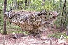
Gaston is home to Peachtree Rock-although it fell due to weather in 2013, located on the headwaters of Hunt Branch, right off of Highway 6 on Peachtree Rock Road. Hunt Branch feeds into Second Creek, which in turn flows into the Congaree River.
The Peachtree Rock Heritage Preserve, a Nature Conservancy property preserving 3,460 acres (1,400 ha) of land,[7] is home to several unique sandstone and ironstone formations.[8] These formations, resemble upside-down pyramids. Millions of years ago, this area—now known as the Sandhills—was the southeastern coastline of the continent. The park contains 7.5 miles (12.1 km) of hiking trails,.[9] It also contains the only coastal plain waterfall in South Carolina.[10]
The rock formations at Peachtree Rock Nature preserve are made from different types of rock. Sandstone, also known as arenite, makes up the softer, bottom layers of the formations while ironstone accounts for the harder and less-eroded top layers.
Town finances and services
Gaston relies mostly on business fees.[11]
In 2010, Gaston hired a police officer more than two years after dismantling its police department. Calhoun County Sheriff's Deputy Pat Regalis took over as police chief on August 2, 2010. Lexington County deputies will continue to patrol when Regalis is off. The town has set aside $96,000 to re-establish its police department, nearly one-quarter of the budget for the town. Mayor Troy Bivens hopes to add more officers as finances improve.
Education
Gaston area students go to schools in Lexington School District 4 and Lexington School District 2, Frances Mack Intermediate and Sandhills Middle are located in Gaston, while the Early Childhood Center, Sandhills Primary, Sandhills Elementary, Swansea High Freshmen Academy and Swansea High School are located in Neighboring Swansea, South Carolina. Parts of Gaston also attend Airport High School in West Columbia, Pine Ridge Middle School in Pine Ridge, RH Fulmer Middle School in West Columbia, and Congaree Elementary School in South Congaree.
References
- 1 2 "American FactFinder". United States Census Bureau. Retrieved 2008-01-31.
- ↑ "US Board on Geographic Names". United States Geological Survey. 2007-10-25. Retrieved 2008-01-31.
- ↑ Gannett, Henry (1905). The Origin of Certain Place Names in the United States. Govt. Print. Off. p. 135.
- ↑ "Annual Estimates of the Resident Population for Incorporated Places: April 1, 2010 to July 1, 2015". Retrieved July 2, 2016.
- ↑ "Census of Population and Housing". Census.gov. Retrieved June 4, 2015.
- ↑ "US Gazetteer files: 2010, 2000, and 1990". United States Census Bureau. 2011-02-12. Retrieved 2011-04-23.
- ↑ "South Carolina: Peachtree Rock Heritage Preserve". Nature Conservancy. Retrieved 2013-12-10.
- ↑ "Peachtree Rock Nature Preserve – Unfiltered". Random Connections. 2009-04-13. Retrieved 2013-12-10.
- ↑ Ginnie Saunders, Virginia Saunders, www.ginnie.com (2008-08-01). "Hiking Trail: Peachtree Rock Nature Preserve". SCTrails.net. Retrieved 2013-12-10.
- ↑ "Peachtree Rock Heritage Preserve". Nature.org. Retrieved 2013-12-10.
- ↑ "SC Town Hires 1-Man Police Department". WSAV. Associated Press. July 26, 2010. Archived from the original on 2011-07-18. Retrieved 2013-12-10.
External links
Municipalities and communities of Lexington County, South Carolina, United States | ||
|---|---|---|
| Cities | 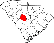 | |
| Towns | ||
| CDPs | ||
| Footnotes | ‡This populated place also has portions in an adjacent county or counties | |