Fulton-Commercial Streets District
|
Fulton-Commercial Streets District | |
|
Commercial Street view | |
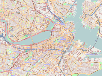   | |
| Location | Boston, Massachusetts |
|---|---|
| Coordinates | 42°21′43″N 71°3′12″W / 42.36194°N 71.05333°WCoordinates: 42°21′43″N 71°3′12″W / 42.36194°N 71.05333°W |
| Architect | Multiple |
| Architectural style | Renaissance |
| NRHP Reference # | [1] |
| Added to NRHP | March 21, 1973 |
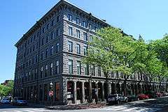
The Fulton-Commercial Streets District is a historic district encompassing a commercial area of the North End of Boston, Massachusetts. It is roughly bounded on the west by Cross Street, on the east by Lewis Street, on the north by Fulton Street, and on the south by Commercial and Mercantile Streets. It was developed during the second half of the 19th century on "made land" created by filling in the area just south of the Shawmut Peninsula as part of the Quincy Market development.[2]
The district was added to the National Register of Historic Places in 1973, and expanded slightly in 2000.[2]
See also
References
- ↑ National Park Service (2008-04-15). "National Register Information System". National Register of Historic Places. National Park Service.
- 1 2 "NRHP nomination for Fulton-Commercial Streets District (2000 increase)". Commonwealth of Massachusetts. Retrieved 2014-06-02.
| Topics |  | ||||||||||||||||||||||||||||||
|---|---|---|---|---|---|---|---|---|---|---|---|---|---|---|---|---|---|---|---|---|---|---|---|---|---|---|---|---|---|---|---|
| Lists by county | |||||||||||||||||||||||||||||||
| Lists by city |
| ||||||||||||||||||||||||||||||
| Other lists | |||||||||||||||||||||||||||||||
| |||||||||||||||||||||||||||||||
This article is issued from Wikipedia - version of the 11/26/2016. The text is available under the Creative Commons Attribution/Share Alike but additional terms may apply for the media files.