Franklin Township, Fulton County, Ohio
| Franklin Township, Fulton County, Ohio | |
|---|---|
| Township | |
|
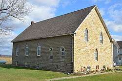
Former Ambrose Baptist Church on Road L | |
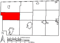 Location of Franklin Township in Fulton County | |
| Coordinates: 41°36′53″N 84°18′45″W / 41.61472°N 84.31250°WCoordinates: 41°36′53″N 84°18′45″W / 41.61472°N 84.31250°W | |
| Country | United States |
| State | Ohio |
| County | Fulton |
| Area | |
| • Total | 28.8 sq mi (74.6 km2) |
| • Land | 28.7 sq mi (74.5 km2) |
| • Water | 0.1 sq mi (0.2 km2) |
| Elevation[1] | 725 ft (221 m) |
| Population (2010) | |
| • Total | 743 |
| • Density | 25.7/sq mi (9.9/km2) |
| Time zone | Eastern (EST) (UTC-5) |
| • Summer (DST) | EDT (UTC-4) |
| FIPS code | 39-28294[2] |
| GNIS feature ID | 1086124[1] |
Franklin Township is one of the twelve townships of Fulton County, Ohio, United States. The 2010 census found 743 people in the township.[3]
Geography
Located in the western part of the county, it borders the following townships:
- Gorham Township - north
- Chesterfield Township - northeast corner
- Dover Township - east
- Clinton Township - southeast corner
- German Township - south
- Brady Township, Williams County - west
- Mill Creek Township, Williams County - northwest
No municipalities are located in Franklin Township.
Name and history
It is one of twenty-one Franklin Townships statewide.[4]
A couple miles north of the Ohio Turnpike, automobile drivers find an abrupt jog in Ohio State Route 66. Severe jogs are also in the township's other north-south roads, County Roads 19, 20, 21, 22, and 23. It happens where they intersect the "Old State Line," originally surveyed as the Ordinance line. Michigan once considered the northern part of Ohio, a difference of about 8 miles known as the Toledo Strip, as its own. Ohio and Michigan came to blows in an 1835-1836 military confrontation between the state militias known as the Toledo War. Fortunately, there were no casualties. To end the conflict, President Andrew Jackson gave Ohio the disputed territory, and gave Michigan the Upper Peninsula. The township's several misaligned roads are a constant reminder of northwest Ohio's unique history.[5][6]
Government
The township is governed by a three-member board of trustees, who are elected in November of odd-numbered years to a four-year term beginning on the following January 1. Two are elected in the year after the presidential election and one is elected in the year before it. There is also an elected township fiscal officer,[7] who serves a four-year term beginning on April 1 of the year after the election, which is held in November of the year before the presidential election. Vacancies in the fiscal officership or on the board of trustees are filled by the remaining trustees.
Attractions
The Tiffin River Wildlife Area offers hunting and bird watching in the flood plain of the Tiffin River. Harrison Lake State Park borders the north edge of the township at County Road M.
Public services
Public Schools
Students from the township are served by the following public local school districts:[8]
Mail is delivered in the township by the following U.S. Post Office locations:[9]
- Archbold, Ohio 43502
- Fayette, Ohio 43521
- Wauseon, Ohio 43567
- West Unity, Ohio 43570
Telephone
Most of the township lies within the Fayette telephone exchange, which is served by Frontier North, with telephone numbers using the following Numbering Plan Codes:[10]
- 419-237
- 419-500
- 567-404
A smaller eastern portion of the township is within the Wauseon telephone exchange, which is served by UTO (United Telephone Company of Ohio,) doing business as CenturyLink, with telephone numbers using the following Numbering Plan Codes:
- 419-330
- 419-335
- 419-337
- 419-388
- 419-404
- 419-583
- 419-590
Electric
Toledo Edison and Midwest Energy Cooperative serves the township with electricity.[11]
Highways
Ohio Turnpike Exit 25 intersects Ohio State Route 66 that runs through the township.
References
- 1 2 "US Board on Geographic Names". United States Geological Survey. 2007-10-25. Retrieved 2008-01-31.
- ↑ "American FactFinder". United States Census Bureau. Retrieved 2008-01-31.
- ↑ Fulton County 2014 Population Estimates For Cities, Villages, and Townships Ohio State University, published May 2015. Accessed 29 March 2016.
- ↑ "Detailed map of Ohio" (PDF). United States Census Bureau. 2000. Retrieved 2007-02-16.
- ↑ Ohio-Michigan Rivalry Began With A Border Dispute In 1835 themirrornewspaper.com Retrieved 29 March 2016
- ↑ Take Back the Toledo Strip! by David Swain, from the January 2014 issue, AnnArborObserver.com Retrieved 29 March 2016
- ↑ §503.24, §505.01, and §507.01 of the Ohio Revised Code. Accessed 4/30/2009.
- ↑ School District Boundary Maps GreatSchools.org. Retrieved 29 March 2016
- ↑ Zip Map: Fulton County ZipMap.net
- ↑ PUCO: Ohio Telephone Exchange Areas puco.gov
- ↑ PUCO: Electric Service Areas of Ohio puco.gov
External links
Municipalities and communities of Fulton County, Ohio, United States | ||
|---|---|---|
| City | 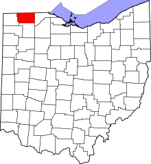 | |
| Villages | ||
| Townships | ||
| CDPs | ||
| Unincorporated communities | ||
| Ghost towns | ||
| Footnotes | ‡This populated place also has portions in an adjacent county or counties | |