Dover Township, Fulton County, Ohio
| Dover Township, Fulton County, Ohio | |
|---|---|
| Township | |
|
Wheat fields on Road L | |
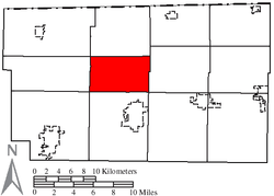 Location of Dover Township in Fulton County | |
| Coordinates: 41°36′44″N 84°11′16″W / 41.61222°N 84.18778°WCoordinates: 41°36′44″N 84°11′16″W / 41.61222°N 84.18778°W | |
| Country |
|
| State |
|
| County | Fulton |
| Government | |
| • Type | Township |
| • Trustee | Larry Burkholder |
| • Trustee | Kenneth Clark |
| • Trustee | Steve Gustwiller |
| • Fiscal Officer | Sue Dieringer |
| Area | |
| • Total | 21.5 sq mi (55.6 km2) |
| • Land | 21.5 sq mi (55.6 km2) |
| • Water | 0.0 sq mi (0.0 km2) |
| Elevation[1] | 761 ft (232 m) |
| Population (2010) | |
| • Total | 1,578 |
| • Density | 68.4/sq mi (26.4/km2) |
| Time zone | Eastern (EST) (UTC-5) |
| • Summer (DST) | EDT (UTC-4) |
| Area code(s) | 419 and 567 |
| FIPS code | 39-22442[2] |
| GNIS feature ID | 1086123[1] |
| Website | http://www.fultoncountyoh.com/index.aspx?NID=117 |


Dover Township is one of the twelve townships of Fulton County, Ohio, United States. The 2010 census found 1,578 people in the township, and estimated a population of 1,570 for 2014.[3]
Geography
Located in the central part of the county, it borders the following townships:
- Chesterfield Township - north
- Pike Township - east
- York Township - southeast corner
- Clinton Township - south
- German Township - southwest corner
- Franklin Township - west
- Gorham Township - northwest corner
It is one of only two townships in the county without a border on another county.
The following unincorporated communities are located in the township:
- Tedrow (a Census Designated Place (CPD))
- Ottokee
- Emery (extinct)
Dover Township is within the Toledo Metropolitan Area.[4]
Hydrology
Old Bean Creek, a tributary of Bean Creek, flows through the northwest corner of the township; a small portion of the township lies in its floodplain.[5]
There are no major bodies of water in the township; however, there is a wide variety of small ponds that dot the area.[6]
The northwestern portion of the township is drained by several small creeks that empty into Old Bean Creek, a tributary that empties into Bean Creek, also known as the Tiffin River. The southwestern part is drained by Brush Creek, which also empties into the Bean Creek/Tiffin River. The eastern portion of the township is drained by branches of Bad Creek. A small part of southern Dover Township south of Ottokee is drained by Turkeyfoot Creek. All of the water in Dover Township makes its way to the Maumee River which flows to Lake Erie.[7]
Name and history
Statewide, other Dover Townships within Ohio are located in Athens, Tuscarawas, and Union counties. Dover is a name often used in the New World, taken from the Old World location of Dover, England, a port in Kent, England, famous for its White Cliffs.
Prehistory
Lake Maumee
Dover Township's soils are sandy. It is because all of Dover Township, lies within Ohio's Lake Plains region,[8] which was once the bottom of an ancient lake known as Lake Maumee. As water levels rose and fell, sandy beach ridges and sand dunes formed along the shore. Contributing to the sandiness of the soils is the Defiance Moraine, an ancient glacial ridge that runs north-south through the middle of Fulton County. It was created late, perhaps during a short re-advancement of the glacier, before it began to melt and form Lake Maumee.[9]

While not as fertile as clay soils, the sand is well suited to fruits and vegetables, particularly potatoes, because they are easy to dig.[12] Potato farms are still found in the township.[13]
Oak Openings Prairie
Dover township, particularly the eastern portion, was oak savanna, known better in Ohio by the term Oak Openings. The oak trees were set apart sparsely enough that their tops usually did not touch. The Indians created this prairie of grass, interspersed with a few trees, as a hunting grounds through which they could move efficiently.[10][11]
Too, the early settlers could drive their wagons on the prairie through the open stand, in any direction among them.[14]
There are no significant remnant prairies left preserved in the township, save for frontier cemeteries such as Ottokee cemetery. These older cemeteries remain undisturbed from pioneering days, and support prairie foliage. Included are threatened or protected state species.[15]
Spring Hill
One the eastern part of the township is an area once known as Spring Hill. Brush Creek, which empties into the Tiffin River,[16] finds its source here, from a spring.
The spring's clean water made the spot a favorite Indian camp-ground and resting place in their migratory hunting excursions.[14]
Today, Spring Hill is known as Tedrow, named after a local family.[17]
Settlement
Tracts of northwest Ohio were made available for sale to the public as the Congress Lands. What was to become Dover Township laid partly in a survey titled North and East of the First Principal Meridian, and the northern part in what was still considered Michigan, known as the Toledo Strip.
The first settler into the township was William "Long Bill" Jones. He arrived with his family in 1836 and erected the first 14 foot by 16 foot cabin with the help of two Indians near Ottokee. For the first two years of settlement, pioneers stayed in the southwest portion of the township.[14]
Malaria
For a few years after 1838, from the beginning of summer until the first frost, over half the population of the township suffered from endemic malaria, generally known as "ague" at the time. The malaria caused fevers, chills. and the shakes. Doctors of the time reported that it took victims from three to five years to recover.[14] Residents of northwest Ohio in and close to the Great Black Swamp often used quinine, first isolated in 1820, to treat symptoms.[18]
First Election
Dover Township was officially organized by the Lucas County commissioners in Toledo on June 5, 1843. The first election on August 7, 1843 was held at the residence of Mortimer D. Hibbard.[19]
Dover was the last township organized in the county. It is also the smallest of the townships in Fulton county.[14] The United States General Land Office set a standard that townships were to be subdivided to cover 36 square miles, but Dover occupies only 21.5 square miles.
Toledo War

Many of the township's north-south roads "jog" where they intersect the east-west "Old State Line Road," now designated County Road K.[20] The reason is an old survey line known as the Ordinance line; Michigan considered the northern part of Ohio, a difference of about 8 miles known as the Toledo Strip, as its own. Ohio and Michigan came to blows in a 1835-1836 military confrontation between the state militias known as the Toledo War. Fortunately, there were no casualties. To end the conflict, President Andrew Jackson gave Ohio the disputed territory, and gave Michigan the Upper Peninsula. The township's misaligned intersections along County Road K, including a slight jog in Ohio State Route 108, are a constant reminder of Ohio's longstanding rivalry with neighboring Michigan.[21][22]
"Centre" of the County
Ottokee is the small town in the southeastern region of the township. It rose from settlement being first to come to the area. It is situated in the center of the county; hence, it was once called "Centre."[23]
Seat of Justice
Ottokee served as the county seat for 21 years. The railroads in Wauseon brought greater economic success to Wauseon, and the county's justice system moved there.[14] The county's nursing home was located there until 1975. The airport and maintenance facilities for the County engineer are also located there.[24]

Today, the Ohio State Extension office,[25] the United States Department of Agriculture Farm Service Agency Center,[26] and the Fulton County Soil and Water Conservation District office are all located across the road from the Fulton County Fair.[27]
A new historical museum/welcome center for the county, one that will replicate the architecture of the first wooden courthouse in Ottokee, is now being built across from the county fairgrounds.[28]
Railroad Station
Although too late to preserve Ottokee as the seat of justice, a railroad did finally pass through. In 1895, the Lima Northern Railway Company was organized in Ohio. The LN built north from Lima through Napoleon and Wauseon, with a stop in Ottokee at the county fairgrounds, then onto Oak Shade and Adrian, Michigan. In 1897, the railway changed to Detroit and Lima Northern Railway Company (D&LN),[29] which subsequently became the Detroit, Toledo, and Ironton Railroad in 1905.[30]
After World War I, Henry Ford bought the DT&I railroad, and in 1925, built a new, faster track east of Ottokee, that passed through Delta, Ohio.[30] This relegated the DT&I railway serving Ottokee to a mere spur, known as the "Tecumseh Branch," because it terminated in Tecumseh, Michigan.[31] It was slowly abandoned in the late 1950s. An 8-mile stretch from Adrian to Tecumseh has been converted to a rail to trail called the Kiwanis Trail.[32]
The old railway right-of-way paralleled Ohio State Route 108, just west of the highway.[33] The Ohio Turnpike built a bridge over the railroad in 1954, which still stands today.[34]

Fulton County Fair
The Fulton County Fair is located in Dover Township. It was started in 1858. Another agricultural society in Dover Township was also started, in 1874 in Ottokee, Grange No. 273, one of several Grange organizations in Fulton County.[17] However, the Grange movement finally withered with farms becoming fewer with mechanization. But the Fulton County Fair, still very much an agricultural fair, has become quite large. For a few busy days during Labor Day weekend, Dover Township hosts a temporary "city" of up to 60,792, some 50% larger than Fulton County's census of 42,698.[35][36]
The fairgrounds is the site of the Fulton County 9/11 Memorial. Ottokee also features another historical monument, one dedicated to women in wartime.
Government
The township is governed by a three-member board of trustees, who are elected in November of odd-numbered years to a four-year term beginning on the following January 1. Two are elected in the year after the presidential election and one is elected in the year before it. There is also an elected township fiscal officer,[37] who serves a four-year term beginning on April 1 of the year after the election, which is held in November of the year before the presidential election. Vacancies in the fiscal officership or on the board of trustees are filled by the remaining trustees. Officials are as follows, namely:
| • Trustee: | Larry Burkholder |
| • Trustee: | Kenneth Clark |
| • Trustee: | Steve Gustwiller |
| • Fiscal Officer: | Sue Dieringer |
Public services
Public Schools
Six school houses once dotted the township.[14]
Today, student are educated outside the township by the following public local school districts:[39]
Historically, there have been three post offices within the township, namely, Ottokee, Tedrow, and Emery.[14][40][41]
Today, the vast majority of the township is covered by ZIP code 43567, with mail delivered from the U.S. Post Office in Wauseon, Ohio. A few residences in a small northwest portion of the township are served by the Post Office in Fayette, Ohio, whose ZIP code is 43521.[42]
Telephone
The first telephone in Fulton County was the Northwest Telephone Company in Wauseon. The line ran to Ottokee in 1897 as a "toll" line. The next year, the party line system was implemented.[17][43]
The entire township today is still within the Wauseon telephone exchange, which is served by UTO (United Telephone Company of Ohio,) doing business as CenturyLink, with telephone numbers using the following Numbering Plan Codes:[44]
- 419-330
- 419-335
- 419-337
- 419-388
- 419-404
- 419-583
- 419-590
Electric
Toledo Edison serves the majority of the township from Ohio State Route 108 to the west. Midwest Energy Cooperative serves a smaller eastern area.[45]
Water
Most residents in rural Dover Township rely on wells or ponds for water. Most of the township gets its water from the Oak Openings Beach Ridge Aquifer. Eastern portions closer to the Tiffin River draw from the Lake Maumee Lacustrine Aquifer. A small northern portion of higher elevations in the north are Williams End Moraine Aquifer.[46]
City water from Wauseon, stored in a new water 100,000 gallon tower built in 2003 on the county fairgrounds, serves the "Tedrow/Ottokee Waterline."[47] An aerator was installed in 2015 to disperse trihalomethane,[48] a common, but undesirable, by-product of water chlorination.[49] Water processed by the City of Wauseon comes from as far away as the Maumee River.[50]

Highways
| |
|
|---|---|
| | |
| | |
The Ohio Turnpike was opened in western Ohio in the fall of 1955.[51] Coincidentally, it fits neatly within the alphabetical organization of the east-west county roads, with County Road H paralleling to the south of the I-80/90 route, and County Road J to the north.[52]
Exit 34, connecting the Turnpike to Ohio State Route 108, is in the township, beside the fairgrounds. The tollbooths have been upgraded to automated toll collection with E-ZPass and fare machines.[53]
Ohio State Route 108 is busy, with 4930 vehicles passing per day. County Road 14, between Ottokee and Wauseon also sees high traffic, at 3444 vehicles per day.[54]
Airport
One the eastern edge of the township is Fulton County Airport, designated as KUSE. St. Vincent Mercy Medical Center's Aérospatiale SA 365 Dauphin Life Flight 2 helicopter is hangared here to perform medical evacuation.[55]
Fire and Emergency Medical Services
Dover Township contracts with the Wauseon Fire Department and Fulton County's Emergency Medical Services (EMS) Department located in Wauseon, Ohio.[56][57] Fulton County Health Center in Wauseon offers the closest Emergency Department that is 4.8 miles, and approximately 9 minutes, from the fairgrounds within the township.[58]
Tornado Sirens
Tornado sirens, used to alert people outside that something dangerous is approaching,[59] serve much of the township. They are located at Tedrow in the southwestern part of the township, at the Fulton County Fairgrounds in the southeastern part, and in Advance, at the northeast corner of the township.[60]
NOAA Weather Radio
Dover Township is within the purview of IWX, the National Weather Service (NWS) Forecast Office for Northern Indiana.[61] NOAA Weather Radio (NWR) stations that cover the township include the following stations:[62]
| Station | Call Sign | Frequency (MHz) |
Power (Watts) |
SAME# | Weather Forecasting Office (WFO) |
|---|---|---|---|---|---|
| Angola, IN[63] | KXI94 | 162.425 | 1000 | 039051 | IWX (North Webster, IN)[61] |
| Adrian, MI[64] | WNG647 | 162.450 | 300 | 039051 | DTX (White Lake, MI)[65] |
| Toledo, OH[66] | WXL51 | 162.500 | 300 | 039051 | CLE (Cleveland, OH)[67] |
References
- 1 2 "US Board on Geographic Names". United States Geological Survey. 2007-10-25. Retrieved 2008-01-31.
- ↑ "American FactFinder". United States Census Bureau. Retrieved 2008-01-31.
- ↑ Fulton County 2014 Population Estimates For Cities, Villages, and Townships Ohio State University, published May 2015. Accessed 29 March 2016.
- ↑ "Toledo Metropolitan Statistical Area Data". Fulton County Economic Development Corporation (FCEDC). Retrieved 9 April 2016.
- ↑ Fulton County Floodplains with Aerials and Hillshade (Map). Fulton County, Ohio. Retrieved 9 April 2016.
- ↑ Fulton County Reservoirs, Ponds, and Creeks (Map). Fulton County, Ohio. Retrieved 9 April 2016.
- ↑ Fulton County Watersheds from USGS (Map). Fulton County, Ohio. Retrieved 10 April 2016.
- ↑ "Ohio Natural Regions". Retrieved 4 April 2016.
- ↑ Blockland, Joseph D. (2013). The Surficial Geology of Fulton County, Ohio: Insight into the Late Pleistocene-Early Holocene Glaciated Landscape of the Huron-Erie Lake Plain, Fulton County Ohio, USA. University of Toledo. Retrieved 5 April 2016.
- 1 2 Oak Openings MetroParksToledo.com
- 1 2 Goll Woods Walking Guide OhioDNR.gov. Retrieved 29 March 2016
- ↑ "Annual Report of the Ohio State Board of Agriculture, Volume 36, Part 1881". Retrieved 4 April 2016.
- ↑ Mrs. Dennis Potato Farm
- 1 2 3 4 5 6 7 8 Aldrich, Lewis Cass (1888). History of Henry and Fulton counties, Ohio : with illustrations and biographical sketches of some of its prominent men and pioneers. Syracuse, N. Y.: D. Mason & Co., Publishers. pp. 465–475.
- ↑ Federal Energy Regulatory Commission. "Chapter 2: Natural Resources - Unique Habitats - Remnant Prairies". p. 6. Retrieved 10 April 2016.
- ↑ DeLorme. Ohio Atlas & Gazetteer. 7th ed. Yarmouth: DeLorme, 2004, pp. 25, 35. ISBN 0-89933-281-1.
- 1 2 3 Reighard, Frank (1920). A Standard History of Fulton County, Ohio. Lewis Publishing Company. pp. 344–370. Retrieved 5 April 2016.
- ↑ "Historic Perrysburg: Great Black Swamp". Retrieved 6 April 2016.
- ↑ History of Dover Township, OH The History of Fulton County, Ohio, Northwestern Historical Association, 1905, Thomas Mikesell, Editor, rays-place.com Retrieved 29 March 2016
- ↑ "Rural County Maps: Fulton County" (PDF). Ohio Department of Transportation. Retrieved 9 April 2016.
- ↑ Ohio-Michigan Rivalry Began With A Border Dispute In 1835 themirrornewspaper.com Retrieved 29 March 2016
- ↑ Take Back the Toledo Strip! by David Swain, from the January 2014 issue, AnnArborObserver.com Retrieved 29 March 2016
- ↑ Guilford, Russell (1976). Official Souvenir Booklet in Celebration of 200 Years of National Freedom, 1776-1976 Emphasizing Fulton County, Ohio.
- ↑ Fulton County Engineer, 9120 Co. Rd. 14
- ↑ OSU Extension | Fulton County, 8770 State Route 108
- ↑ Farm Service Agency, 8770 STATE ROUTE 108
- ↑ Soil and Water Conservation District, Fulton County
- ↑ Romaker, Janet (22 September 2014). "FULTON COUNTY PRESERVES PAST, BUILDS OFF IT:Courthouse restoration, new building provide homage to regional history". Toledo Blade. Retrieved 11 April 2016.
- ↑ Ohio Commissioner of Railroads and Telegraphs (1898). Annual Report of the Commissioner of Railroads and Telegraphs, to the Governor of the State of Ohio, for the Year 1897, Volume 30. Norwalk, Ohio: L.D. Myers & Bro., State Printers.
- 1 2 Pletz, William C. (1979). The Railroad That Went No Place (but eventually made it). Ann Arbor Train and Trolley Watchers.
- ↑ "Timetable: DT&I Tecumseh Branch - Malinta to Tecumseh". Michigan's Internet Railroad History Museum. Retrieved 7 April 2016.
- ↑ "Traillink: Kiwanis Trail, MI". Retrieved 4 April 2016.
- ↑ "DT&I". Retrieved 5 April 2016.
- ↑ "I80 TPK over DT&I RR MP0405 L, Structure #2629674". Ugly Bridges. Retrieved 7 April 2016.
- ↑ Fulton County Fair Aims to Draw 300,000 ToledoBlade.com. Retrieved 28 March 2016.
- ↑ 250,000 Expected to Attend Fulton County Fair ToledoBlade.com. Retrieved 28 March 2016
- ↑ §503.24, §505.01, and §507.01 of the Ohio Revised Code. Accessed 4/30/2009.
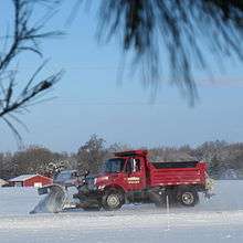
- ↑ "WHITE SPRING: Nearly 8 inches of snow covers Toledo, Sheriff's offices declare emergencies; hundreds without power". Toledo Blade. Retrieved 9 April 2016.
- ↑ School District Boundary Maps GreatSchools.org. Retrieved 29 March 2016
- ↑ "Ghost Towns of Fulton County". ForgottenOhio. Retrieved 5 April 2016.
- ↑ "Ghost Towns of Fulton County". Ancestry.com. Retrieved 5 April 2016.
- ↑ Zip Map: Fulton County ZipMap.net
- ↑ Development of the Telephone Field: Valuation of Ohio Telephone Companies. Western Electrician, Volume 27. October 27, 1900. Retrieved 5 April 2016.
- ↑ PUCO: Ohio Telephone Exchange Areas puco.gov
- ↑ PUCO: Electric Service Areas of Ohio puco.gov
- ↑ Fulton County Aquifers (Map). FultonCountyOH.com. Retrieved 10 April 2016.
- ↑ "Fulton County Commissioners, Minutes of February 27th, 2003". Retrieved 9 April 2016.
- ↑ "FC commissioners approve emergency aerator, July 7th, 2015". Retrieved 9 April 2016.
- ↑ "Health Risk of the Trihalomethanes Found in Drinking Water". United States Environmental Protection Agency. Retrieved 9 April 2016.
- ↑ Water Plant - City of Wauseon Retrieved 9 April 2016
- ↑ Staff. "Chapter 3: Giant Strides, 1946–1964". The First 60 Years, A History of Service. Ohio State Highway Patrol. Archived from the original on March 2, 2008. Retrieved 5 April 2016.
- ↑ OpenStreetMap contributors. Node: Ottokee (154369908) (Map). OpenStreetMap. Retrieved 5 April 2016.
- ↑ "Machines to replace toll-takers at 4 booths". Toledo Blade. Retrieved 9 April 2016.
- ↑ 2007 Traffic Count Map (Map). Fulton County, Ohio. Retrieved 9 April 2016.
- ↑ LifeFlight 2 lifeflight.cc Retrieved 29 March 2016
- ↑ Fulton County Fire Districts (Map). Fulton County, Ohio. Retrieved 9 April 2016.
- ↑ Wauseon Fire Department
- ↑ Google Maps google.com Accessed 1 April 2016
- ↑ "Siren FAQ". National Weather Service (NWS). Retrieved 9 April 2016.
- ↑ FC-GIS, L. Sackmann, 2011. Tornado Siren Locations in Fulton County (Map). Fulton County, Ohio. Retrieved 9 April 2016.
- 1 2 IWX: NWS Forecast Office for Northern Indiana
- ↑ "NWR County Coverage Listing for Ohio". National Weather Service (NWS). Retrieved 9 April 2016.
- ↑ "NOAA Weather Radio All Hazards County Coverage for KXI94". National Weather Service. Retrieved 9 April 2016.
- ↑ "NOAA Weather Radio All Hazards County Coverage for WNG647". National Weather Service. Retrieved 9 April 2016.
- ↑ DTX: NWS Forecast Office for Detroit/Pontiac, MI
- ↑ "NOAA Weather Radio All Hazards County Coverage for WXL51". National Weather Service. Retrieved 9 April 2016.
- ↑ CLE: NWS Forecast Office for Cleveland, OH
External links
Municipalities and communities of Fulton County, Ohio, United States | ||
|---|---|---|
| City | 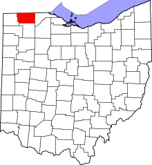 | |
| Villages | ||
| Townships | ||
| CDPs | ||
| Unincorporated communities | ||
| Ghost towns | ||
| Footnotes | ‡This populated place also has portions in an adjacent county or counties | |