Franklin Common Historic District
|
Franklin Common Historic District | |
|
Franklin Federated Church | |
  | |
| Location | Franklin, Massachusetts |
|---|---|
| Coordinates | 42°5′19″N 71°24′5″W / 42.08861°N 71.40139°WCoordinates: 42°5′19″N 71°24′5″W / 42.08861°N 71.40139°W |
| Area | 35 acres (14 ha) |
| Built | 1787 |
| Architect | Paine, Walter J.,; Sullivan, Matthew |
| Architectural style | Federal, Greek Revival |
| NRHP Reference # | [1] |
| Added to NRHP | March 31, 2005 |
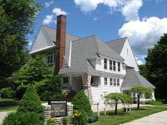
The Franklin Common Historic District is a historic district encompassing the traditional village center of Franklin, Massachusetts. The primary focus of the district is the town common, a roughly triangular green which took shape in the mid-18th century. The district includes the buildings that abut the green, and extends northward along Main Street to its junction with Lincoln Street, where the Red Brick School is located. The Dean Junior College Historic District abuts this district to the south. The district is predominantly residential in character, with several civic and religious institutional buildings facing the common. The latter group are dominated by the Federated Church (Shingle style, built 1895), and the Roman Catholic St. Mary's Church complex, which includes three buildings from the 1920s to 1955.[2]
The district was listed on the National Register of Historic Places in 2005.[1]
See also
References
- 1 2 National Park Service (2008-04-15). "National Register Information System". National Register of Historic Places. National Park Service.
- ↑ "NRHP nomination for Franklin Common Historic District". Commonwealth of Massachusetts. Retrieved 2014-09-02.
| Topics |  | ||||||||||||||||||||||||||||||
|---|---|---|---|---|---|---|---|---|---|---|---|---|---|---|---|---|---|---|---|---|---|---|---|---|---|---|---|---|---|---|---|
| Lists by county | |||||||||||||||||||||||||||||||
| Lists by city |
| ||||||||||||||||||||||||||||||
| Other lists | |||||||||||||||||||||||||||||||
| |||||||||||||||||||||||||||||||