Four Marks
| Four Marks | |
 Medstead & Four Marks Station |
|
 Four Marks |
|
| Population | 4,799 |
|---|---|
| OS grid reference | SU669351 |
| Civil parish | Four Marks |
| District | East Hampshire |
| Shire county | Hampshire |
| Region | South East |
| Country | England |
| Sovereign state | United Kingdom |
| Post town | ALTON |
| Postcode district | GU34 |
| Dialling code | 01420 |
| Police | Hampshire |
| Fire | Hampshire |
| Ambulance | South Central |
| EU Parliament | South East England |
| UK Parliament | East Hampshire |
Coordinates: 51°06′42″N 1°02′40″W / 51.11155°N 1.04434°W
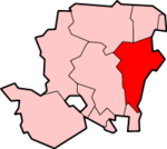
Four Marks is a village and civil parish in the East Hampshire district of Hampshire, England. It is 4.4 miles (7.1 km) southwest of Alton, on the A31 road. It is situated on the borders of the South Downs National Park on the Pilgrims' Way [1] that leads from Winchester to Canterbury. Just northeast of the village, on the edge of Chawton Park Wood, is one of Hampshire's highest points, Red Hill at 211 metres (692 ft).
History
Four Marks was originally settled by veterans of the Crimean War, who were allocated plots for their smallholdings, and was the site of a telegraph.
According to Bartholomew’s Gazetteer, the village of Four Marks is the only so named place in the United Kingdom.
The first mention of it appears in a document c.1550, albeit spelt differently. The heading of the page can be translated as ‘Perambulation of the Manor of Alresford’ and consists of a description of the boundaries. The reference to Four Marks translates roughly as “a certain vacant piece of land called Fowrem’kes near Bookmere and so called Fowrem’kes because iiii adjoining tithings abut there namely the tithings of Medsted Ropley Faryngdon & Chawton”. There were thus borders extending in four directions, called a quadripoint.
The area was well known as Four Marks and even had its own post office and facility for cancelling stamps. The first mention of the post office is a record in the proof books of the General Post Office of the issue of a rubber datestamp on 25 March 1897.[2] (The post office closed in early 2007). Four Marks did not become a parish until 1932 when seven parishes were annexed to create it. It included parts of the above-mentioned parishes i.e. Medstead, Ropley, Farringdon and Chawton, Kitwood note changed spellings, plus East Tisted and Newton Valence.[3]
Local amenities
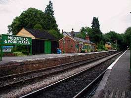
The village has its own restored railway station on the Watercress Line, services from which connect with the nearest national rail station 4.4 miles (7.1 km) to the northeast, at Alton.
The village has a large recreation ground including football, cricket, tennis courts, local bowls club and BMX ramps. The village Centre has been recently refurbished, and includes a restful area surrounded by flowerbeds under the village clock. The local amenities include a bakers, a fish and chip shop, an off licence, a fine wine shop, a hairdressers, a bicycle shop, and good free parking. The Primary School (Four Marks Primary School), is a Church of England school bearing the highest possible rank of "Outstanding" by OFSTED.[4] The village has a historic railway station forming part of the Watercress Line.
Four Marks is situated in some of the finest unspoilt Hampshire countryside. It is about half way along the historic St. Swithun's Way passing through the south-western fringe of the village, which links the South Downs Way at Winchester, the capital of Saxon England; to the North Downs Way at Farnham.
Local interest
Steam Locomotives, restored and operated by The Watercress Line, run regular services between Alton and Alresford (Hampshire), stopping at Medstead and Four Marks railway station.
Four Marks is host to a small brewery Triple fff Brewery whose beer can be found in several pubs in the region.
Media
The local newspapers are the Alton Herald and the Hampshire Chronicle. Both are published weekly. The Alton Herald regularly features articles about Four Marks.
The village also has a thriving volunteer-produced monthly magazine, the Four Marks News, which costs 50p and is also supported by classified advertising.
The Breeze (radio network) is the local Radio station on 101.6FM with a transmitter based in Four Marks, the service is relayed from the Southampton area.
BBC South is the local BBC service and ITV Meridian is the local ITV service. The BBC Local Radio service for the area is BBC Solent. All services are broadcasting from the Southampton area.
External links
| Wikimedia Commons has media related to Four Marks. |
- Google Maps Aerial Photograph
- Four Marks information and pictures
- Four Marks Primary School
- Local Radio
- Alton Herald
- Local Brewery
 |
Bighton | Medstead | Alton | |
| Soldridge New Alresford |
|
Lower Farringdon | ||
| ||||
| | ||||
| Ropley | West Tisted | East Tisted |
References
- ↑ "Pilgrim's Way".
- ↑ James Alexander Mackay (1986). Sub Office Rubber Datestamps of England and Wales. ISBN 978-0-906440-39-1.
- ↑ Four Marks: Its Life and Origins, by Betty Mills, 1995, ISBN 978-0-9526603-0-9
- ↑ Ofsted | Four Marks Church of England Primary School