Binsted
| Binsted | |
 Telegraph House, Binsted. |
|
 Binsted |
|
| Population | 1,635 (2001) |
|---|---|
| OS grid reference | SU770411 |
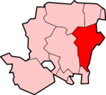
| Civil parish | Binsted |
| District | East Hampshire |
| Shire county | Hampshire |
| Region | South East |
| Country | England |
| Sovereign state | United Kingdom |
| Post town | ALTON |
| Postcode district | GU34 4 |
| Police | Hampshire |
| Fire | Hampshire |
| Ambulance | South Central |
| EU Parliament | South East England |
Coordinates: 51°09′51″N 0°53′55″W / 51.16405°N 0.89866°W
Binsted is a village and civil parish in the East Hampshire district of Hampshire, England. It lies about 4.1 miles (6.6 km) east of Alton, its nearest town. The parish covers an area of 1,206 acres (488 ha), and contains two hamlets, Wyck and Wheatley. The nearest railway station is 1.8 miles (2.9 km) northeast of the village, at Bentley. According to the 2011 census, the parish had a population of 1596 people.
The village was first mentioned at the time of the Domesday Survey in 1086, and later records show that quarries was dug up in the area. The history of Binsted from the 11th to 19th centuries were not documented, owing to its isolation and non-involvement in controversial activity. The parish has 58 Grade II listed buildings, and one Grade I building – the Church of the Holy Cross.
History
At the time of the Domesday Survey of 1086, the manor of Binsted was held by Tovi, the king's thegn, as a free manor. Later records showed that Binsted was passed to the crown shortly afterwards.[1] At the time of the Domesday Survey the village name at the time was "Benested", which means "holding of the land".[2] Over the years there have been different variations on the spelling of the name; including Bensted, Benested and Boonsted (11th century), Bensted (14th century), and Bennsted (17th century).[1][2] Before the Norman Conquest, the village was known as "Binsted Popham" and was held by the King of Wessex.[2] William the Conqueror granted the manor of Binsted to the Bishop of Winchester, and allowed digging for stone around the village in what later developed as quarries.[1] Henry I fell into dispute with the then Bishop of Winchester and the monks of St Swithun's over Binsted, but he eventually allowed the monks to continue quarrying.[1]
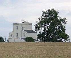
The history of Binsted from the 11th century to the early 19th century is not documented,[1] with some sources maintaining that the village remained a "simple agricultural community" and was not involved in any controversial activity.[2] Telegraph House, now a private home, was built by the Admiralty in 1825 as a semaphore relay station on the railway line linking London with Plymouth, with the intention to provide a number of key relay stations forming a line of communication between important points.[3][4] Binsted School was built in 1875.[2]
In 1870–72 the Imperial Gazetteer of England and Wales by John Marius Wilson described Binsted as:
... a parish and a subdistrict in the district of Alton, Hants. The parish lies 2½ miles SSW of Bentley r. station, and 4 NE by E of Alton; contains the hamlets of Issington, Week, Westcote, and Wheatley; and has a post office under Alton. Acres, 6,833. Real property, £7,104. Pop., 1,195. Houses, 231. Binstead Hill is the seat of the Coulthards. The living is a vicarage, united with the vicarage of Kingsley, in the diocese of Winchester. Value, not reported.* Patrons, the Dean and Chapter of Winchester. The church is ancient, has a low embattled tower and a spire, and contains several monuments. There is a Primitive Methodist chapel.-The subdistrict comprises eight parishes and an extra-parochial tract. Acres, 27,482. Pop., 4,806. Houses, 980.[5]
Geography and demographics
Binsted is located in the eastern central part of Hampshire, in South East England, 4.1 miles (6.6 km) east of Alton, its nearest town.[6] The parish covers an area of 1,206 acres (488 ha), of which 299 acres (121 ha) are of arable land, 476 acres (193 ha) of permanent grass, and 253 acres (102 ha) of woodland.[1] The landscape is dominated by farms and woodland such as Binsted Farm, Wheatley Copse and Sparkfield Wood.[6] A number of old quarries indicate that chalk was once worked in the parish.[1] The parish contains two individual hamlets; Wyck and Wheatley.[6] According to the 2011 census, the parish of Binsted had a population of 1596 people. In addition, there are 711 households in the parish with an average size of 2.56 people.[7]
 |
Upper Froyle | Bentley | Bucks Horn Oak | |
| Alton | |
Blacknest | ||
| ||||
| | ||||
| East Worldham | Kingsley | Bordon |
Notable landmarks

The parish contains a total of 58 Grade II listed buildings,[8] including a Grade II* listed barn,[9] and the Church of the Holy Cross, a Grade I listed building.[10] The church dates from the late 12th century with early 13th and 15th century additions, as well as a substantial restoration in 1863. The building itself consists of stone walls, a tiled roof, and a stone slated porch. The oldest part is the chancel, which dates from the 12th century with 15th century extensions. The north chapel was altered and extended by the action of Richard de la Bere in 1331.[10] Other listed buildings include Barnfield House – three houses which were once separated all dating from 1550 with 20th century restorations. The house itself has a timber frame with a tiled roof, including a late medieval hall.[11] Mill Court, another Grade II listed building, is a large dating from the early 19th century with a low pitched roof and yellow brickwork. It became a listed building on 15 August 1985.[12]
External links
| Wikimedia Commons has media related to Binsted, Hampshire. |
- The History of the Church of the Holy Cross, Binsted
- Church of the Holy Cross, Binsted
- Stained Glass Windows at Holy Cross, Binsted, Hampshire
References
- 1 2 3 4 5 6 7 Page, William (1912). "History of Binsted". British History Online. pp. 151–155. Retrieved 4 October 2016.
- 1 2 3 4 5 "The History of Binsted Village". Bentley Parish Council. Archived from the original on 7 July 2011. Retrieved 4 October 2016.
- ↑ "Telegraph House". Bentley Parish Council. Archived from the original on 7 July 2016. Retrieved 4 October 2016.
- ↑ "Binsted Village as it is today". Bentley Parish Council. Archived from the original on 7 July 2016. Retrieved 4 October 2016.
- ↑ "History of Binsted in East Hampshire". A Vision of Britain Through Time. University of Portsmouth. Retrieved 4 October 2016.
- 1 2 3 Maps (Map). Google Maps.
- ↑ "Population of Binsted". Hampshire Hub. Retrieved 4 October 2016.
- ↑ "Listed Buildings in Binsted". British Listed Buildings. Retrieved 4 October 2016.
- ↑ "Barn 30 Metres North of West Court - Binsted". British Listed Buildings. Retrieved 4 October 2016.
- 1 2 "Church of the Holy Cross - Binsted". British Listed Buildings. Retrieved 4 October 2016.
- ↑ "Barnfield House - Binsted". British Listed Buildings. Retrieved 4 October 2016.
- ↑ "Mill Court - Binsted". British Listed Buildings. Retrieved 4 October 2016.