Erb's Covered Bridge
| Erb's Covered Bridge | |
|---|---|
 | |
| Coordinates | 40°10′04″N 76°14′38″W / 40.16778°N 76.24389°WCoordinates: 40°10′04″N 76°14′38″W / 40.16778°N 76.24389°W |
| Locale | Lancaster County, Pennsylvania, United States |
| Official name | Hammer Creek #1 Bridge |
| Characteristics | |
| Design | single span, double Burr arch truss |
| Total length | 80 feet (24.4 m) |
| History | |
| Constructed by | Unknown |
| Construction begin | 1849 |
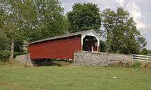
The Erb's Covered Bridge is a covered bridge that spans Hammer Creek in Lancaster County, Pennsylvania, United States.[1] A county-owned and maintained bridge, its official designation is the Hammer Creek #1 Bridge.[2]
The bridge has a single span, wooden, double Burr arch trusses design with the addition of steel hanger rods. The deck is made from oak planks.[2] It is painted red, the traditional color of Lancaster County covered bridges, on both the inside and outside. Both approaches to the bridge are painted in the traditional white color.
The bridge's WGCB Number is 38-36-34.[3] In 1980 it was added to the National Register of Historic Places as structure number 80003536.[4] It is located at 40°10′2.4″N 76°14′38.4″W / 40.167333°N 76.244000°W (40.16733, -76.24400).[5] The bridge can be found on Erb's Bridge Road north of Picnic Woods Road approximately 1 mile north of Pennsylvania route 772 and Rothsville, Pennsylvania.
History
The bridge was originally built in 1849 for a cost of $700. It was built on the Erb family's tract of land in the farming region along Hammer Creek.[3] In 1887 the bridge was rebuilt by John G. Bowman for $1744.[6]
Dimensions
- Length: 70 feet (21.3 m) span and 80 feet (24 m) total length[3]
- Width: 13 feet 1 inch (3.99 m) clear deck and 15 feet (4.6 m) total width[3]
- Overhead clearance: 11 feet 6 inches (3.51 m)[1]
- Underclearance: 9 feet 6 inches (2.90 m)
See also
References
| Wikimedia Commons has media related to Erb's Covered Bridge. |
- 1 2 Bickel, Hank (2005-06-23). "Erbs Bridge". Covered Bridges of the Northeast USA. Retrieved 2006-08-04.
- 1 2 3 "Erb's Covered Bridge". Lancaster County, PA Government Portal. County of Lancaster, Pennsylvania. 2001-10-20. Retrieved 2006-07-07.
- 1 2 3 4 Dr. Roger A. McCain. "Erb's Bridge". A Guide to Old Covered Bridges of Southeastern Pennsylvania and nearby areas. Retrieved 2006-08-03.
- ↑ "PENNSYLVANIA - Lancaster County". National Register of Historic Places. Retrieved 2007-03-20.
- ↑ Travis, Dale. "38-36-34". Round Barns & Covered Bridges. Retrieved 2006-08-08.
- ↑ "Erb's Covered Bridge". Lancaster County Pennsylvania Dutch Country Official Visitors Center. Pennsylvania Dutch Convention & Visitors Bureau. 2006. Retrieved 2006-07-07.
| Topics |   | |
|---|---|---|
| Lists by county |
| |
| Lists by city | ||
| Other lists | ||
| ||