Eravipuram
| Eravipuram ഇരവിപുരം | |
|---|---|
| Zone & Neighbourhood | |
|
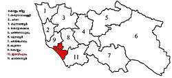
Eravipuram constituency in Kollam district | |
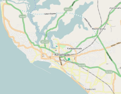 Eravipuram  Eravipuram Location in Kollam, India | |
| Coordinates: 8°52′0″N 76°37′0″E / 8.86667°N 76.61667°ECoordinates: 8°52′0″N 76°37′0″E / 8.86667°N 76.61667°E | |
| Country |
|
| State | Kerala |
| District | Kollam |
| Languages | |
| • Official | Malayalam, English |
| Time zone | IST (UTC+5:30) |
| Nearest city | Kollam City (8 km) |
Eravipuram is a Neighbourhood of the city of Kollam in Kerala, India. It is one among the 6 zones of the Kollam City Corporation. Other zones of the city of Kollam are Central Zone-I, Central Zone-II, Sakthikulangara, Kilikollur and Vadakkevila.[1]
Location
Eravipuram town is only 8 km away from Kollam city. Other nearby towns are Kottiyam, Mayyanad, Paravur etc. Paravur is 19 km away from Eravipuram. Eravipuram railway station is the nearest railway station, which is one among the 3 railway stations serving the city of Kollam.
Geography
This place has a long coastal line with Arabian Sea.
State government offices
- Eravipuram, Sub Registrar Office
- Assistant Director of Agriculture,Eravipuram, Valathungal P.O
- Eravipuram, Krishi bhavan, Valathungal P.O
- Eravipuram Village office, Valathungal P.O
Education
- Schools in Eravipuram
- Bishop Jerome English Medium Public School
- St John's High School, Eravipuram
- Govt.HSS,Valathungal
- Govt.VHSS,Valathungal
- Govt.Primary School,Valathungal
- Believer's Church Mahathma Central School
- CVMLPS school, Thanni
- Mannam Memmorial School,Pinaykkal
- Govt:Higher Secondary School,Eravipuram,Thattamala
- Eravipuram Railway Station, Kavalpura.
- Nirmala Hospital,Kavalpura, Eravipuram.
- Aalummoodu Siva Kshethram.
- St. John's Baptist Church,Eravipuram
- Lord Krishna Temple
- Sree Saravana Temple(Vanchiyil Kovil)
- Kalarivathukkal Mahadevar Temple
- Valathungal Kavu
- Kolloorvila Juma Masjid
- ECHS Polyclinic
- Chthettinada Sree Durga/Bhadra Devi Kshethram.
- Chettinada Ambalakkulam, Eravipuram Jn, Eravipuram.
- Puthennada Sree Durga Devi Kshethram.
- Puthennada Varuvil Kavu Kshethram.
- Snehatheeram Tsunami Residence Association, Vadakkumbhagam
- Civil supply.,Thirumukku
See also
External links
| Wikimedia Commons has media related to Eravipuram. |
References
- ↑ "Building Permit Management System -Kollam Corporation". Retrieved 16 December 2014.
| City Corporations |  | ||||||||||||||||||||||
|---|---|---|---|---|---|---|---|---|---|---|---|---|---|---|---|---|---|---|---|---|---|---|---|
| Municipalities | |||||||||||||||||||||||
| Talukas and villages |
| ||||||||||||||||||||||
This article is issued from Wikipedia - version of the 10/5/2016. The text is available under the Creative Commons Attribution/Share Alike but additional terms may apply for the media files.