Kollam Bypass
| Kollam Bypass | |
|---|---|
| കൊല്ലം ബൈപ്പാസ് | |
 | |
 | |
| Route information | |
| Maintained by National Highways Authority of India | |
| Length: | 8.16543884 mi (13.14100000 km) |
| Status: | Under Construction |
| History: | Planned in 1972 |
| Major junctions | |
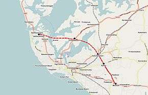
| South end: | Mevaram in South Kollam |
|
Ayathil Kallumthazham Kadavur Aravila | |
| North end: | Kavanad in North Kollam |
| Highway system | |
Kollam Bypass (Malayalam: കൊല്ലം ബൈപ്പാസ്) is a bypass road under construction in the NH 66 that bypasses CBD of the historic Kollam City in Kerala, India. The 13.141 km long bypass starts at Kavanad in the north to Mevaram in the south, via Aravila, Kadavur, Kallumthazham and Ayathil.[1]
Government of Kerala has proposed Kollam bypass project in 1972. The then Public Works Department minister Mr. T. K. Divakaran was the man behind Kollam bypass project. A stretch of 3 km from Mevaram to Ayathil has been completed in 1993 and 1.5 km Ayathil-Kallumthazham stretch has been completed in 1999. Kallumthazham-Kavanad stretch is still remaining.[2] This stretch includes three bridges, five culverts, one vehicle underpass, and five major intersections and needs to pass over the Ashtamudi Lake. The section will includes a seven- metre two-lane carriageway, paved shoulders and earthen shoulders.[3][4] The importance of the Kollam bypass is, it will touch 3 major National Highways(NH 66(Formerly known as NH 47), NH 183 (Formerly known as NH 220), NH 744 (Formerly known as NH 208)) passing through the state of Kerala.
Junctions
- Kavanad (Towards Mumbai through NH 66)
- Aravila
- Kadavur (Towards Theni through NH 183 )
- Kallumthazham (Towards Tirumangalam through NH 744)
- Ayathil (Towards Kulathupuzha through State Highway)
- Mevaram (Towards Thiruvananthapuram through NH 66)
Latest developments on bypass project
- 18 bidders have qualified for the bypass tender process - April 2014[5]
- Government of India and Government of Kerala have decided to share the cost of Kollam bypass project equally - May 2014[6]
- National Highway Authority of India is planning to re-tender the work with a change in estimate cost.[7][8]
- Government of India has granted approval for Kollam bypass, a joint venture of the State and the Central governments in January 2015.[9][10]
- Chief Minister of Kerala Oommen Chandy signed an agreement with a private company on 11 February 2015 to complete the works within 30 months. The total cost for works would be Rs.352 crore. The Government of Kerala has added the Kollam bypass project to its list of mega projects.[11]
- Preliminary works for Kollam bypass has been commenced again on 4 March 2015 after a long gap. Currently, clearing of the way for bypass is going on here. Re-aligning of telephone cables, water pipelines and KSEB feeder lines will commence soon as part of this work.[12]
- Mr. Nitin Gadkari, Union Minister for Road Transport and Highways and Kerala Chief Minister Mr. Oommen Chandy have jointly inaugurated the third phase construction work of Kollam bypass on 10 April 2015.[13][14]
- 26 November 2017 is the final deadline for the completion of Kollam Bypass. If the construction company fails to meet the deadline, a fine will be imposed on the company based on the delayed days. Ram Dayal Sharma-Cheriyan Varkey Construction companies are jointly working on this project[15]
Gallery
 Construction of Kollam Bypass near Thrikkadavoor
 100m long Kadavoor bridge under construction
 Bypass construction towards Kallumthazham
 900m long Kandachira bridge under construction
See also
References
| Wikimedia Commons has media related to Kollam Bypass. |
- ↑ Kollam bypass: Central team conducts alignment study
- ↑ Talks held on NH bypass completion
- ↑ Bypasses to take 3 years for completion
- ↑ Fears over construction of Kollam, Alappuzha NH bypasses
- ↑ Kollam, Alappuzha bypass work to be re-tendered
- ↑ Centre and Kerala Govt to share Kollam, Alappuzha bypass project equally
- ↑ Decks cleared for bypass work at Alappuzha, Kollam
- ↑ Nod to Kollam, Alappuzha bypass road in Kerala
- ↑ "National highway works to resume immediately in Kerala: Gadkari - Business Standards". Business Standards. Retrieved 14 January 2014.
- ↑ "100 Bridges to be Opened in 400 Days, Says Minister - The New Indian Express". The New Indian Express. Retrieved 14 January 2014.
- ↑ "Bypass works to be over in 30 months - The Hindu". The Hindu. Retrieved 12 February 2015.
- ↑ "Preliminary work on Kollam bypass begins - The Hindu". The Hindu. Retrieved 9 March 2015.
- ↑ "Phase II work of Kollam bypass from April 10 - The Hindu". The Hindu. Retrieved 24 March 2015.
- ↑ "Work on Kollam-Alappuzha bypass inaugurated". Manorama. Retrieved 14 April 2015.
- ↑ "MP inspects bypass work". The Hindu. Retrieved 29 February 2016.