Kottarakkara
| Kottarakkara കൊട്ടാരക്കര | |
|---|---|
| Municipality | |
|
| |
 Kottarakkara  Kottarakkara Location in Kerala, India | |
| Coordinates: 08°59′00″N 76°46′00″E / 8.98333°N 76.76667°ECoordinates: 08°59′00″N 76°46′00″E / 8.98333°N 76.76667°E | |
| Country |
|
| State | Kerala |
| District | Kollam |
| Government | |
| • Body | Kottarakkara Municipality |
| Languages | |
| • Official | Malayalam |
| Time zone | IST (UTC+5:30) |
| PINCODE | 691506 |
| Vehicle registration | KL-24-x-xxxx |
| Nearest city | Kollam (27 km), Punalur (17 km), Karunagapally(32 Km) |
| Lok Sabha constituency | Mavelikara |
| Civic Agency | Kottarakara Municipality |
.jpg)


Kottarakkara (IAST: Koṭṭārakkara), also transliterated as Kottarakara, is a town and municipality in Kollam (formerly known as Quilon) District, in Kerala state, India. The town is close to Kollam Port, which has a rich history linked to the early medieval period as well as a reputation as an important commercial, industrial and trading center. Kottarakkara lies 27 kilometres (17 mi) to the east of Kollam city center and 18 kilometres (11 mi) to the west of Punalur city on National Highway 208/220. It lies 35 kilometres (22 mi) north-east of Paravur.[1][2]
History
Kottarakkara, also known in the ancient days of the kings as the Elayadathu Swarupam, was a principality ruled by a branch of the Travancore Royal Family. It is the home of Kathakali, a well known dance drama which originated initially as Ramanattam created in the 17th century by Prince Kottarakkara Thampuran and later patronized by the Raja of Kottarakkara in the early 19th century absorbing other dance forms of Krishnattam with further innovations. Other historical places of interest include the Ganapathi Temple, Edakkidom Thettikkunil Maha Devi Temple and the more-than-700-year-old Mar Thomas Church.
Etymology
Kottarakkara, a compound word made up of the words Kottaram, meaning "palace", and kara meaning "land", literally means "land of palaces". The area which had several palaces was thus named "Kottarakkara."[3]
Geography
Kottarakkara is a small principality close to Kollam. It is now a modern taluk town with all essential facilities. As a taluk headquarters, it has six panchayats. It is surrounded by several other towns namely, the Chengamanadu (ചെങ്ങമനാട്)- (5 km from Kottarakara town), Vettikkavala 7 km ,Aipalloor (3 km from Kottarakara), Kizhaketheruvu (2.5 km from Kottarakara), Karickom, Thrikkannamangal, Nellikunnam, Kottathala, Moozhikkodu, Vendar, Mylom, Kalayapuram, Puthur, Poovattoor, Valakom, Neduvathoor, Neeleswaram, Pinattinmudu, Ambalathumkala, Ambalapuram, Annoor, Kareepra, Edakkidom, Kulakada, Nedumonkavu and many others.
NH 208 (Kollam to Thirumangalam) meets the MC road (Thiruvananthapuram to Angamaly) at Kottarakkara. Kottarakkara is linked with Kollam (the district headquarters), both by road and rail, at a distance of 27 km. It is 72 km to the north of Thiruvananthapuram (the capital of Kerala) and 80 km to the south of Kottayam.[1][3][4][5]
Politics
Kottarakara Assembly Constituency is part of the Mavelikkara (Lok Sabha constituency).[6]
Aisha Potty -MLA of Kottarakara constituency has been representing Kottarakara in Kerala Legislative Assembly as CPI(M) Member for two consecutive terms.The constituency has returned the following candidates after the formation of Kerala State in 1956. 1957: E Chandrasekaran Nair (CPI) 1960: D.Damodaran Potti (PSP) 1965: R.Balakrishna Pillai (Kerala Congress) 1967: E.Chandrasekaran Nair (CPI) 1969 (Bye election):C.Achutha Menon (CPI), Chief Minister 1970: Kottara Gopalakrishnan (INC) 1977, 1980, 1982, 1987, 19991, 1996, 2001: R.Balakrishna Pillai (Kerala Congress - B)
Landmarks
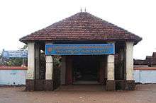
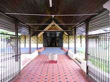
The town contains many notable places of worship, including Sree Maha Ganapthy Temple (in the suburb of Kizhakkekara), dated to the 10th-11th century, shrine of Ganapathy, Mahadeva Temple (in the western suburb of Padinjattinkara), Kottarakkara Goshala and Kulasekharanellor Sree BhadraKali Temple, amongst many other temples.
- Kottarakkara Sree Manikanteswara Mahadeva
Kottarakkara Sree Manikanteswara Mahadeva Temple is located near the "Althara", on the northern side. Shiva in the form of a fierce hunter is deified here. Another shrine next to it is a Durga temple, where the deity installed is known as Pazenadu Bhagavathy. Devi[7] The idol of was carved out from the root of the jack tree by Perumthachan.[8]
Edakkidom (ഇടയ്ക്കിടം) Thettikkunil Sree mahadevi temple near kottarakkara[4]
Ambalapuram Shri Gauri Shankara Temple, Ambalapuram
Transportation
Road
Transportation is mainly dependent on private buses as well as the state run KSRTC buses. It is well connected to the capital city of Kerala, Thiruvananthapuram by KSRTC Fast Passenger, super fast, deluxe, a/c buses. Buses are also ply to the district headquarters of Kollam and Pathanamthitta and to towns in Tamil Nadu like Coimbatore, Tenkasi and Sengottai and Daily trips to Mookambika, Munnar, Bangalore, Kumali, Ooty,kanyakumari,nagercoil, thirunelveli,palani
Rail
Kottarakara railway station is located on the Kollam-Sengottai railway line. Kottarakara railway station, which currently connects to Kollam, Trivandrum, Ernakulam, Thrissur, Madurai, Nagercoil, Paravur, Tirunelveli, Guruvayur, Varkala and Punalur through the direct passenger and fast passenger services. There are six pairs of services right now and heard that many more services would be inducted in this route since the Punalur-Schengotta ghat section has been closed for Broad Gauge conversion. Once the conversion is over, this will serve as the shortest route from Kollam to Chennai and from Kollam Port & Cochin Port to Tuticorin Port. Further, a new line from Chengannur to Thiruvananthapuram via Kottarakkara is awaiting survey. Kottarakkara will become a junction once the new line materializes.
Air
The nearest airport is Trivandrum International Airport in Thiruvananthapuram. A new green field airport has been proposed at Aranmula, 45 kilometres (28 mi) from Kottarakkara.
Notable individuals
- Malayalam novelists Lalithambika Antharjanam and Kakkanadan
- Kottarakara Sreedharan Nair (1922–1986), actor
- Murali (actor) (1954–2009)
- Veliyam Bhargavan, Sahavu, Former General Secretary, Communist Party of India
- R. Balakrishna Pillai, Former Minister, MLA, MP and Panchayat President, Chairman of the Kerala Congress (B).
- Bobby Kottarakkara, Malayalam actor
- K. B. Ganesh Kumar, actor and politician
- Saikumar, Malayalam actor
- Sgb Kottarakkara ,Novelists
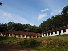
Schools & Colleges
- Mar Baselios English Medium School, Kottapuram,
- Sri Vidyadhiraja Memorial Model HSS, Vendar, Kottarakara.
- Govt. Boys' Higher Secondary School, Kottarakara,
- St. Gregorios High School, College Junction, Kottarakara,
- St. Gregorios Higher Secondary School, College Junction, Kottarakara
- Marthoma Girls' Higher Secondary School, Kottarakara
- St. Gregorios College
- University Institute of Technology (UIT)
- IHRD College of Engineering, Thrikkannamangal
- Mercy college of Nursing, Valakom
- Vijaya Nursing College
- Sree Sankara Sanskrit Vidhyapeedom, Edakkidam (ഇടയ്ക്കിടം)
References
- 1 2 "Kollam Town". Kollam District officialwebsite National Informatics Centre. Retrieved 22 February 2011.
- ↑ "Short History of Kollam". Kollam: National Informatics Centre. Retrieved 22 February 2011.
- 1 2 "History". kottarakkara.com. Retrieved 23 February 2011.
- 1 2 "Kottarakkara Taluk". Kollam; National Informatics centre. Retrieved 22 February 2011.
- ↑ "District Information". Kollam: National Informatics. Retrieved 22 February 2011.
- ↑ "Assembly Constituencies - Corresponding Districts and Parliamentary Constituencies" (PDF). Kerala. Election Commission of India. Archived from the original (PDF) on March 4, 2009. Retrieved 2008-10-20.
- ↑ K. Srikumaran (1 January 2005). Theerthayathra: a pilgrimage through various temples. Bharatiya Vidya Bhavan. p. 129. ISBN 978-81-7276-363-3. Retrieved 23 February 2011.
- ↑ "Kottarakkara". Kottarapuram Family Club. Retrieved 23 February 2011.
1.^ "Kollam Town". Kollam District official website National Informatics Centre. Retrieved 22 February 2011.
2.^ "Short History of Kollam". Kollam: National Informatics Centre. Retrieved 22 February 2011.
3.^ a b c d "History". kottarakkara.com. Retrieved 23 February 2011.
4.^ "Kottarakkara Taluk". Kollam; National Informatics centre. Retrieved 22 February 2011.
5.^ "District Information". Kollam: National Informatics. Retrieved 22 February 2011.
6.^ "Kottarakkara". Kottarapuram Family Club. Retrieved 23 February 2011.
7.^ C. Rajendran; University of Calicut. Dept. of Sanskrit (2002). Living traditions of Nāṭyaśāstra. New Bharatiya Book Corp. ISBN 978-81-87418-46-7. Retrieved 23 February 2011.
8.^ Parankamveettil; An ancient Hindu Pillai Converted Christian Family based from Aippalloor spreads areas at Kizhakketheruvu,Chengamanadu, Kottarakara,Elampal,Ayoor etc was Engaged in Agricultural Production,Tradings ,Religious,Social and Cultural activities. ISBN 978-81-87418-46-7. Retrieved 23 February 14.
9.^ K. Ayyappapanicker; Sahitya Akademi (1997). Medieval Indian literature: an anthology. Sahitya Akademi. pp. 317–. ISBN 978-81-260-0365-5. Retrieved 23 February 2011.
10.^ M. O. Koshy (1989). The Dutch power in Kerala, 1729-1758. Mittal Publications. pp. 64–. ISBN 978-81-7099-136-6. Retrieved 23 February 2011.
11.^ "New Kottarakkara portal". Xomba.com. Retrieved 23 February 2011.
12.^ "Assembly Constituencies - Corresponding Districts and Parliamentary Constituencies" (PDF). Kerala. Election Commission of India. Retrieved 2008-10-20.
13.^ K. Srikumaran (1 January 2005). Theerthayathra: a pilgrimage through various temples. Bharatiya Vidya Bhavan. p. 129. ISBN 978-81-7276-363-3. Retrieved 23 February 2011.
Climate
| Climate data for Kottarakkara, Kerala | |||||||||||||
|---|---|---|---|---|---|---|---|---|---|---|---|---|---|
| Month | Jan | Feb | Mar | Apr | May | Jun | Jul | Aug | Sep | Oct | Nov | Dec | Year |
| Average high °C (°F) | 30.4 (86.7) |
31.2 (88.2) |
32.3 (90.1) |
32.4 (90.3) |
32.0 (89.6) |
29.9 (85.8) |
29.3 (84.7) |
29.5 (85.1) |
29.9 (85.8) |
29.8 (85.6) |
29.5 (85.1) |
29.8 (85.6) |
30.5 (86.88) |
| Average low °C (°F) | 22.4 (72.3) |
23.1 (73.6) |
24.5 (76.1) |
25.3 (77.5) |
25.4 (77.7) |
24.1 (75.4) |
23.6 (74.5) |
23.6 (74.5) |
23.8 (74.8) |
23.8 (74.8) |
23.4 (74.1) |
22.6 (72.7) |
23.8 (74.83) |
| Average precipitation mm (inches) | 17 (0.67) |
34 (1.34) |
67 (2.64) |
166 (6.54) |
261 (10.28) |
477 (18.78) |
411 (16.18) |
277 (10.91) |
228 (8.98) |
311 (12.24) |
214 (8.43) |
54 (2.13) |
2,517 (99.12) |
| Source: Climate-Data.org[1] | |||||||||||||
External links
| Wikimedia Commons has media related to Kottarakkara. |
- Official Web Site Of Kottarakara Mahaganapthi
- More detailed information about Kottarakkara
- Kottarakkara - General information
| City Corporations |  | ||||||||||||||||||||||
|---|---|---|---|---|---|---|---|---|---|---|---|---|---|---|---|---|---|---|---|---|---|---|---|
| Municipalities | |||||||||||||||||||||||
| Talukas and villages |
| ||||||||||||||||||||||
- ↑ "CLIMATE: KOTTARAKARA", Climate-Data.org. Web: .