Kalluvathukkal
| Kalluvathukkal കല്ലുവാതുക്കൽ Raj | |
|---|---|
| City | |
| Nickname(s): Jha | |
| Coordinates: 8°49′57″N 76°44′43″E / 8.83250°N 76.74528°ECoordinates: 8°49′57″N 76°44′43″E / 8.83250°N 76.74528°E | |
| Country |
|
| State | Kerala |
| District | Kollam |
| Area | |
| • Total | 35.69 km2 (13.78 sq mi) |
| Population (2001) | |
| • Total | 42,238 |
| • Density | 1,200/km2 (3,100/sq mi) |
| Languages | |
| • Official | Malayalam, English |
| PIN | 691578 |
| Area code(s) | 0474-257**** |
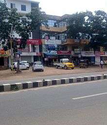
Kalluvathukkal is a village in the Kollam district of the Indian state of Kerala. NH 47 passes through the village.
Geography
Kalluvathukkal is located in the southern part of Kollam district, approximately 49 km north of the state capital, Thiruvananthapuram.
Demographics
According to the 2011 Census of India, Kalluvathukkal's population is 21,555 people, including 10,065 males and 11,490 females.
Transport
Paravur railway station is the nearest railway station, 13 km away. 10 pairs of express trains stop at Paravur. Kollam Railway Station is 22 kilometers from the village.
The nearest airport is Trivandrum International Airport, approximately 44 kilometers north on National Highway 47.
NH 47 passes through the center of the village.[1] Kalluvathukkal is well-connected to the main cities in the state and major towns in the district, including Trivandrum, Alappuzha, Kochi, Calicut, Kottarakara, Paravur, Kollam|Paravur, by National Highway 66 (India)|NH 66 and other state PWD roads.
Health care
- Vimala mission hospital, Kalluvathukkal, Kollam
- Sivapriya ayurvedic hospital, Karamkode, Kollam
- JSM Maternity hospital, Karamkode, Kollam
- Royal multi-specialty hospital, Chathannoor, Kollam
- ESIC Medical College, Parippally, Kollam
- Government Homeo Dispensary, Kalluvathukkal
Notables
- Elamkulam Kunjan Pillai
- Anwar Rasheed
- Nadakkal Sasi
| City Corporations |  | ||||||||||||||||||||||
|---|---|---|---|---|---|---|---|---|---|---|---|---|---|---|---|---|---|---|---|---|---|---|---|
| Municipalities | |||||||||||||||||||||||
| Talukas and villages |
| ||||||||||||||||||||||
References
| Wikimedia Commons has media related to Kalluvathukkal. |