Kollam Metropolitan Area
| Kollam Metropolitan Area കൊല്ലം നഗര സമൂഹം Kollam Urban Agglomeration | |
|---|---|
| Urban Agglomeration | |
|
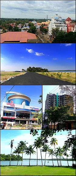
From top clockwise: Aerial view of Residency Road in Kollam city, Coastal Road in Paravur, A high-rise apartment building in Ramankulangara, Ashtamudi Lake view from Chavara, H&J Shopping Mall in Karunagappally | |
| Nickname(s): KMA | |
 Kollam Metropolitan Area Location in India | |
| Coordinates: 8°53′N 76°36′E / 8.88°N 76.60°ECoordinates: 8°53′N 76°36′E / 8.88°N 76.60°E | |
| Country |
|
| State | Kerala |
| District | Kollam |
| Government | |
| • Body | City Corporation of Kollam |
| Area | |
| • Total | 181 km2 (70 sq mi) |
| Population (2015)[1] | |
| • Total | 1,351,000 |
| • Density | 7,500/km2 (19,000/sq mi) |
| Languages | |
| • Official | Malayalam, English |
| Time zone | IST (UTC+5:30) |
| Vehicle registration |
KL-02(Kollam), KL-23(Karunagappalli), KL-24(Kottarakkara), KL-25(Punalur), KL-61(Kunnathur), KL 15(KSRTC) |
| Nearest city | Kollam |
| Sex ratio | 1095 ♂/♀ |
| Lok Sabha constituencies | Kollam, Mavelikkara(Part), Alappuzha(Part) |
| Planning agency | Kollam Development Authority (KDA) |
| Civic agency | City Corporation of Kollam |
Kollam Metropolitan Area or Kollam Urban Agglomeration is the 14th largest Urban Agglomeration in South India and 7th largest in Kerala.
The metropolitan area, constituted on the basis of 2011 census data, consists of Kollam Municipal Corporation (Quilon), 2 municipalities, 22 Panchayaths and parts of 2 Panchayaths. The two municipalities are Paravur and Karunagappalli. The 21 Panchayaths are Adichanalloor, Adinad, Ayanivelikulangara, Chavara, Elampalloor, Kallelibhagom, Kottamkara, Kulasekharapuram, Mayyanad, Meenad, Nedumpana, Oachira, Panayam, Panmana, Perinad, Poothakkulam, Thazhuthala, Thodiyoor, Thrikkaruva, Thrikkovilvattom, and Vadakkumthala. Outgrowth of Neendakara, Eravipuram and Thrikkadavoor panchayaths are also included in the Kollam Metropolitan Area.[2][3][4]
Constituents of the urban agglomeration
| No. | Location | Type |
|---|---|---|
| 1 | Kollam | City corporation |
| 2 | Neendakara | Outgrowth (Merged to city corporation) |
| 3 | Eravipuram | Outgrowth (Merged to city corporation) |
| 4 | Thrikkadavoor | Outgrowth (Merged to city corporation) |
| 5 | Paravur | Municipality |
| 6 | Karunagappalli | Municipality |
| 7 | Adichanalloor | Census Town |
| 8 | Adinad | Census Town |
| 9 | Ayanivelikulangara | Census Town |
| 10 | Chavara | Census Town |
| 11 | Elampalloor | Census Town |
| 12 | Kallelibhagom | Census Town |
| 13 | Kottamkara | Census Town |
| 14 | Kulasekharapuram | Census Town |
| 15 | Mayyanad | Census Town |
| 16 | Meenad | Census Town |
| 17 | Nedumpana | Census Town |
| 18 | Oachira | Census Town |
| 19 | Panayam | Census Town |
| 20 | Panmana | Census Town |
| 21 | Perinad | Census Town |
| 22 | Poothakkulam | Census Town |
| 23 | Thazhuthala | Census Town |
| 24 | Thodiyoor | Census Town |
| 25 | Thrikkaruva | Census Town |
| 26 | Thrikkovilvattom | Census Town |
| 27 | Vadakkumthala | Census Town |
See also
- List of million-plus urban agglomerations in India
- List of most populous urban agglomerations in Kerala
References
- ↑ "Demographia World Urban Areas" (PDF). Demographia. Retrieved 3 February 2016.
- ↑ "Thrikadavur becomes part of Kollam city". The Hindu. Retrieved 11 June 2015.
- ↑ "Kollam Urban Region". Census 2011. Retrieved September 21, 2014.
- ↑ "Kollam city population Census". census2011.co.in. Retrieved 16 December 2013.