Diamond Peak (Oregon)
| Diamond Peak | |
|---|---|
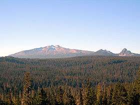 Diamond Peak volcano, with the smaller Mount Yoran to the right | |
| Highest point | |
| Elevation | 8,748 ft (2,666 m) NAVD 88[1] |
| Prominence | 3,104 ft (946 m) [2] |
| Coordinates | 43°31′15″N 122°08′58″W / 43.520696292°N 122.149582933°WCoordinates: 43°31′15″N 122°08′58″W / 43.520696292°N 122.149582933°W [1] |
| Geography | |
| Location | Klamath / Lane counties, Oregon, U.S. |
| Parent range | Cascades |
| Topo map | USGS Diamond Peak |
| Geology | |
| Age of rock | less than 100,000 years[3] |
| Mountain type | shield volcano |
| Volcanic arc | Cascade Volcanic Arc |
| Last eruption | more than ~11,000 years ago[4] |
| Climbing | |
| First ascent | 1852 John Diamond & William Macy[5] |
| Easiest route | hike[6] |
Diamond Peak is a shield volcano in southwest Oregon and is part of the Cascade Range. The mountain is located near Willamette Pass in the Diamond Peak Wilderness within the Willamette National Forest.
Composed of 15 cubic kilometres (3.6 cu mi)[4] of basaltic andesite, the volcano is older than the last ice age but probably younger than 100,000 years. It first began erupting from its northern summit and then from a new vent a little to the south, which is now the primary peak. The mountain has several cirques from glacial erosion. It lies directly on the Cascade Crest and therefore receives a heavy snow pack. Snow fields on the northern side may have been glaciers as recently as 100 years ago.[7]
History
William Macy and John Diamond climbed Diamond Peak in July 1852. These two men were part of a preliminary survey party known as the "Road Viewers." They climbed the peak in order to plan a road that later became known as the Free Emigrant Road. They named the peak for Diamond, who was a pioneer from Eugene. The road was completed in late September 1853, only days before some 1,027 people with 250 wagons arrived at the Deschutes River at what is now Bend. These emigrants, known as the "Lost Wagon Train of 1853," were following Elijah Elliott through the central Oregon high desert on what became known as the Elliott Cutoff. It took time to locate the road because it was 30 miles (48 km) upstream on the Deschutes. The road led them to Emigrant Pass by Summit Lake and then down the western side of the pass. In mid-October the emigrants were discovered on the Middle Fork Willamette River by the settlers of the upper Willamette Valley and a large rescue operation was launched to help the emigrants reach the settlements. This emigration doubled the population of Lane County.[8]
References
- 1 2 "Diamond". NGS data sheet. U.S. National Geodetic Survey. Retrieved 2008-04-01.
- ↑ "Diamond Peak, Oregon". Peakbagger.com. Retrieved 2008-04-01.
- ↑ "Diamond Peak Volcano". Deschutes & Ochoco National Forests. United States Forest Service. 2003-11-26. Archived from the original on 2011-05-12. Retrieved 2007-05-21.
- 1 2 Wood, Charles A.; Jürgen Kienle (1993). Volcanoes of North America. Cambridge University Press. p. 189. ISBN 0-521-43811-X.
- ↑ "Diamond Peak". Skiing the Cascade Volcanoes. Retrieved 2008-04-01.
- ↑ Wuerthner, George (February 2003). Oregon's Wilderness Areas: The Complete Guide. Westcliffe Publishers. pp. 96–97. ISBN 978-1-56579-434-4.
- ↑ "Cascades Volcano Observatory: Diamond Peak". U.S. Geological Survey. Archived from the original on 2013-10-02. Retrieved 2008-04-01.
- ↑ Sullivan, William L. (2002). Thurman, Paula, ed. Exploring Oregon's Wild Areas (Third ed.). The Mountaineers Books.
External links
| Wikimedia Commons has media related to Diamond Peak (Oregon). |
- "Diamond Peak". USGS topographic map. Internet Archives.
- "Diamond Peak Wilderness". GORP.
- "Diamond Peak". Geographic Names Information System. United States Geological Survey.
- "Diamond Peak". SummitPost.org.
| British Columbia |  | |
|---|---|---|
| Washington | ||
| Oregon | ||
| California | ||