Mount Garibaldi
| Mount Garibaldi | |
|---|---|
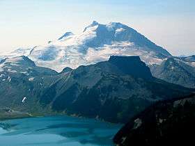
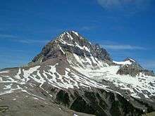
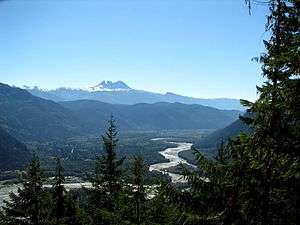
 Mount Garibaldi as seen from Squamish | |
| Highest point | |
| Elevation | 2,678 m (8,786 ft) [1] |
| Prominence | 855 m (2,805 ft) (estimated)[2] |
| Listing | |
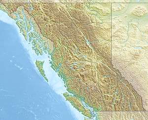
| Coordinates | 49°51′02″N 123°00′17″W / 49.85056°N 123.00472°WCoordinates: 49°51′02″N 123°00′17″W / 49.85056°N 123.00472°W [3] |
| Geography | |
 Mount Garibaldi | |
| Parent range | Garibaldi Ranges |
| Topo map | NTS 92G/14 |
| Geology | |
| Age of rock | Pleistocene |
| Mountain type | Stratovolcano |
| Volcanic arc/belt | |
| Last eruption | 8060 BCE ± 500 years[4] |
| Climbing | |
| First ascent | 1907 A. Dalton; W. Dalton; W. Dalton; A. King; T. Pattison; J.J. Trorey; G. Warren[2] |
| Easiest route | Glacier travel, snow climb |
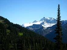
Mount Garibaldi is a potentially active[5] stratovolcano in the Sea to Sky Country of British Columbia, 80 km (50 mi) north of Vancouver, British Columbia, Canada. Located in the southernmost Coast Mountains, it is one of the most recognized peaks in the South Coast region, as well as British Columbia's best known volcano.[6][7] It lies within the Garibaldi Ranges of the Pacific Ranges.
This heavily eroded dome complex occupies the southwest corner of Garibaldi Provincial Park overlooking the town of Squamish.[8] It is the only major Pleistocene age volcano in North America known to have formed upon a glacier.[9] Although part of the Garibaldi Volcanic Belt within the Cascade Volcanic Arc, it is not considered part of the Cascade Range.[10]
Human history
Indigenous people
To Squamish people, the local indigenous people of this territory, the mountain is called Nch'kay. In their language it means "Dirty Place" or "Grimy One".[11] This name of the mountain refers to the muddy water in the Cheekye River.[3] This mountain, like others located in the area, is considered sacred for it plays an important part in their history. In their oral history, they passed down a story of the flood covering the land. During this time, only two mountains peaked over the water, and this mountain was one of them. It was here that the remaining survivors of the flood latched their canoes to the peak and waited for the waters to subside.[11] The mountain also serves as weather indicator to the people, as when clouds cover the face of the mountain, it signals the coming of rain or snow.[12] Cultural ceremonial use, hunting, trapping and plant gathering occur around the Mount Garibaldi area, but the most important resource was a lithic material called obsidian.[13] Obsidian is a black volcanic glass that was used to make knives, chisels, adzes, and other sharp tools in pre-contact times. This material appears in sites dated to 10,000 years ago up to protohistoric time periods. The source for this material is found in upper parts of the mountain area in higher elevations that surround the mountain range.[12]
Later history
British Explorer Captain George Vancouver reached Howe Sound in June 1792 and became the first European to see the mountain. During this time George Vancouver met and traded with the local natives in the area.[14]
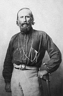
In 1860, while carrying out a survey of Howe Sound on board the Royal Navy survey ship HMS Plumper, Captain George Henry Richards was impressed by a gigantic mountain dominating the view to the northeast. Captain Richards, and his officers, renamed the mountain after the Italian military and political leader Giuseppe Garibaldi, who that year had succeeded in unifying Italy by patriating Sicily and Naples.[15] In August 1907, the Vancouver mountaineers A. Dalton, W. Dalton, A. King, T. Pattison, J.J. Trorey, and G. Warren reached the summit of Mount Garibaldi.[3] The views from the peak inspired the establishment of summer climbing camps at Garibaldi Lake.[15] This early interest led to the creation in 1920 of a park reserve.[15]
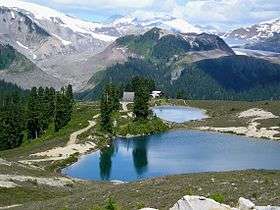
In 1927, Garibaldi was made into a large wilderness park called Garibaldi Provincial Park. Named after Mount Garibaldi, this 1,946.5 square kilometre park was established to protect the rich geological history, diverse vegetation, iridescent waters, abundant wildlife, and rugged mountains, many of which are capped by glaciers.[16]
When skiing caught on in the 1940s, Vancouver skiers began to search the glaciers and rugged mountains within the park. Early skiing was limited to the more easily reached area around Garibaldi Lake.[17] In the winter of 1944, a club group completed the first possible ski of Mount Garibaldi.[17] The famous mountaineers Don and Phyllis Munday completed lots of tracks additionally.[17] In the 1944-45 Canadian Alpine Journal, the Mundays reported a ski attempt on Mount Garibaldi with Phil Brook, who was a friend of the Mundays.[17] They skied on Sphinx Glacier and scrabbled Panorama Ridge just north of Garibaldi Lake during the same trip. Most importantly, during this period a road was built on Paul Ridge near the small community of Squamish at the north end of Howe Sound, thereby affording better vehicle approach to the highlands near Mount Garibaldi.[17] With easier access Vancouver skiers spent even more time on the glaciers of Mount Garibaldi. The result of this was the formation in the 1940s of the Garibaldi Névé Traverse, an overnight adventure that (weather permitting) can include a fine descent of Mount Garibaldi.[17]
Subsidiary peaks
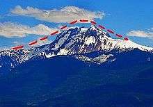
The broad top of Mount Garibaldi contains three named peaks. The highest peak is named as the mountain itself, reaching 2,678 m (8,786 ft) above sea level.[18] The second highest peak is the sharp pyramid of Atwell Peak at the southern edge of the summit plateau, which reaches a height of 2,655 m (8,711 ft) and lies on the southwest end of Garibaldi Provincial Park.[19] This peak is named after Atwell Duncan Francis Joseph King, leader of the first ascent of Mount Garibaldi in 1907.[19] The lowest of the three is the rounded Dalton Dome, 2,653 m (8,704 ft) high, west of the highest summit.[20] This peak is named after Arthur Tinniswood Dalton, one of the guides of the 1907 ascent.[20]
A feature on the north side of the mountain, known as The Tent, reaches 2,465 m (8,087 ft) and lies in Garibaldi Provincial Park.[21] Another minor summit on the south side of the mountain, 2,056 m (6,745 ft) high, is known as Diamond Head (sometimes Little Diamond Head) for its resemblance to Diamond Head in Hawaii.[22] Diamond Head was the site of a ski proposal and small lodge, now derelict. On the northwest side of Mount Garibaldi, Brohm Ridge lies outside the western boundary of Garibaldi Provincial Park.[23] The Sharkfin sticks up out of the Warren Glacier on the northeast side of the mountain with a height of 2,000 m (6,562 ft), just northeast of Squamish.[24] Columnar Peak rises on the south side of the mountain with a height of 1,826 m (5,991 ft), just southwest of Mamquam Lake at southwest end of Garibaldi Provincial Park.[25] Two pinnacles of volcanic rock 5 km (3 mi) south of Mount Garibaldi's summit, which attain heights of 1,816 m (5,958 ft) and 1,823 m (5,981 ft), have been known as The Gargoyles since 1978.[26]
Glaciers and icefields
Two pocket glaciers lie right below the east side of Atwell Peak, the Diamond Glacier to the southeast and the upper Bishop Glacier to the northeast. Straight north of Atwell toward Mount Garibaldi lies a small, high-elevation ice cap called the Cheekye Glacier, the name of which is associated with Cheekye River.[27]
A large icefield lies on the eastern and northern flanks of Mount Garibaldi called the Garibaldi Névé.[28] Its drainage is to the east into the Pitt River, to the southwest into Garibaldi Lake.[29] It has an area of 35 km2[29] and is an area of substantial snowfall with more than 5 m (16 ft) in many winters. The Garibaldi Névé is usually accessed from the south through the Bishop Glacier or from the north through the Sentinel Glacier.[29]
Climbing and recreation
Mountain climbing on Mount Garibaldi is fairly difficult; it is fairly steep-sided and involves climbing very loose rotten lava and volcanic ash. Fortunately, Mount Garibaldi has large areas of massive glaciation and extensive snowfields. The eastern and northern flanks of the mountain are smothered by the Garibaldi Névé where the finest climbing opportunities exist, making the easiest route a glacial travel or snow climb.[6] Routes keep mostly to the alpine glaciers and snow slopes, which are abundant in winter and spring, but eventually melt in late spring and commonly vanish after June or July of most years.[30] After the snow and ice melts, fissures and fractures can pose difficulty and danger, and avalanches from higher peaks of the mountain are a hazard.[30] For this reason, early season, cold-weather ascents are recommended for most routes up Garibaldi.
Hiking, photography, and camping are popular in the Garibaldi area. Several trailheads provide access to the backcountry.[31] In mid to late summer, visitors pass through meadows of wildflowers along alpine trails. Garibaldi Provincial Park is also popular for winter sports, including backcountry skiing and snowshoeing.
Geology
Mount Garibaldi lies within the Coast Plutonic Complex, which is the single largest contiguous granite outcropping in North America.[32] The intrusive and metamorphic rocks extend approximately 1,800 km (1,118 mi) along the coast of British Columbia, the Alaska Panhandle and southwestern Yukon. This is a remnant of a once vast volcanic arc called the Coast Range Arc that formed as a result of subduction of the Farallon and Kula Plates during the Jurassic-to-Eocene periods.[32] In contrast, Garibaldi, Meager, Cayley and Silverthrone areas are of recent volcanic origin.[10]
Mount Garibaldi is one of the few Cascade volcanoes that is made exclusively of dacite (Glacier Peak is the other).[8] The mountain has a unique asymmetrical shape because its main cone was constructed atop part of a large glacier system associated with the Cordilleran Ice Sheet that has since melted away.[8] Unlike many of the other Cascade volcanoes to the south, Garibaldi does not dominate the surrounding landscape, which consists of many high, rugged peaks. Many residents of Vancouver are therefore not aware that there is a volcano closer to the city than the more easily visible Mount Baker in Washington State.
Origins

Mount Garibaldi began erupting about 250,000 years ago and has grown steadily since then.[8] Like all of the Cascade volcanoes, Mount Garibaldi has its origins in the Cascadia subduction zone—a long convergent plate boundary that stretches from mid-Vancouver Island to Northern California.[33] The subduction zone separates the Juan de Fuca, Explorer, Gorda and North American Plates. Here, the oceanic crust of the Pacific Ocean sinks beneath North America at a rate of 40 millimetres (1.6 in) per year.[34] Hot magma upwelling above the descending oceanic plate creates volcanoes, and each individual volcano erupts for a few million years.
The subduction zone has existed for at least 37 million years, and has created a line of volcanoes called the Cascade Volcanic Arc which stretches over 1,000 km (621 mi) along the subduction zone.[6] Several volcanoes in the arc are potentially active.[35] Lassen Peak in California, which last erupted in 1917, is the southernmost historically active volcano in the arc, while Mount Meager, just north of Mount Garibaldi, which erupted about 2,350 years ago, is generally considered the northernmost.[36] A few isolated volcanic centres northwest of Mount Meager, such as the Silverthrone Caldera, which is a circular 20 km (12 mi) wide, deeply dissected caldera complex, are considered by some geologists to be the northernmost member of the arc.[37]
Structure

Mount Garibaldi is the largest volcano in southernmost British Columbia. Like other stratovolcanoes, it is composed of many layers of hardened lava, tephra, and volcanic ash. Eruptions are explosive in nature, and the most common form is the Peléan style, which involves viscous magma, glowing avalanches of hot volcanic ash and pyroclastic flows.[1][38] The source magma of this rock is classified as acidic, having high to intermediate levels of silica (as in rhyolite, dacite, or andesite).[39] The tephra deposits have lower volume and range than the corresponding Plinian and Vulcanian eruptions.[40]
Mount Garibaldi is known both for the very high quality exposures of its internal structure and for its conspicuous topographic anomalies, which can be attributed to the growth of the mountain onto a large glacier system and the subsequent collapse of the flanks of the volcano with the melting of the ice.[41] The western flanks of the mountain expose basement rocks, sheared and altered quartz diorite, carved by streams and glaciers into a rugged topography with relief up to 1,800 m (5,906 ft).[41] Valleys in this jagged surface have been filled with 0.52 to 0.22 million year old dacite and andesite flows, tuff breccias, and domes, precursors of the activity at Mount Garibaldi.[41] About 0.8 cubic miles (3.3 km3) of material remains in the volcano.[8] In modern times, the apron of material around the volcano's main vent extends at least 4.8 km (3 mi) from its source in places that were covered by ice. In other areas its extent is less and its slope is steeper.
Stratovolcanoes are a common feature of subduction zones.[42] The magma that forms them arises when water, which is trapped both in hydrated minerals and in the porous basalt rock of the upper oceanic crust, is released into mantle rock of the asthenosphere above the sinking oceanic slab. The release of water from hydrated minerals is termed "dewatering", and occurs at specific pressure/temperature conditions for specific minerals as the plate subducts to lower depths. The water freed from the subducting slab lowers the melting point of the overlying mantle rock, which then undergoes partial melting and rises due to its density relative to the surrounding mantle rock, and pools temporarily at the base of the lithosphere. The magma then rises through the crust, incorporating silica rich crustal rock, leading to a final intermediate composition. When the magma nears the surface it pools in a magma chamber under the volcano. The relatively low pressure of the magma allows water and other volatiles (CO2, S2−, Cl−) dissolved in the magma to begin to come out of solution, much like when a bottle of carbonated water is opened.[43] Once a critical volume of magma and gas accumulates, the obstacle provided by the volcanic cone is overcome, leading to a sudden explosive eruption.[43]
Ancestral stages of eruptive activity
The mountain grew in three phases. Garibaldi's first phase resulted in the creation of a broad composite cone made of dacite and breccia that has been potassium-argon dated to 250,000 years old.[8] Parts of this "proto-Garibaldi" or ancestral volcano are exposed on Garibaldi's lower northern and eastern flanks and on the upper 240 m (787 ft) of Brohm Ridge. Around where Columnar Peak and possibly Glacier Pikes are now located, a series of coalescing dacite lava domes were constructed. During the ensuing long period of dormancy, the Cheekye River cut a deep valley into the cone's western flank that was later filled with a glacier.[8]
After reaching its maximum extent the Cheekye Glacier along with part of the area's ice sheet were covered with volcanic ash and fragmented debris from Garibaldi. This period of growth began with the eruption of the Atwell Peak plug dome from a ridge surrounded by the several thousand foot ice sheet. As the plug dome rose, massive sheets of broken lava crumbled as talus down its sides. Numerous Peléan pyroclastic flows (consisting of a super-heated mix of gas, ash, and pumice) accompanied these cooler avalanches, forming a fragmental cone 6.3 cubic kilometres (1.5 cu mi) in volume and an overall slope of 12 to 15 degrees. (Erosion has since steepened this slope.)[8] Some of the glacial ice was melted by the eruptions, forming a small lake against Brohm Ridge's southern arm. The volcanic sandstones seen today atop Brohm Ridge were created by ash settling in this lake.[8]
Glacial overlap was most significant on the west and somewhat to the south.[8] Subsequent melting of the ice sheet and its component glaciers initiated a series of avalanches and mudflows on Garibaldi's western flank that moved nearly half of the original cone's volume into the Squamish Valley.[18] This series of debris flows carried 2.5 cubic kilometres (0.6 cu mi) of the mountain into the Squamish Valley where it covers 10 square miles (26 km2) to a thickness of about 300 feet (91 m).[8] Gaps left by melting ice caused minor to moderate cone distortion where the ice sheet was thin and major distortion where it was thick. The ice was thickest in and thus cone distortion was greatest over the buried Cheekye valley.
Soon before or after the buried ice had melted away, dacite lava quietly erupted from Opal Cone southeast of the Atwell Peak plug dome 10,700 to 9,300 years ago[1] and flowed 20 km (12 mi) down Ring Creek on Garibaldi's southern and southwestern flanks without encountering any residual glacial ice.[41] One of the lava flows traveled down a 30% to 35% grade over the landslide scar on the western flank.[8] About 0.15 cubic miles (0.63 km3) of dacite erupted in Garibaldi's third period of activity.[8] This lava forms a thin layer of solid rock on the southern and western sides of the volcano and contains well-defined lava flow margin levees.[1] The Ring Creek lava flow is very unusual because lengthy lava flows are usually attained by fluid basalt flows, except the Ring Creek flow is dacite.[38]
Current activity
Mount Garibaldi is one of the eleven Canadian volcanoes most strongly associated with recent seismic activity; the others are Castle Rock,[7] Mount Edziza,[7] Mount Cayley,[7] Hoodoo Mountain,[7] The Volcano,[7] Crow Lagoon,[7] Silverthrone Caldera,[7] Mount Meager,[7] Wells Gray-Clearwater Volcanic Field[7] and Nazko Cone.[44] The mountain is informally described as "dormant" ("asleep") because the mountain has not erupted in historic times, nor does it display fumarolic activity like nearby Mount Baker.[45] However, seismic data suggests that these volcanoes still contain living magma plumbing systems, indicating possible future eruptive activity.[46] Although the available data does not allow a clear conclusion, these observations are further indications that some of Canada's volcanoes are potentially active, and that their associated hazards may be significant.[5] The seismic activity correlates both with some of Canada's most youthful volcanoes, and with long-lived volcanic centres with a history of significant explosive behavior, such as Mount Garibaldi.[5] No hot springs are known in the Garibaldi area like those found at Mount Meager and Mount Cayley, the other major volcanic complexes in the Garibaldi belt, although there are hints of anomalously high local heat flow in Table Meadows and elsewhere.[47]
Volcanic hazards
Volcanic eruptions in Canada rarely cause fatalities because of their remoteness and low level of activity. The only known fatality due to volcanic activity in Canada occurred at the Tseax Cone in 1775, when a 22.5 km (14 mi) long basaltic lava flow travelled down the Tseax and Nass Rivers, destroying a Nisga'a village and killing approximately 2,000 people by volcanic gases.[48] Many towns and cities near Mount Garibaldi are home to over half of British Columbia's human population, and there is a likelihood that future eruptions will cause damage to populated areas, making Mount Garibaldi and other Garibaldi belt volcanoes a major hazard.[49] There are significant hazards from almost all Canadian volcanoes that require hazard maps and emergency plans.[50] Volcanoes which exhibit significant seismic activity, such as Mount Garibaldi, appear to be most likely to erupt.[50] A significant eruption of any of the Garibaldi belt volcanoes would significantly impact Highway 99 and communities like Pemberton, Whistler and Squamish, and possibly Vancouver.[50]
Explosive eruptions

Explosive eruptions from Mount Garibaldi would pose a severe threat to the nearby communities of Whistler and Squamish. Although no Plinian eruptions have been identified in Garibaldi's eruptive history, even Peléan eruptions could create large amounts of ash that could significantly affect these local communities.[38] Ash columns may rise to several hundred meters above the volcano, and due to its close proximity to Vancouver this could pose a threat for air traffic.[38] Melting of leftover glacial ice covering the Mount Garibaldi area may cause floods, lahars, or debris flows that could possibly threaten small communities such as Brackendale.[38] Highway 99 is already plagued by landslides and debris flows from the steep rugged Coast Mountains.[38] An eruption creating floods could demolish sections of the highway. Flooding and debris flows could also have severe issues for the salmon fishery on the Squamish, Cheakamus, and Mamquam rivers.[38] In addition, explosive eruptions and the associated ash column could cause short-and long-term water supply difficulties for Vancouver and most of the lower mainland.[38] The catchment area for the Greater Vancouver watershed is close to the Garibaldi area.[38] Pyroclastic fall could also have a deleterious effect on the ice fields to the east of Mount Garibaldi, causing more melting and spring flooding.[38] This in turn could endanger water supplies from Pitt Lake as well as fisheries on the Pitt River.[38]
Lava flows

The hazard from lava flows would be low to moderate because the nature of the lavas would prevent them from travelling far from their source, even though the Ring Creek lava flow ends only 6 km (4 mi) from Squamish.[38] Magma with high to intermediate levels of silica (as in andesite, dacite or rhyolite) commonly move slowly and typically cover small areas to form steep-sided mounds called lava domes.[51] Lava domes often grow by the extrusion of many individual flows less than 30 m (98 ft) thick over a period of several months or years.[51] Such flows will overlap one another and typically move less than a few meters per hour.[51] Lava flows with high to intermediate levels of silica rarely extend more than 8 km (5 mi) from their source; for example, Garibaldi's 20 km (12 mi) long Ring Creek dacite lava flow.
Landslides
In the past, Garibaldi has had large debris flows. A section of the mountain collapsed into the Cheakamus River valley when the glacier Garibaldi was built on melted, creating a jagged unstable slope at the head of the Cheekye River.[45] Repeated landslides from this steep cliff have created a huge debris fan at the mouth of the Cheekye River just north of Brackendale called the Cheekye Fan.[45] Danger from future collapses have limited the growth of Brackendale onto the fan.[45]
The steep northern edge of The Barrier in the Garibaldi area has partly collapsed several times, the most recent being in 1855-56.[38] This collapse created a large boulder field below it, which gave Rubble Creek its name.[38] Danger from future collapses prompted the provincial government to declare the area immediately below it unsafe for human habitation in 1981. This led to the evacuation of the small resort village of Garibaldi nearby, and the relocation of residents to new recreational subdivisions away from the hazard zone.[38] Although imminent danger is unlikely, special regulations exist to warn potential danger and to minimize the risk to life and property in the event of a landslide.[31]
Monitoring
Currently, Mount Garibaldi is not monitored closely enough by the Geological Survey of Canada to ascertain how active the volcano's magma system is.[52] The existing network of seismographs has been established to monitor tectonic earthquakes and is too far away to provide a good indication of what is happening beneath the mountain.[52] It may sense an increase in activity if the volcano becomes very restless, but this may only provide a warning for a large eruption.[52] It might detect activity only once the volcano has started erupting.[52]
A possible way to detect an eruption is studying Garibaldi's geological history since every volcano has its own pattern of behaviour, in terms of its eruption style, magnitude and frequency, so that its future eruption is expected to be similar to its previous eruptions.[52]
While there is a likelihood of Canada being critically effected by local or close by volcanic eruptions argues that some kind of improvement program is required.[5] Benefit-cost thoughts are critical to dealing with natural hazards.[5] However, a benefit-cost examination needs correct data about the hazard types, magnitudes and occurrences. These do not exist for volcanoes in British Columbia or elsewhere in Canada in the detail required.[5]
Other volcanic techniques, such as hazard mapping, displays a volcano's eruptive history in detail and speculates an understanding of the hazardous activity that could possibly be expected in the future.[5] At present no hazard maps have been created for Mount Garibaldi because the level of knowledge is insufficient due to its remoteness.[5] A large volcanic hazard program has never existed within the Geological Survey of Canada.[5] The majority of information has been collected in a lengthy, separate way from the support of several employees, such as volcanologists and other geologic scientists. Current knowledge is best established at Mount Meager north of Mount Garibaldi and is likely to rise considerably with a temporary mapping and monitoring project.[5] Knowledge at Mount Garibaldi and other volcanoes in the Garibaldi Volcanic Belt is not as established, but certain contributions are being done at least Mount Cayley.[5] An intensive program classifying infrastructural exposure near all young Canadian volcanoes and quick hazard assessments at each individual volcanic edifice associated with recent seismic activity would be in advance and would produce a quick and productive determination of priority areas for further efforts.[5]

The existing network of seismographs to monitor tectonic earthquakes has existed since 1975, although it remained small in population until 1985.[5] Apart from a few short-term seismic monitoring experiments by the Geological Survey of Canada, no volcano monitoring has been accomplished at Mount Garibaldi or at other volcanoes in Canada at a level approaching that in other established countries with historically active volcanoes.[5] Active or restless volcanoes are usually monitored using at least three seismographs all within approximately 15 km (9 mi), and frequently within 5 km (3 mi), for better sensitivity of detection and reduced location errors, particularly for earthquake depth.[5] Such monitoring detects the risk of an eruption, offering a forecasting capability which is important to mitigating volcanic risk.[5] Currently Mount Garibaldi does not have a seismograph closer than 25 km (16 mi).[5] With increasing distance and declining numbers of seismographs used to indicate seismic activity, the prediction capability is reduced because earthquake location accuracy and depth decreases, and the network becomes less accurate.[5] The inaccurate earthquake locations in the Garibaldi Volcanic Belt are a few kilometers, and in more isolated northern regions they are up to 10 km (6 mi).[5] The location magnitude level in the Garibaldi Volcanic Belt is about magnitude 1 to 1.5, and elsewhere it is magnitude 1.5 to 2.[5] At carefully monitored volcanoes both the located and noticed events are recorded and surveyed immediately to improve the understanding of a future eruption.[5] Undetected events are not recorded or surveyed in British Columbia immediately, nor in an easy-to-access process.[5]
In countries like Canada it is possible that small precursor earthquake swarms might go undetected, particularly if no events were observed; more significant events in larger swarms would be detected but only a minor subdivision of the swarm events would be complex to clarify them with confidence as volcanic in nature, or even associate them with an individual volcanic edifice.[5]
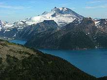
Garibaldi Lake volcanic field

Mount Garibaldi is associated with a group of small volcanoes that form the Garibaldi Lake volcanic field. An unusual volcanic structure called The Table is located between Garibaldi Lake and Mount Garibaldi.[53] This several-hundred-foot-high flat-topped volcano is made of layers of andesitic dacite that are arranged like a stack of more or less equal sized pancakes. The Table was formed in the early Holocene at a time when the Cordilleran ice sheet covered the region.[54] As the volcano's lava rose it melted the part of the ice sheet above The Table's vent, creating space for the lava to move into. Repeated eruptions constructed the steep-walled stack of lava seen today.
The Black Tusk is a large spire of extensively eroded dark volcanic rock that is shaped like a Walrus tusk. It is considered to be the remnant of an extinct andesitic stratovolcano which formed between about 1.3 and 1.1 million years ago.[54]
Mount Price, west of Garibaldi Lake, 5 km south of The Black Tusk, was formed in three stages of activity, dating back 1.1 million years, the latest of which produced two large lava flows from Clinker Peak during the early Holocene that ponded against the retreating continental ice sheet and formed The Barrier, containing Garibaldi Lake.[54]
Cinder Cone stands 150 m (492 ft) above a gap between two arms of Helmet Glacier on Garibaldi's flanks. During summer its crater is filled with a snow melt lake.
See also
- List of volcanoes in Canada
- Volcanism of Canada
- Volcanism of Western Canada
- Geology of the Pacific Northwest
Notes
- 1 2 3 4 Edwards, Ben (November 2000). "Mt. Garibaldi, SW British Columbia, Canada". VolcanoWorld. Retrieved 2008-05-10.
- 1 2 "Mount Garibaldi". Bivouac.com. Retrieved 2010-11-20.
- 1 2 3 "Mount Garibaldi". BC Geographical Names.
- ↑ Edwards, Ben (November 2000). "Mt. Garibaldi, SW British Columbia, Canada". VolcanoWorld. Retrieved 2008-05-10.
- 1 2 3 4 5 6 7 8 9 10 11 12 13 14 15 16 17 18 19 20 21 22 23 Etkin, David; Haque, C.E.; Brooks, Gregory R. (2003-04-30). An Assessment of Natural Hazards and Disasters in Canada. Springer. ISBN 978-1-4020-1179-5. OCLC 51667807.
- 1 2 3 The Cascade Episode Retrieved on 2008-05-11
- 1 2 3 4 5 6 7 8 9 10 Hickson, C.J.; Ulmi, M. (2006-01-03). "Volcanoes of Canada" (PDF). Natural Resources Canada. Retrieved 2007-01-10.
- 1 2 3 4 5 6 7 8 9 10 11 12 13 Harris, Stephen L. (1988). Fire Mountains of the West: The Cascade and Mono Lake Volcanoes. Mountain Press Publishing Company. pp. 283–288. ISBN 0-87842-220-X.
- ↑ Armitage, Doreen (2001). Around the Sound: A History of Howe Sound-Whistler. Harbour Publishing. ISBN 978-1-55017-235-5. OCLC 56329598.
- 1 2 "Garibaldi volcanic belt". Catalogue of Canadian volcanoes. Geological Survey of Canada. 2008-02-13. Retrieved 2008-05-10.
- 1 2 Yumks; Reimer, Rudy (April 2003). "Squamish Traditional Use Study: Squamish Traditional Use of Nch'kay Or the Mount Garibaldi and Brohm Ridge Area" (PDF). DRAFT. First Heritage Archaeological Consulting. Retrieved 2008-04-27.
- 1 2 Reimer, Rudy; Yumks (April 2003). "Squamish Nation Cognitive Landscapes" (PDF). 39th Annual Canadian Archaeological Conference. pp. 4–5. Archived from the original (PDF) on 2008-12-19. Retrieved 2008-05-19.
- ↑ Yumks; Reimer, Rudy (April 2003). "Squamish Traditional Use Study: Squamish Traditional Use of Nch'kay Or the Mount Garibaldi and Brohm Ridge Area" (PDF). DRAFT. First Heritage Archaeological Consulting: 8. Retrieved 2008-05-19.
- ↑ "Welcome To Squamish - British Columbia Canada". Squamish BC Canada. Retrieved 2008-04-26.
- 1 2 3 "Garibaldi Provincial Park". Government of British Columbia. Retrieved 2008-07-03.
- ↑ "BC Parks - Garibaldi Provincial Park, Sea to Sky Hwy, Whistler, British Columbia". Shangaan Webservices Inc. Retrieved 2008-04-27.
- 1 2 3 4 5 6 Dawson, Louis W. (1998-11-30). Wild Snow: A Historical Guide to North American Ski Mountaineering. Eric Blehm. ISBN 978-0-930410-81-0. Retrieved 2008-05-06.
- 1 2 "Garibaldi". Global Volcanism Program. Smithsonian Institution. Retrieved 2008-04-27.
- 1 2 "Atwell Peak". BC Geographical Names. Retrieved 2008-07-06.
- 1 2 "Dalton Dome". BC Geographical Names.
- ↑ "Tent, The (peak)". BC Geographical Names.
- ↑ "Diamond Head (mountain)". BC Geographical Names.
- ↑ "Brohm Ridge". BC Geographical Names.
- ↑ "Sharkfin, The (spur)". BC Geographical Names.
- ↑ "Columnar Peak". BC Geographical Names.
- ↑ "Gargoyles, The (peaks)". BC Geographical Names.
- ↑ "Cheekeye Glacier". BC Geographical Names.
- ↑ "Garibaldi Névé". BC Geographical Names.
- 1 2 3 "Garibaldi Neve". Bivouac.com - The Canadian Mountain Encyclopedia. Retrieved 2008-04-27.
- 1 2 "Garibaldi Provincial Park" (PDF). Government of British Columbia. Retrieved 2008-07-14.
- 1 2 "Garibaldi Provincial Park". Government of British Columbia. Retrieved 2013-03-26.
- 1 2 "The Coast Range Episode (115 to 57 million years ago)". Burke Museum of Natural History and Culture. Retrieved 2008-04-09.
- ↑ "The Cascadia Subduction Zone - What is it? How big are the quakes? How Often?". The Pacific Northwest Seismic Network. Archived from the original on 2008-05-09. Retrieved 2008-05-13.
- ↑ "1906 Earthquake A Reminder to Be Prepared". State of California: Department of Conservation. Retrieved 2008-05-11.
- ↑ "Living With Volcanic Risk in the Cascades". Dan Dzurisin, Peter H. Stauffer, James W. Hendley II. Retrieved 2008-04-27.
- ↑ "Meager". Global Volcanism Program. Smithsonian Institution. Retrieved 2008-05-11.
- ↑ "Preliminary petrography and chemistry of the Mount Cayley volcanic field, British Columbia" (PDF). Geological Survey of Canada. Retrieved 2008-05-11.
- 1 2 3 4 5 6 7 8 9 10 11 12 13 14 15 "Garibaldi volcanic belt: Garibaldi Lake volcanic field". Catalogue of Canadian volcanoes. Geological Survey of Canada. 2008-02-13. Retrieved 2008-04-29.
- ↑ "Activity Sheet 2: Eruption Primer" (PDF). Petty M. Donna. Retrieved 2008-07-05.
- ↑ "Kinds Of Volcanic Eruptions". VolcanoWorld. Archived from the original on May 15, 2008. Retrieved 2008-05-15.
- 1 2 3 4 Wood, Charles A.; Kienle, Jürgen (2001). Volcanoes of North America: United States and Canada. Cambridge, England: Cambridge University Press. ISBN 978-0-521-43811-7. OCLC 27910629.
- ↑ "Stratovolcanoes". University of Wisconsin-Eau Claire. Retrieved 2008-04-27.
- 1 2 "Composite Volcanoes and Stratovolcanoes, Subduction-Zone Volcanoes". USGS. Retrieved 2008-04-27.
- ↑ "Chronology of Events in 2007 at Nazko Cone". Natural Resources Canada. Retrieved 2008-04-27.
- 1 2 3 4 "Living in the shadow of volcanoes". Geoscape Vancouver. Natural Resources Canada. 2008-01-04. Retrieved 2008-07-05.
- ↑ "Volcanoes of Canada: Volcanology in the Geological Survey of Canada". Geological Survey of Canada. Retrieved 2008-05-09.
- ↑ "Geology and Geothermal Potential of the AWA Claim Group, Squamish, British Columbia" (PDF). Glenn J. Woodsworth, P. Geo. Retrieved 2008-04-27.
- ↑ "Tseax Cone". Catalogue of Canadian volcanoes. Geological Survey of Canada. 2005-08-19. Retrieved 2008-07-29.
- ↑ "Landslides and snow avalanches in Canada". Landslides. Geological Survey of Canada. 2007-02-05. Retrieved 2008-07-29.
- 1 2 3 "Volcanology in the Geological Survey of Canada". Volcanoes of Canada. Geological Survey of Canada. 2007-10-10. Retrieved 2008-07-29.
- 1 2 3 USGS. "Lava Flows and Their Effects". Retrieved 2007-07-29.
- 1 2 3 4 5 "Volcanoes of Canada: Monitoring volcanoes". Natural Resources Canada. Archived from the original on 2011-05-06. Retrieved 2008-05-19.
- ↑ "Table, The (mountain)". BC Geographical Names.
- 1 2 3 "Garibaldi Lake". Global Volcanism Program. Smithsonian Institution. Retrieved 2008-04-27.
References
- Mathews, Bill; Monger, Jim (2005). Roadside Geology of Southern British Columbia. Mountain Press Publishing Company. p. 404. ISBN 0-87842-503-9.
External links
| Wikimedia Commons has media related to Mount Garibaldi. |
- Garibaldi Provincial Park at BC Parks
| British Columbia |  | |
|---|---|---|
| Washington | ||
| Oregon | ||
| California | ||