Hayrick Butte
| Hayrick Butte | |
|---|---|
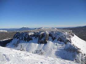 As seen from top of Hoodoo Ski Area | |
| Highest point | |
| Elevation | 5,523 ft (1,683 m) NAVD 88[1] |
| Prominence | 563 ft (172 m) [1] |
| Coordinates | 44°23′57″N 121°52′17″W / 44.3992857°N 121.8714477°WCoordinates: 44°23′57″N 121°52′17″W / 44.3992857°N 121.8714477°W [2] |
| Geography | |
 Hayrick Butte Location in Oregon | |
| Location | Linn County, Oregon, U.S. |
| Parent range | Cascades |
| Topo map | USGS Three Fingered Jack |
| Geology | |
| Age of rock | 80±20 thousand years[3] |
| Mountain type | Tuya |
Hayrick Butte is a tuya, a type of volcano, in the Cascade Range of northern Oregon, located in the Willamette National Forest near Santiam Pass and just west of the Cascade Crest. It is adjacent to the cinder cone, Hoodoo Butte, which overlaps its western edge.
A tuya is a type of subglacial volcano, formed when lava erupts underneath an overlying glacier or ice sheet and then melts through to the surface and pools, producing the flat plateau on top with near-vertical walls along the ice-contact margin as the lava cools and hardens. Hayrick Butte is one of the most perfectly formed examples of a tuya in the contiguous United States with a nearly flat triangular plateau about 0.5 miles (0.8 km) across and steep walls rising about 700 feet (210 m) above the plain below.
References
- 1 2 "Hayrick Butte". Peakbagger.com. Retrieved 2010-05-12.
- ↑ "Hayrick Butte". Geographic Names Information System. United States Geological Survey. Retrieved 2008-03-31.
- ↑ Sherrod, David R.; Edward M. Taylor (2004). "Geologic Map of the Bend 30- × 60-Minute Quadrangle, Central Oregon" (PDF). United States Geological Survey. p. 22. Retrieved 2016-04-29.
- Sources
- Harris, Stephen L. (2005). Fire Mountains of the West: The Cascade and Mono Lake Volcanoes (3rd ed.). Mountain Press Publishing Company. ISBN 0-87842-511-X.
- Wood, Charles A.; Kienle, Jürgen, eds. (1990). Volcanoes of North America. Cambridge University Press. ISBN 0-521-43811-X.
| Wikimedia Commons has media related to Hayrick Butte. |