Boring Lava Field
| Boring Lava Field | |
|---|---|
|
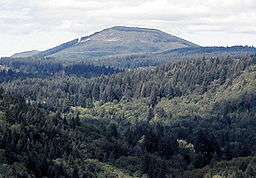
Bob's Mountain in Washington State | |
| Location | Oregon and Washington, U.S. |
| Coordinates | 45°18′N 122°30′W / 45.3°N 122.5°WCoordinates: 45°18′N 122°30′W / 45.3°N 122.5°W |
| Highest point – elevation – coordinates |
Larch Mountain[1] 4,061 feet (1,238 m) 45°18′N 122°30′W / 45.3°N 122.5°W |
| Geology | Volcanic field[2] |
| Age | Pleistocene[2] |
| Last eruption | > 300,000 years ago[2] |

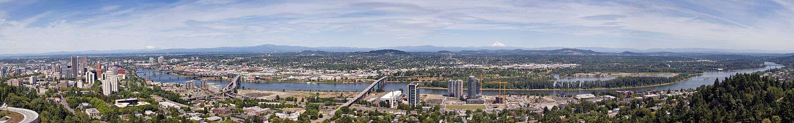
The Boring Lava Field is an extinct Plio-Pleistocene volcanic field zone with at least 32 cinder cones and small shield volcanoes lying within a radius of 13 miles (21 km) of Kelly Butte, which is approximately 4 miles (6 km) east of downtown Portland, Oregon, in the United States. The name is derived from the town of Boring, Oregon, which lies just to the southeast of the most dense cluster of lava vents. The zone became active at least 2.7 million years ago, and has been extinct for about 300,000 years.[2]
The Portland metropolitan area, including suburbs, is one of the few places in the continental United States to have extinct volcanoes within a city's limits; Bend, Oregon is another; for example Pilot Butte is a 500 foot high cinder cone located within the Bend city limits.
Oregon vents
The following vents are in Oregon:
- Chamberlain Hill - Elevation 890 feet (271 m)[3]
- Cook's Butte - Elevation 718 feet (219 m)[3]
- Highland Butte - Elevation 1,594 feet (486 m)[4] (near Beavercreek, Oregon)
- Kelly Butte - Elevation 400 feet (122 m)[3] (near the interchange of SE Powell Boulevard and I-205 in Portland)
- Larch Mountain - Elevation 4,061 feet (1,238 m)[1]
- Powell Butte - Elevation 614 feet (187 m)[5]
- Rocky Butte - Elevation 612 feet (187 m)[6] (stone tower with outstanding view of Portland)
- Ross Mountain - Elevation 1,380 feet (421 m)[3]
- Swede Hill - Elevation 995 feet (303 m)[3]
- Mount Scott - Elevation 1,093 feet (333 m)[4][7] (named for Harvey W. Scott)[8]
- Mount Sylvania - Elevation 978 feet (298 m)[9]
- Mount Tabor - Elevation 630 feet (192 m)[10] (center of a large multi-use Portland city park)
- Mount Talbert - Elevation 715 feet (218 m)[11]
- TV Hill - Elevation 1,275 feet (389 m)[3]
- Walker Peak - Elevation 2,450 feet (747 m)[4]
Washington vents
The following vents are in Washington:
- Battle Ground Lake - Elevation 509 feet (155 m)[12] (miniature crater lake)
- Bob's Mountain - Elevation 2,110 feet (643 m)[3] (contains intact summit crater)
- Bob's Mountain (N) - Elevation 1,775 feet (541 m)[3]
- Bob's Mountain (S) - Elevation 1,690 feet (515 m)[3]
- Brunner Hill - Elevation 680 feet (207 m)[3] (2 vents)
- Green Mountain - Elevation 804 feet (245 m)[3] (logged off during World War I)
- Mount Norway - Elevation 1,111 feet (339 m)[3]
- Mount Pleasant - Elevation 1,010 feet (308 m)[3]
- Mount Zion - Elevation 1,465 feet (447 m)[3]
- Nichol's Hill - Elevation 1,113 feet (339 m)[3]
- Pohl's Hill - Elevation 1,395 feet (425 m)[3]
- Prune Hill (W) - Elevation 555 feet (169 m)[3]
- Prune Hill (E) - Elevation 610 feet (186 m)[3] (overlooks Camas, Washington)
- Tum-Tum Mountain - Elevation 1,400 feet (427 m)[3] (located in Chelatchie, Washington)
References
- 1 2 "Larch Reset". NGS data sheet. U.S. National Geodetic Survey. Retrieved 2008-11-18.
- 1 2 3 4 Wood, Charles A.; Jűrgen Kienle (1990). Volcanoes of North America. Cambridge University Press. pp. 170–172.
- 1 2 3 4 5 6 7 8 9 10 11 12 13 14 15 16 17 18 19 Allen, John E. (September 1975). "Volcanoes of the Portland Area, Oregon" (PDF). The Ore Bin. Portland, Oregon: State of Oregon Department of Geology and Mineral Industries. 37 (9): 150. Retrieved 2009-06-16.
- 1 2 3 Allen, John E. (September 1975). "Volcanoes of the Portland Area, Oregon" (PDF). The Ore Bin. Portland, Oregon: State of Oregon Department of Geology and Mineral Industries. 37 (9): 151. Retrieved 2009-06-16.
- ↑ "Powell Butte". NGS data sheet. U.S. National Geodetic Survey. Retrieved 2008-04-02.
- ↑ "Rocky Butte Reset". NGS data sheet. U.S. National Geodetic Survey. Retrieved 2008-04-02.
- ↑ "Mount Scott". Geographic Names Information System. United States Geological Survey.
- ↑ "The Boring Lava Field: Portland, Oregon". United States Geological Survey. Retrieved May 21, 2010.
- ↑ "Sylvania Reset". NGS data sheet. U.S. National Geodetic Survey. Retrieved 2008-11-17.
- ↑ "Feature Detail Report ID 1136814: Mount Tabor Summit".
- ↑ "Mount Talbert". Geographic Names Information System. United States Geological Survey.
- ↑ "Battle Ground Lake". Geographic Names Information System. United States Geological Survey. Retrieved 2012-05-03.