Darwin, California
| Darwin | |
|---|---|
| census-designated place | |
|
Darwin, California | |
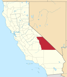
 Location in Inyo County and the state of California | |
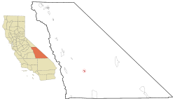
 Darwin Location in the United States | |
| Coordinates: 36°16′05″N 117°35′30″W / 36.26806°N 117.59167°WCoordinates: 36°16′05″N 117°35′30″W / 36.26806°N 117.59167°W | |
| Country |
|
| State |
|
| County | Inyo |
| Area[1] | |
| • Total | 1.345 sq mi (3.485 km2) |
| • Land | 1.345 sq mi (3.485 km2) |
| • Water | 0 sq mi (0 km2) 0% |
| Elevation[2] | 4,790 ft (1,460 m) |
| Population (2010) | |
| • Total | 36 |
| • Density | 27/sq mi (10/km2) |
| Time zone | Pacific (PST) (UTC-8) |
| • Summer (DST) | PDT (UTC-7) |
| ZIP code | 93522 |
| Area codes | 442/760 |
| FIPS code | 06-18030 |
| GNIS feature ID | 0241269 |
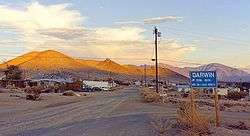
Darwin is a census-designated place (CDP) in Inyo County, California, United States. Darwin is located 22 miles (35 km) southeast of Keeler,[3] at an elevation of 4,790 ft (1,460 m).[2] The population was 43 at the 2010 census, down from 54 at the 2000 census. It is named after either Charles Darwin[4] or Dr. Darwin French.
Geography
According to the United States Census Bureau, the CDP has a total area of 1.3 square miles (3.4 km2), all of it land.
History
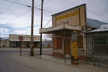
Silver and lead discovery at the place led to the founding of a settlement in 1874.[3][5] A post office opened in 1875, closed for a time in 1902, and remains open.[6] In 2011, the town was the subject of a documentary film, titled Darwin. In April 2012, BBC News featured a video of local residents describing their wishes to replace dial-up Internet access with broadband.[7]
Demographics
2010
The 2010 United States Census[8] reported that Darwin had a population of 43. The population density was 32.0 people per square mile (12.3/km²). The racial makeup of Darwin was 38 (88%) white, 0 (0%) black, 2 (5%) Native American, 1 (2%) Asian American, 1 (2%) Pacific Islander, 0 (0%) from other races, and 1 (2%) from two or more races. Hispanic or Latino of any race were 2 people (5%).
The Census reported that 43 people (100% of the population) lived in households; none lived in non-institutionalized group quarters or were institutionalized.
There were 28 households, out of which 0 (0%) had children under the age of 18 living in them, 11 (39%) were opposite-sex married couples living together, 0 (0%) had a female householder with no husband present, and 1 (4%) had a male householder with no wife present. There were 1 (4%) unmarried opposite-sex partnerships and 0 (0%) same-sex married couples or partnerships. 14 households (50%) were made up of individuals, and 9 (32%) had someone living alone who was 65 years of age or older. The average household size was 1.5. There were 12 families (43% of all households); the average family size was 2.1.
The population was spread out with 0 people (0%) under the age of 18, 0 people (0%) aged 18 to 24, 2 people (5%) aged 25 to 44, 20 people (47%) aged 45 to 64, and 21 people (49%) who were 65 years of age or older. The median age was 63.5 years. For every 100 females there were 168.8 males. For every 100 females age 18 and over, there were 168.8 males.
There were 46 housing units at an average density of 34.2 per square mile (13.2/km²), of which 24 (86%) were owner-occupied and 4 (14%) were occupied by renters. The homeowner vacancy rate was 4%; the rental vacancy rate was 0%. 37 people (86% of the population) lived in owner-occupied housing units, and 6 people (14%) lived in rental housing units.
2000
As of the census[9] of 2000, there were 54 people, 36 households, and 14 families residing in the CDP. The population density was 39.3 people per square mile (15.1/km²). There were 54 housing units at an average density of 39.3 per square mile (15.1/km²). The racial makeup of the CDP was 91% White, 2% Black or African American, 4% Native American, and 4% from two or more races. 6% of the population were Hispanic or Latino of any race.
There were 36 households out of which 8% had children under the age of 18 living with them, 22% were married couples living together, 14% had a female householder with no husband present, and 6% were non-families. 56% of all households were made up of individuals and 8% had someone living alone who was 65 years of age or older. The average household size was 1.5 and the average family size was 2.0.
In the CDP the population was spread out with 6% under the age of 18, 2% from 18 to 24, 17% from 25 to 44, 59% from 45 to 64, and 17% who were 65 years of age or older. The median age was 53 years. For every 100 females there were 145.5 males. For every 100 females age 18 and over, there were 142.9 males.
The median income for a household in the CDP was $13,333, and the median income for a family was $15,000. Males had a median income of under $2500 versus $36,250 for females. The per capita income for the CDP was $11,048. There were 33% of families and 38% of the population living below the poverty line, including 100% of under eighteens and none of those over 64.
Politics
In the state legislature, Darwin is in the 8th Senate District, represented by Republican Tom Berryhill,[10] and the 26th Assembly District, represented by Republican Devon Mathis.[11]
Federally, Darwin is in California's 8th congressional district, represented by Republican Paul Cook.[12]
See also
- Darwin Falls
- Darwin Falls Wilderness
- Darwin Hills
- Darwin, a 2011 documentary film about Darwin, CA
References
- ↑ "2010 Census U.S. Gazetteer Files – Places – California". United States Census Bureau.
- 1 2 U.S. Geological Survey Geographic Names Information System: Darwin, California
- 1 2 Durham, David L. (1998). California's Geographic Names: A Gazetteer of Historic and Modern Names of the State. Clovis, Calif.: Word Dancer Press. p. 1158. ISBN 1-884995-14-4.
- ↑ Gannett, Henry (1905). The Origin of Certain Place Names in the United States. Govt. Print. Off. p. 100.
- ↑ Robert P. Palazzo, Darwin, California, 1996.
- ↑ Robert P. Palazzo, Inyo County Post Offices and Postmasters 1866-1966, 2005.
- ↑ "Darwin, the town trapped by dial-up internet". BBC News. 2012-04-02. Retrieved 2012-04-03.
- ↑ "2010 Census Interactive Population Search: CA - Darwin CDP". U.S. Census Bureau. Retrieved July 12, 2014.
- ↑ "American FactFinder". United States Census Bureau. Retrieved 2008-01-31.
- ↑ "Senators". State of California. Retrieved April 11, 2013.
- ↑ "Members Assembly". State of California. Retrieved April 11, 2013.
- ↑ "California's 8th Congressional District - Representatives & District Map". Civic Impulse, LLC. Retrieved April 11, 2013.
Bibliography
- Palazzo, Robert P. Darwin, California, Lake Grove, OR: Western Places, 1996. The history of the boom and bust of this mining town from 1874-1878.
- Robert P. Palazzo. "Post Offices and Postmasters of Inyo County, California 1866-1966", Fernley, NV: MacDonald, 2005.