Cootes Store, Virginia
| Cootes Store | |
|---|---|
| Unincorporated community | |
|
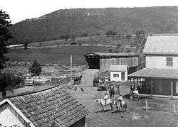
Cootes Store in 1895 | |
 Cootes Store  Cootes Store Location in Virginia | |
| Coordinates: 38°38′18″N 78°51′4″W / 38.63833°N 78.85111°WCoordinates: 38°38′18″N 78°51′4″W / 38.63833°N 78.85111°W | |
| Country |
|
| State | Virginia |
| County | Rockingham County |
| Elevation | 330 m (1,083 ft) |
Cootes Store is an unincorporated community in Rockingham County, Virginia, USA. Located in the Shenandoah Valley, it is situated north of Harrisonburg, south of Bergton, and west of Timberville. The border with West Virginia is nearby, as is the edge of George Washington National Forest.[1] Cootes Store is within a gorge where the North Fork Shenandoah River breaks, at the crossroads of Route 613 and Route 259.
Etymology
The name of the community is derived from that of Samuel Cootes,[2] owner of the eponymous store. He was a prominent local landholder and member of the community, who later served as a member of the Virginia House of Delegates.[2][3]
History
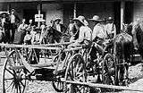
Isolated villages needed a general supply store, and Cootes supplied that need for two Virginia towns, Cootes Store and Dovesville (renamed Bergton).[4] Located a mile from Brocks Gap, Cootes Store was a rendezvous point for working men meeting on a Saturday afternoon, given its strategical location.[5] Historic photographs reveal that from earlier times it was always an agricultural community with cowboys. In 1870, merchants began using the Shenandoah River from Brock's Gap to Cootes Store for transporting people and goods.[6] By 1900, Cootes Store had a one-room public school.[7]
In 1936, Cootes Store and Bergton were affected by the Great Flood. At worst, the water was four feet deep and washed away many barns, cottages and other features in the area.[8]
Today, the community consists of many barns.
Transportation
Around 1880, a covered bridge was built over an older bridge at Cootes Store to cross the river's North Fork, placing the road at a higher level.[9] Like other towns along the Shenandoah River, Cootes Store also boasted a swinging bridge.[10]

Gallery


References
- ↑ Google Maps (Map). Google.
- 1 2 Hess, Nancy B. (1976). The Heartland, "Rockingham County". Christian Light Publications, Incorporated. ISBN 0-87813-225-2.
- ↑ Advertisement in the Rockingham Register, dated Saturday, January 23, 1836
- ↑ Suter, Scott Hamilton; Lyon, Cheryl (2004). Rockingham County. Arcadia Publishing. p. 98. ISBN 978-0-7385-1724-7.
- ↑ Wayland, John W. (2010). Virginia Valley records: genealogical and historical materials of Rockingham County, Virginia, and related regions. Genealogical Publishing Com. p. 236. ISBN 978-0-8063-0372-7.
- ↑ Sutcliffe, Andrea (2010). Touring the Shenandoah Valley Backroads (2 ed.). John F. Blair. p. 122. ISBN 0-89587-386-9.
- ↑ Couper, William (1952). History of the Shenandoah Valley, Volume 3. Lewis Historical Pub. Co.
- ↑ "flood at Bergton and Cootes Store highest recorded". Daily News Record. 1936. Retrieved December 15, 2010.
- ↑ Turner, Lena Albrite; Ritchie, Patricia Turner (2005). Brocks Gap. Arcadia Publishing. p. 14. ISBN 0-7385-4166-4.
- ↑ Turner & Ritchie, p. 42
External links
| Wikimedia Commons has media related to Cootes Store, Virginia. |
Municipalities and communities of Rockingham County, Virginia, United States | ||
|---|---|---|
| Towns | 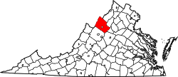 | |
| CDPs | ||
| Unincorporated communities |
| |
| Footnotes | ‡This populated place also has portions in an adjacent county or counties | |